
|
|
Route |
|---|---|
|
|
47.64678°N / 121.14482°W |
|
|
Hiking, Mountaineering |
|
|
Spring, Summer, Fall, Winter |
|
|
Half a day |
|
|
Moderate to Difficult |
|
|
Overview
Surprise Mountain, located in the Alpine Lakes Wilderness of Washington State, can be reached from multiple trails and directions. The route of least distance from a parking trailhead, however, is via Fisher Creek Trail #1059.1 off Forest Road 6830.
This route to the summit of Surprise Mountain is approximately 5.7 miles long, each direction. The route starts at an elevation of 3700', immediately drops to 3200' elevation, and then steadily climbs to the 6330' summit of Surprise Mountain from that point on. Fisher Creek Trail #1059.1, also known as the Deception Creek Cut-Off Trail, is a short trail that only serves as the beginning of this route. Several different trails comprise this route to Surprise Mountain.
Route Description
Hiking directions from the trailhead (3700' elevation) of Fisher Creek Trail #1059.1 (along Forest Road #6830) to the summit of Surprise Mountain: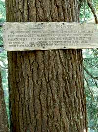
1) Hike east (downhill) along Fisher Creek Trail #1059.1 for 0.7 miles, ending at the junction (3200' elevation) with Deception Creek Trail #1059.
1a) One of the most notable things of this stretch of the route is a sign on a tree commemorating a long-time member of the Alpine Lakes Protection Society.
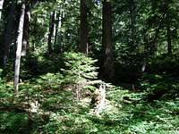
1b) Fisher Creek can be heard, but not seen, from this stretch of the route.
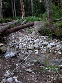 Fisher Creek
2) Hike south (right turn) along Deception Creek Trail #1059 for 2.5 miles, to the junction (4400' elevation) with Deception Lakes Trail #1059.2.
2a) Within 0.1 miles of this stretch of the route, the trail requires crossing over small Fisher Creek, near where the stream intersects Deception Creek.
2b) Within 0.2 miles of the Fisher Creek crossing, the trail splits. The trail to the left requires crossing through the river, the trail to the right leads to a footlog crossing over the river further upstream. Both ways are approximately equal distance to the route, overall.
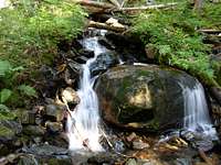
2c) After crossing Deception Creek, the trail (Deception Creek Trail #1059) winds south through an old-growth and second-growth forest. Several small stream crossings occur in various locations along this stretch of the route, with a split-stream crossing occurring approximately 0.2 miles from the next trail junction (Deception Lakes Trail #1059.2).
 Deception Lakes Trail #1059.2
3) Hike east (left turn) along Deception Lakes Trail #1059.2 for 0.8 miles, to the junction (5000' elevation) with Deception Lakes Trail #1059.A. This trail is actually a section of Pacific Crest Trail (PCT) #2000.
3a) This route switchbacks up a slope, heading east.
3b) The trail passes through a small boulder field approximately halfway along this stretch of the route.
 Large Boulder Field
4) Hike north (left turn) along Deception Lakes Trail #1059.A / PCT #2000 for 0.4 miles, to the junction (5100' elevation) with Surprise Mountain Trail #1063 at Deception Lakes. PCT #2000 turns right, while Surprise Mountain Trail #1063 continues straight.
4a) Within 0.1 miles along this stretch of the route, the trail passes through a large boulder field.
4b) Shortly after the large boulder field, the trail crosses a bridge over a stream originating from Deception Lakes.
4c) The southernmost of the Deception Lakes is passed shortly after the bridge crossing.
 "Horse Camp" Sign
5) Continue hiking north (straight). Soon after the PCT junction, the trail appears to split in multiple directions. There is a directional sign posted on a tree, pointing towards "Horse Camp", where the trails split.
5a) The trail to the right follows the lake and passes through a marsh leading to an open area which appears to be an illegal camping spot. From there, faint trails appear to lead around the lake and/or further into the wilderness.
5b) The tree with the "Horse Camp" sign has a sign below it which explains the delicate nature of the Deception Lakes area.
6) Follow the trail leading towards "Horse Camp". This is actually still Surprise Mountain Trail #1063. While traversing through forest, the trail appears to have several spurs leading from it. At these spur junctions, the main trail is always the one closest to Surprise Mountain (on the left side of the trail).
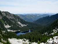 View From Surprise Gap
7) After approximately 0.7 miles from the "Horse Camp" sign, the trail reaches Surprise Gap (5700' elevation), a small saddle connecting Surprise Mountain (on the left/ west) to an unnamed peak (on the right/ east).
7a) At Surprise Gap, looking north, there are great views of Glacier Lake, Spark Plug Mountain, and far-away Glacier Peak.
7b) An old trail appears to head east up the unnamed peak.
7c) Another old trail appears to head down the north side of the saddle, towards Glacier Lake.
7d) The Surprise Mountain summit route is the trail steeply climbing the hillside to the west (left) of Surprise Gap.
 South Slope Summit Trail
8) Hike west (left) up the south slope of Surprise Mountain for approximately 0.6 miles, to the summit (6330' elevation).
8a) From Surprise Gap, the trail first steeply climbs an upper southeastern slope of Surprise Mountain.
8b) The trail then traverses, horizontally, across a sub-alpine meadow on the south side of the peak.
8c) The trail then climbs up north, through a meadow slope to the summit.
8d) In addition to views of many mountains and ridges, multiple alpine lakes can be seen from the summit of Surprise Mountain. These include Glacier Lake and Surprise Lake to the northeast, and Marmot Lake to the southwest.
Getting There
The total mileage from Skykomish, Washington, to the parking trailhead of Fisher Creek Trail #1059.1 is 23.0 miles. Here are the driving directions:1) Drive east along Highway 2 from Skykomish, Washington turnoff.
2) After 1.8 miles, take a right turn onto Foss River Road.
3) After 1.2 miles, Foss River Road becomes a gravel road, Forest Road 68.
4) After 2.3 miles further, veer left onto Forest Road #6830. This is a one-lane gravel road.
5) After 17.7 miles on Forest Road #6830, arrive at the trailhead for Fisher Creek Trail #1059.1, on the left (sloped) side of the road.
NOTE: Forest Road #6830 ends at a bridge washout approximately 0.2 miles further. The trailhead only has a very small area for parking, enough for one or two vehicles. Due to the very limited space for parking and turning a vehicle around, it is recommended to first drive to the end of Forest Road #6830, turn the vehicle around, and either park there or along the side of the road near the trailhead (if space allows).
Essential Gear
No essential gear is needed outside of "10 Essentials" and standard hiking gear/attire.Reference Green Trails Map #176 for route and topography information.
Red Tape
ALL visitors to the the Alpine Lakes Wilderness are required to have a Wilderness Permit from May 15 to October 31. Wilderness permits are free and can be obtained at parking trailheads and local ranger stations.*If parking a vehicle in the region, the trailheads within the Alpine Lakes Wilderness require a Northwest Forest Pass. A single-day Northwest Forest Pass costs $5, while an annual Northwest Forest Pass costs $30. Northwest Forest Passes can be purchased from ranger stations or REI stores (if not also other outdoor recreation stores) within Washington State.
Camping
Although several rugged campsites are found at various locations along this route, such as at Deception Creek and Deception Lakes, camping in these locations is NOT permitted.The closest permitted (designated) campsite near Surprise Mountain is located several miles north of the peak, near Surprise Lake.