Background
Mount Cleveland (10,466) is the highest mountain in Glacier National Park, Montana and it has several really great scrambling routes to the top. Each of these routes offers a very different experience, and they all culminate in a long, high, beautiful ridge walk to the summit. This mountain has a lot to offer for climbers of all levels and it is my favorite climb in the park.
In July 2005, my dad and I decided to try it by the west face route, described in the Edwards guide. We took the touristy boat from Waterton Lakes village to Goat Haunt and set up camp at Kootenai Lakes. That afternoon, we tried to find the mysterious elk trail that would shoot us into Cleveland’s west bowl, per the guide. However, after three hours of searching without finding, we decided that we’d have a better chance if we got up really early to do the Stoney Indian traverse from Kootenai Lakes.
This route starts by getting the climber above the trees on the Stoney Indian Lake trail. We got to the lake at around 5:30 am and it was incredible. The lake was as calm as glass and the back country campers hadn’t woken up yet. On one side of the lake, there’s a high vertical cliff dropping directly into the water. The trail curls around the lake and then walks directly beneath the cliff. On that passage, the trail is about 1 ½ feet wide: cliff on the left and lake on the right. The silence made me feel as if my footsteps were the only sound in the entire valley. This trail is one of the most beautiful I’ve ever been on—an incredible way to start a climb.
![Stoney Indian Peaks Traverse]()
From there, we scrambled up to Stoney Indian Pass and the side of Stoney Indian Peaks. On the shoulder of the peaks is a long goat trail that traverses all the way up to the south end of Cleveland. Our pace was really slow on this because we had never been on a goat trail and the exposure sketched us out a little. Well, by the time we reached the Cleveland-Stoney Indian pass, we had been out of water for a while and it was past turn-around time, so we ended the climb. We went back down to Kootenai Lakes camp via the valley beneath Cleveland’s west face. After thrashing through about a mile of alder branches as thick as my legs and 10 feet tall, we stumbled miraculously upon the fabled elk trail from the guide. After following it down for a couple of hours, we ended up right where we were looking for it the previous night.
Planning
![Routes up Mount Cleveland]() Blue = planned route. Yellow = actual route.
Blue = planned route. Yellow = actual route.Armed with the knowledge that an elk trail into the west bowl really exists, we decided to give it another go this year. We had worked out a route on Google Earth that looked really interesting and seemed to capture the spirit of John Edwards’ description. We went early in the season and snow levels were well above annual averages for that time of year. Before leaving Minnesota, I had been watching the Flattop Mountain SNOTEL readings from the National Weather Service website. This weather station is really helpful because it provides snow depths by the hour and it’s right in the middle of the park, at above 6000’ elevation. I find that weather data from surrounding communities just doesn’t do the trick—it could be balmy and dry in St. Mary, but Logan Pass could have 8 feet of snow. With the raw feeds from this instrument, I could watch how fast the snow was melting and get an idea of the avalanche danger before arriving in the park.
June 3: 105 inches. June 7: 89 inches. (“Great! The snow is melting quickly during the day. With any luck, all of that sun will help consolidate the snow nicely and we’ll have safe, easy walking.”) June 14: 115 inches. Big bummer. 2 feet of that snow fell in one night. Loose, wet, spring snow sitting on a hard old snow pack just gives me a warm fuzzy feeling inside. On top of that, the St. Mary web cam had looked dark and rainy for about a week straight before the trip. A lot of the time, I couldn’t even see St. Mary Lake when I went to sneak a peak from my office desk. We were looking forward to a hard trip.
The Approach
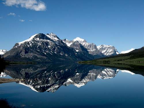
![Red Eagle Mountain]() Red Eagle Mountain, reflected in St. Mary Lake.
Red Eagle Mountain, reflected in St. Mary Lake.On June 15, we arrived in the park a little after supper time. The sky was perfectly clear and the temperature was in the 40s. We had pulled a nice little rabbit out of the hat on that deal. Since we were both too horny to look at a map, we made a very uninformed decision to scramble Red Eagle Mountain the next morning as our “warm up” day climb. The hike to the base of the scramble is 5 miles long and the elevation gain is about 4000 feet after that. While still walking back to the car after 10pm that night, I was thinking that maybe we hadn’t chosen a good scramble for a 9 am start on day one.
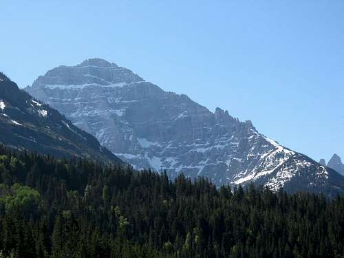
![Mount Cleveland North Face]() Mt. Cleveland from the tour boat.
Mt. Cleveland from the tour boat.Therefore, we delayed our start to Cleveland by one more day to rest and see Virginia Falls (which is always really cool in June). On June 17, we again hitched a ride on the touristy boat to Goat Haunt. The ticket lady looked at me like I was crazy when I told her our plans. I figured that this meant one of two things: either she was a very experienced climber who had done Cleveland a hundred times (in which case we were dead) or she didn’t climb at all and she would look at me the same way if it were August.
At Goat Haunt, the border officer was very nice to let us back into the US, considering that I look stoned and drunk on my passport picture, I incorrectly told him that I was born in Minnesota, and my dad quoted the wrong month for his birthday. Thanks guy.
He also gave me the “you’re crazy” look that I got from the gal at the ticket booth. “You know that it snowed all last week, right? All of that new snow on top of hard snow pack makes for perfect spring avalanche conditions.” Thanks for the reminder. (Note: I didn’t feel nervous because I thought that we were going to be “forced” to do something stupid and dangerous; I just didn’t want to get to the mountain and realize that we would have to call off the climb. We were there to wrap up unfinished business, after all.)
After setting up camp at Kootenai Lakes, we again went searching for the elk trail. This year, I brought a GPS, some trail marking tape, and a good memory. After less than an hour, we did find the trail we were looking for and we followed it up for a couple of hours, marking the turns along the way. We did this until the trail started breaking out of the trees and then headed back for supper. At camp, the lake was gorgeous and calm. We saw three moose, including a bull, playing in the water beneath the snow-covered mountains.
![Moose in Kootenai Lake]() Moose in Kootenai Lake
Moose in Kootenai LakeAfter having camped there for a total of four nights now, I’ve decided that it is simply one of the greatest campsites in the park. There is always a ton of wildlife, it’s much less busy than the rest of the park, the views are incredible, and it makes an excellent jump-off point for a number of great hikes and climbs. I highly recommend it to anyone.
Summit Day
The next morning, we got up at 4 am. I had argued for 3, but my dad convinced me that 4 was good enough, since the route is in the shadow of the morning sun. Following the elk trail was a cinch and it soon led to grassy shelves interspersed with short class 3 scrambling. The view back across the valley to Citadel Spires was bright with the early morning sun. At one point, I saw the tail end of a black bear running away from us as we crested a small rise onto a forested shoulder. I felt a little guilty for bothering it in its paradise and I thought that, if I were a bear, I would hope to have as nice of a home.
We had gained the first 2,000 feet and after about a half mile of traversing beneath the West face, the snow was prevalent, hard, and icy. We stopped to put on our crampons and surveyed the planned route. The couloir that cut into the west ridge looked very steep and choked with snow, but we thought that it might still go, so we planned to climb to the base of it to have a closer look. If it was too gnarly, we would traverse around the west ridge and try the face behind it.
![Mount Cleveland West Ridge]() Corniced west ridge, viewed from Kootenai Lake camp site.
Corniced west ridge, viewed from Kootenai Lake camp site.The part that concerned us was the 2,500 feet above the couloir. Our planned route was to traverse out onto the west face and climb straight up the snow to the summit ridge. However, the entire bowl was filled with recent avalanche activity in every gully (remember that 2 feet that fell in one night?). To make things worse, the north side of the west ridge is the leeward side, so it had a beautifully huge cornice hanging right over the route and the snow underneath it was a wind slab that looked like it had been growing for the whole winter—eagerly anticipating a couple of rubes like us to set it off. Nearby, we could clearly see the interface between the old snow and the new stuff that had fallen the prior week. We needed an alternate route, or we would turn back.
We decided that we’d still check out the steep couloir and then try to find a way to get on the other side of that cornice. The couloir turned out to be the technical crux of the climb and was really fun. The snow was hard and steep—from 45 to 75 degrees—and it was hemmed in on both sides by vertical rock. At times, when it was really narrow and steep, it helped to stem between the rock and the snow. It made me think that I’d really love mixed climbing. This went on for about 1,500 feet.
I had taped a helmet camera to my helmet so that I could film this section. When I got home, I watched an hour of blank snow, punctuated by an occasional ax being planted. I’m still bummed about that one. My advise is to get a big SD card for your camera and stop to take films of your partner. Hands-free filming doesn’t ever seem to work out.
Above the top of the couloir, there was a steep, narrow band of snow angling up to the top of the west ridge. We rested for 10 minutes and tried not to think too hard about the possibility of a false horizon. My dad led up to the top of it and I faintly heard happy yells coming from over the crest. As I came around the corner, I could see what appeared to be a continuous, snowy ridge that went all the way to the summit ridge. The wind was strong and it was reassuring to see tiny pockets of rock sticking out here and there—the snow here was well-packed and relatively safe from avalanche.
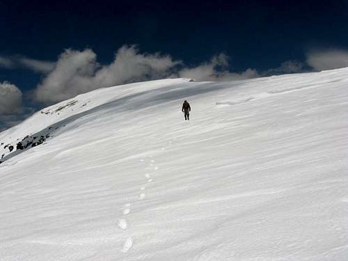
After having lunch, we slogged up another 2,200 feet on the snow, keeping a healthy distance away from the cornice. As we reached the summit ridge, we realized what flat-landers we really are as a cozy AMS headache set in for both of us. My dad felt fairly nauseous as well. Since we would only be bearing that for an hour or so, I decided that our risk was not enough to warrant turning back.
We slogged on for the final half mile or so, gaining the last 200 feet on the way. As gentle as this slope was, I would consider it a second crux for a few reasons. The wind was howling more loudly than it had at any other point on the climb—there were cornices on the east side sticking out a good 15 to 20 feet horizontally. Mixing that with our sickness, we ended up having to rest about every 30 or 40 steps. A half-hour later, we hugged on the summit and shot movies on my digital camera until the batteries didn’t work any more from the cold.
The view up there is really something. For a rush, I lied down and stuck my head out over the north face and looked down through 4,000 vertical feet of air. Wind blew chunks of snow into my face from the base of the mountain. We took turns walking to the top of the snow pile at the summit. My dad figures that the snow was about 10 feet high and he entertains that we therefore stood 10 feet higher than anyone has ever stood in Glacier National Park.
Epilogue
The ride down was not-surprisingly mushy. We hurried off of the snowy west ridge, which at that point looked ready to slide. By the time we had dropped beneath the snow onto the glacier-carved rock shelves below, we stopped next to a waterfall to make freeze-dried chicken a la king. After we sat down, I noticed a nearby cairn made from two stones standing up on end and I realized that I had made that cairn three years ago. We had joined up with the exact same descent route! Three grumpy hours of bushwhacking later and 16 hours after starting, we were lying down on the beach, looking back at the west bowl while the sun painted the snow orange and red. Thanks again, GNP!


Comments
Post a Comment