Friday, December 21, 2007 I took off work and did a local hike to prepare for the Christmas Holiday. The primary purpose of this hike was to find the actual highest point on Upper Table Rock. I had a topo map and GPS with me to help find the spot. The secondary purpose was to break in a new pair of boots. My old pair of Asolo Power Matic 200’s are falling apart after only 8 months and 500 miles of use. I want to try some Montrail Torre’s this time.
Upper Table Rock is a very popular trail with the locals and it is difficult to find solitude here even on a foggy day in the middle of winter. The trailhead is only about 10 miles from my house and since I’ve climbed both of the Table Rocks many times previously, I had no problem finding the parking lot. The parking lot at the trailhead is paved and even has a place for buses to park when school kids come here in the spring for a field hike.
I put on my boots and pack and headed up the trail. The trail is very nice and has been graded and graveled part way. The trail does deteriorate a little near the top and it is a little rocky. Nothing technical or difficult though. School kids love this hike. At about 1.25 miles and 30 minutes from the trailhead you reach the top of the Table Rock and the climbing part is done. It is pretty flat up here.
At the top of the trail, you can see southward to the southern edge of Table Rock and it is only about .25 mile away. Most people go south and enjoy the views from the rim out over the Rogue Valley. The actual highpoint is in the opposite direction. It is well worth the effort to hike south over to the rim, but to get to the highpoint, follow the trail a little ways out into the middle of the clearing where it meets an old road. Left will take you to the south rim, right will take you to the highpoint.
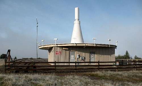
If it is not too foggy, you can see a strange looking white conical structure about 1.25 miles away to the northwest. That is your first goal. The old road kind of meanders around the top of Upper Table Rock but in about 1.75 miles you finally get to the white conical structure. This structure is an FAA facility used by the Rogue Valley
Airport to guide planes in for landings. Don’t get too curious about this facility because it has video surveillance and with all the terrorist paranoia now, you may just end up in Gitmo sharing a cell with a member of the Taliban.
The old road across Upper Table Rock has not been used in years, but there are still plenty of mud holes to avoid. I wouldn’t wear tennis shoes up here in the winter because you will get your feet wet. In the spring when the wildflowers are blooming, it will still be wet and muddy in spots, but the wildflower display is striking. There is even one wildflower that grows here and no where else.
![Upper Table Rock]()
After passing the FAA facility, the road improves dramatically. FAA employees drive up this road, but they have a key to a locked gate and permission to pass through some private property on the west side of Upper Table Rock. Stay on the road for about another .25 mile as it bends a little to the south and starts descending. There is a pond on the right side of the road and before you get to it, leave the road and head directly west, across a little clearing towards some trees. Pass through these scrub oaks and then pick your way through some heavy brush. Admire the red barked old growth Manzanita bushes that are about 12 ft high here. When you pass through the brush, you enter another clear area that extends right out to the western rim of Upper Table Rock. There are several mounds that are about 2 ft higher than the regular terrain and the topo shows the highpoint on one of these mounds out by the edge of the rim. I noted the elevation on my GPS and then headed southeast about 100 yds to a spot that looked higher. My GPS indicated this spot is 2-3 ft higher than the spot marked on the topo.
![Upper Table Rock]()
I looked around for any higher mounds but was unable to find any. I was satisfied that I found the highest spot on Upper Table Rock. I took a brief break to put a piece of tape on my left heal because the new boots were irritating that spot. I didn’t stay long because the views were lousy on a foggy morning. I hiked back the same way that I came. Within a mile of the trailhead I met some other hikers who were heading up. This is a popular trail even on a foggy cold winter day. The total hike was about 7 miles, took me 2.75 hours, and I had 835 ft of elevation gain.


Comments
Post a Comment