
-
 14336 Hits
-
 71.64% Score
-
 2 Votes
|
|
Trailhead |
|---|---|
|
|
38.77050°N / 105.0183°W |
|
|
El Paso |
|
|
10800 ft / 3292 m |
Getting There
Head south on Nevada Avenue (SH 115) from Interstate 25 on the south side of downtown Colorado Springs. Turn right (west) on Lake Avenue. Continue straight west on Lake Avenue towards the famous Broadmoor Hotel.At the second roundabout head south (left) on Old Broadmoor Road. Continue on this road as it changes to Cheyenne Mountain Boulevard through the Broadmoor Golf Course. Just past the golf course you will come to the intersection where Penrose Boulevard heads right, Cheyenne Mountain Zoo Road heads left and Old Stage Road heads straight.
Proceed straight on Old State Road approximately 6.8 miles past this intersection to the intersection with Gold Camp Road on the right. Continue straight (The road changes names to Gold Camp Road) for several miles until you see the Penrose-Rosemont Reservoir on your left. You will come to an intersection on the right for the 4-wheel drive Forest Road 379 (Frosty's Park Road). Turning here will take you to a trailhead for Mount Rosa and eventually to above treeline on Almagre Mountain. Avoid the urge to turn here and continue straight on Gold Camp Road.
About 7 miles beyond Forest Road 379 you will come to the intersection with Forest Road 376 on the right or north of Gold Camp Road. The intersection is well marked. Turn right and continue uphill paralleling the Middle Fork of Beaver Creek for three miles to the City of Colorado Springs reservoir system gate closure. Do not proceed past the gate as the area is off limits to preserve the city's drinking water supply.
Forest Road 376 is maintained by the City and typically is accessible by two wheel drive. There are multiple opportunities for camping along Forest Road 376.
The gate closure is just north of a four way intersection just over three miles north of Gold Camp Road. The 4-wheel drive road to the left (west) ends in Bull Park. The 4-wheel drive road to the right (east) is not recommended for vehicle traffic but passes through Elk Park, Deer Park, High Park and eventually Frosty's Park where it connects with Forest Road 376. This road, referred to as the Old Seven Steps Road on the Pikes Peak Atlas, would likely be an excellent mountain bike loop if combined with Gold Camp Road.
Destinations Accessible from the Forest Road 376 Trailhead

Almagre Mountain - 12,367'
Baldy Mountain - 12,326'

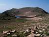
Stratton Reservoir
Sheep Mountain - 12,397'
Bull Park
Elk Park