
-
 9535 Hits
-
 76.66% Score
-
 7 Votes
|
|
Route |
|---|---|
|
|
31.72800°N / 110.8479°W |
|
|
Hiking |
|
|
Spring, Summer, Fall, Winter |
|
|
Most of a day |
|
|
Overview
 Along the South Ridge
This is a moderately long on-trail hike with a few junctions to pay attention to, capped by a short but bristly and rocky bushwhack along the south ridge to the summit. As you ascend the route, you will pass through a few distinct plant communities and wildlife is abundant. The route passes (or comes very close to) three springs: Sylvester Spring, Kent Spring and the small seasonal seep called Armour Spring. There are some fine views from the summit of McCleary Peak, but dynamite vistas also are enjoyed en route to the top including the Santa Rita crest and Pete Mountain across the canyon. The route includes a tour of the devastation caused by the 2005 Florida Fire.
Approximate Roundtrip Distance: 12 miles
Elevation Gain: 3,317 feet
YDS Class: 2+
Getting There
 Amphitheater Parking
 Trailhead information kiosk
 Signage
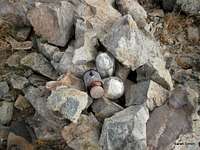 Summit Cairn
This peak is roughly 50 miles south of Tucson, Arizona. While the peak can be accessed from the more remote east side, most visitors to and residents of Tucson will access this peak from the more developed west side.
A few primary access points for this peak are available via the Madera Canyon area, accessible from I-19 on the west side of the Santa Rita Mountains, exiting at Continental and traveling toward Madera Canyon.
• Follow I-19 to Green Valley, Arizona
• Exit #63 Continental Road.
o From the exit, it is a good 12 miles to the trailhead
o Follow signs to Madera Canyon Recreation Area, they are plentiful
• Take the road to the east (if coming from northbound I-19, you will pass under the interstate)
• Keep an eye out for the plentiful signs to Madera Canyon! Don’t miss the right turn onto Whitehouse Canyon Road. You will leave the desert floor and enter the wooded canyon, heading toward the Santa Rita peaks.
Four Springs Trail:
1. Madera Trailhead Picnic Area: On the left just after the Bog Spring Campground. Paved road access.
2. Amphitheater parking area and trailhead: On the right side of the road after Bog Spring Campground (heading up-canyon), and just past the Santa Rita Lodge. Cross the road to reach the start of the trail. Paved road access. These driving directions coincide with the route description below.
3. Shortcut to Four Springs Trail: Follow the road to its very end, high up in Madera Canyon, where there are two lots, and upper and lower lot for parking. Look for the unofficial “pipeline trail” to shortcut to the trail to Kent Springs. Paved road access.
Route Description
 Route Overview
• From the Amphitheater parking lot, carefully cross the road to the east to the start of the trail.
• Hike a bit more than ½ mile on this spur trail through scrub oak and grasses to a junction marked by a large sign.
• Turn right at the junction and travel on an old road bed (now a wide trail) for about ½ mile.
• At the next junction, stay right (the Bog Springs Trail continues to the left) and travel for about 1 mile to Sylvester Springs (a square concrete structure with metal piping on your left).
• Hike another mile to Kent Springs (a round concrete and stone structure).
• At Kent Springs you will encounter a trail junction. The Bog Springs Trail (signed) heads off to the left. You want to take the un-signed Four Springs Trail uphill to the right.
• From here, the trail ascends through forests, sometimes switching back and others traversing across the slopes of the Santa Rita Crest. The trail map indicates it is only 2.2 miles from Kent Spring to Armour Spring, but I will be the first to tell you that the distance feels much longer.
• The first forested saddle you encounter below “88 Mac” sits in dense pine forest and is a nice place to rest before pushing on to the saddle near Armour Spring.
• The trail will level out at the base of the southern ridge of McCleary Peak. Note that Armour Spring is not very apparent and is not a reliable landmark.
• Leave the trail before it begins to descend and strike out on the south ridge of McCleary Peak. During our visit, occasional cairns helped to guild the way, but these little rock piles can come and go, so be prepared to navigate the scrub, cactus and rocks on your own.
• The route twists and turns over boulders, up occasionally loose scree and through tight stands of trees and scrub with cactus underfoot. With careful routefinding, the rock should not exceed Class 2+ and the bushwhacking, while tight in spots, should be readily passable.
• As McCleary Peak is the northern end cap of the Santa Rita crest, the final steps to the summit afford dynamite views of the surrounding area. Especially fine views are of Mount Wrightson and “88 Mac” to the south, Pete Mountain across the canyon and a funky view of Elephant Head. Enjoy your stay before retracing your steps.
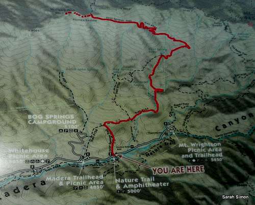
| Bushwhacking the South Ridge of McCleary Peak | ||||
|---|---|---|---|---|
 Route Map Route Map | 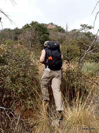 |  | 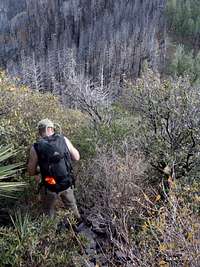 | 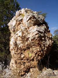 Oddity en Route Oddity en Route |
 Leave trail here Leave trail here |  Kent Spring junction Kent Spring junction |  Cairns dotting ridgeline Cairns dotting ridgeline |
Essential Gear
 Pete Mountain
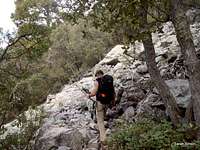 Midway up the trail
• Standard hiking equipment suitable to the season
• Sunscreen and sun protective clothing
• Plenty of water (or purification methods for drinking from the springs if seasonal conditions permit – for instance, Sylvester Spring looked drinkable during our November visit, but Kent Spring was down to a stagnant trickle).
• Long sleeves, long pants and sturdy hiking shoes will protect your body from blood-thirsty plant life during the off-trail segment.
• Map: Green Trails No 2962S Santa Rita Mountains