
-
 7922 Hits
-
 71.06% Score
-
 1 Votes
|
|
Route |
|---|---|
|
|
42.26800°N / 105.441°W |
|
|
Hike, short scramble |
|
|
Half a day |
|
|
Walk-up |
|
|
Approach
Follow the detailed directions on the main page to get to Friend Park. From the obvious Friend Park Campground, continue up the road until you see the small parking lot and the sign that marks the beginning of the trail. There should also be a box that requests a modest fee (no longer a "donation"). You can either park at this lot or at Friend Park Campground (if there's space).Route Description
After getting onto the trail, it will be relatively flat and rolling for the first half-mile or so. You will actually lose elevation just before you get to a creek crossing. At this creek, there will be a sign marking the elevation (somewhere around 7,500 feet, I believe), and a wooden bench. From this point on, the trail will be a steady uphill trek.The entire course of the hike will take place on the West side of the mountain, and the switchbacks are quite regular and predictable; just keep hiking. Much of the journey the scenery will be non-existent due to the heavy-treed trail (the mountain never rises above treeline). Once you get about 1/3 of the way up the trail, you will be able to see a cliff just to the Northwest. The top of the feature marks just about the half-way mark for the hike.
Along the way, there are several areas in the switchback that open up by the edge of the mountain providing convenient look-out points for pictures and rest-stops. You will also switchback over the creek several more times, which allows a great time to stop and fill up your waterbottles (no need to pack a surplus!).
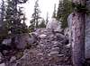
Towards the top, the trail become quite rocky (so good support in your hiking boots is nice). When you reach the rocky part of the trail, you know you are almost there. You will be pleasantly suprised when one of the switchbacks leads you out of the trees and to the apparent summit; the views will be outstanding. However, this is not really "it." Continue Northward, climbing over the boulders. There should be makeshift "steps" that help you make your way to the helicopter pad, which most climbers count as the summit. If you REALLY want to stand on the true summit, you'll have to climb up the granite chimney with the radio tower atop it.
Be sure to stay on the trail during this climb. It may be tempting to cut the trail on the way down, but doing so only damages (1) the vegetation and (2) your ankles. Also, although the switchbacks stay on the West side of the mountain, venturing off the trail doesn't necessarily mean that you'll reach the trail again below!
 |  |  |  |  |
Essential Gear
Hiking boots and appropriate clothing is necessary. Even in summer, it can get fairly cold, especially if it rains. Bring rain gear, and have sufficiently warm clothing. Sunscreen won't hurt, but you'll spend very little time in the sun during this hike due to the tree cover. As with any mountain, beware of lightning, and take the proper precautions. If you're climbing in the winter months, have warm clothing, enough water, and keep in mind that none of the snow gets sun; it will be POWDERY. Snowshoes might help, but don't rely on them to work too much magic.Miscellaneous Info
If you have information about this route that doesn't pertain to any of the other sections, please add it here. |  |
Heaton - May 25, 2009 12:44 am - Hasn't voted
Hiking feeThe word "donation" is no longer part of the fee structure. A sign threatens prosecution for failure to pay $5 per vehicle to hike the trail.
Trevor Simmons - Jun 16, 2009 12:08 am - Hasn't voted
Thanks!Thanks for the comment. This is good to know, as I haven't been to Friend Park in almost half a decade now.