
Comments
No comments posted yet.
|
|
Trip Report |
|---|---|
|
|
38.64910°N / 121.0999°W |
|
|
Aug 4, 2004 |
 To this hill (all in 24 hours)
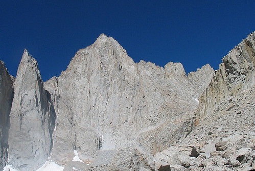
 When I left Mt. Whitney the day before, it was with a hand that had been doctored up at the Lone Pine hospital. due to a mishap I had while ascending the MR on Mt. Whitney that resulted in what I thought was a broken hand. It turned out to be a broken finger but nevertheless, I had to abort my MR effort. Totally bummed out by the bad luck, I decided to head for home since I couldn't climb anything that required the use of both hands. However, when my wife came up with the idea of doing the lowest county highpoint in the state of California, Carpenter Hill near Sacramento, that brightened up my gloomy spirit and it kinda felt right as I would be going from doing the highest county highpoint in California to the lowest one. Perfect.
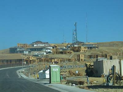
After meandering through Yosemite and the gold towns of highway 49, we eventually (my wife did the driving) made it to the base of Carpenter Hill, newly decked out in all kinds of building efforts. The hill itself was adorned with several towers and wasn't overly appetizing but ironically in the special realm of county highpointing, Carpenter Hill counted just as much as the top of Mt. Whitney since it was one of California's 58 county highpoints.
There were homes going up everywhere and access to the paved road that led up to the towers on the hill. No problem, it was easy to just sidestep around to the side of the gate and walk up the road. After 5 minutes of walking, I could see a fenced in area where the towers were but just outside the fence was a couple of large boulders that seemed to be the highest objects on the overly rounded hill. I walked over to the northern side just to make sure but it was obvious that the boulders were atop the highest area.
When I left Mt. Whitney the day before, it was with a hand that had been doctored up at the Lone Pine hospital. due to a mishap I had while ascending the MR on Mt. Whitney that resulted in what I thought was a broken hand. It turned out to be a broken finger but nevertheless, I had to abort my MR effort. Totally bummed out by the bad luck, I decided to head for home since I couldn't climb anything that required the use of both hands. However, when my wife came up with the idea of doing the lowest county highpoint in the state of California, Carpenter Hill near Sacramento, that brightened up my gloomy spirit and it kinda felt right as I would be going from doing the highest county highpoint in California to the lowest one. Perfect.
After meandering through Yosemite and the gold towns of highway 49, we eventually (my wife did the driving) made it to the base of Carpenter Hill, newly decked out in all kinds of building efforts. The hill itself was adorned with several towers and wasn't overly appetizing but ironically in the special realm of county highpointing, Carpenter Hill counted just as much as the top of Mt. Whitney since it was one of California's 58 county highpoints.
There were homes going up everywhere and access to the paved road that led up to the towers on the hill. No problem, it was easy to just sidestep around to the side of the gate and walk up the road. After 5 minutes of walking, I could see a fenced in area where the towers were but just outside the fence was a couple of large boulders that seemed to be the highest objects on the overly rounded hill. I walked over to the northern side just to make sure but it was obvious that the boulders were atop the highest area.
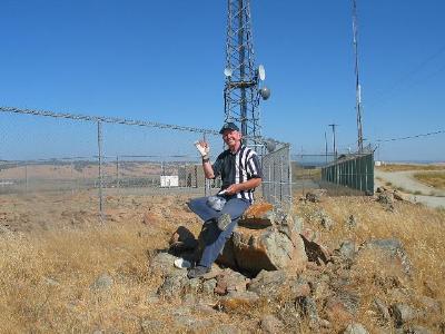 One of the boulders was slightly higher and had a benchmark planted in its center. Also at the base of the boulder with a rock sitting on top of it was a plastic tupperware container that held both a geocache and a county highpointing registers. I noticed many familiar names but didn't feel much excitement or exultation about making the summit of this not so lofty hill. Still, the views were nice although a little on the hazy side thanks to the nearness of a major metropolitan area and the resultant traffic and congestion.
I could see highway 50 (a freeway) and the Costco store below on the southwest side and some nice views toward Folsom Lake towards the northwest. No view of the Sierras were to be had this day due to the haze but on a crisp windy day, I'm sure the views would be much nicer than what I experienced.
My wife had walked up and joined me and snapped a couple pics with me sitting on the rock with the geocache container while I waved my overly dressed right side in the usual poser style.
The next day my wife and i went on to dodge logging trucks on some forest roads in nearby Yuba county as we chased that county highpoint and then later on the same day also did Black Butte (Glenn county) and Anthony Peak (Mendocino county) before ending up in a redwoods state park in northern california as we made our way home.
One of the boulders was slightly higher and had a benchmark planted in its center. Also at the base of the boulder with a rock sitting on top of it was a plastic tupperware container that held both a geocache and a county highpointing registers. I noticed many familiar names but didn't feel much excitement or exultation about making the summit of this not so lofty hill. Still, the views were nice although a little on the hazy side thanks to the nearness of a major metropolitan area and the resultant traffic and congestion.
I could see highway 50 (a freeway) and the Costco store below on the southwest side and some nice views toward Folsom Lake towards the northwest. No view of the Sierras were to be had this day due to the haze but on a crisp windy day, I'm sure the views would be much nicer than what I experienced.
My wife had walked up and joined me and snapped a couple pics with me sitting on the rock with the geocache container while I waved my overly dressed right side in the usual poser style.
The next day my wife and i went on to dodge logging trucks on some forest roads in nearby Yuba county as we chased that county highpoint and then later on the same day also did Black Butte (Glenn county) and Anthony Peak (Mendocino county) before ending up in a redwoods state park in northern california as we made our way home.