FOREWORD
I typically do not dwell on the past. I am a person who tends to look forward to the future. However, because 2012 was my most successful peakbagging year to date, I wanted to reflect on those experiences and share some of them with other people.
During 2012, I reached more summits, gained more cumulative elevation, and hiked more peakbagging miles than I ever have previously done in any single year. In fact, as a person who has an active schedule which includes family, work, and non-peakbagging hobbies (yes, those exist!), I doubt at this point that I will ever improve upon those single-year personal peakbagging achievements.
During 2012, there were many great trips and few dull moments. My peakbagging year started with a trip in which I was caught in an avalanche. My peakbagging year reached its midpoint with a trip in which I achieved a major peakbagging accomplishment. My peakbagging year ended with a trip in which I got to (finally) relax and enjoy fantastic views of a region very sentimental to me.
I was able to do peakbagging and highpointing across different regions of the USA, in the Northwest, Southwest, Northeast, and Southeast. I even summited my first peak outside of my home country. Not all of the trips and destinations were exciting, and few will probably make the list of my favorite summits of all-time, but I will view this year in its entirety. 2012 was a year during which I achieved things that only a few years ago seemed distant. It was a year I will treasure for the rest of my life.
JANUARY, NOTABLE SUMMIT TRIPS
The year did not start as planned, but if anything it was a wake-up call to always expect the unexpected. As part of a personal effort to continue exercising even during the dreary Winter months of the Great Northwest, my friend Bryan and I decided to go on a local snowshoe trip together on New Year’s Day. With what seemed like a favorable weather forecast and low avalanche danger, we chose low-elevation peaks Scout Patrol Peak and Little Saint Helens as our destinations. The two peaks seemed like good options because snow-covered forest roads could be used for much of the trip, with minimal shortcuts and off-road travel necessary if desired.
As we ascended a steep slope to a forest road several hundred feet above us, I stopped several times to probe the slope (as I often do on steep snowy terrain). Despite the low elevation and low regional avalanche danger forecasted, it never hurts to take a few extra moments to check slope stability. Everything seemed OK, and we made it to the top of the slope to the forest road without incident. Our trip and route were working very well for us, and we were making great time.
![Prior To Scout Patrol Avalanche]() Bryan Ascends Soon-To-Be Avalanche Slope...
Bryan Ascends Soon-To-Be Avalanche Slope...
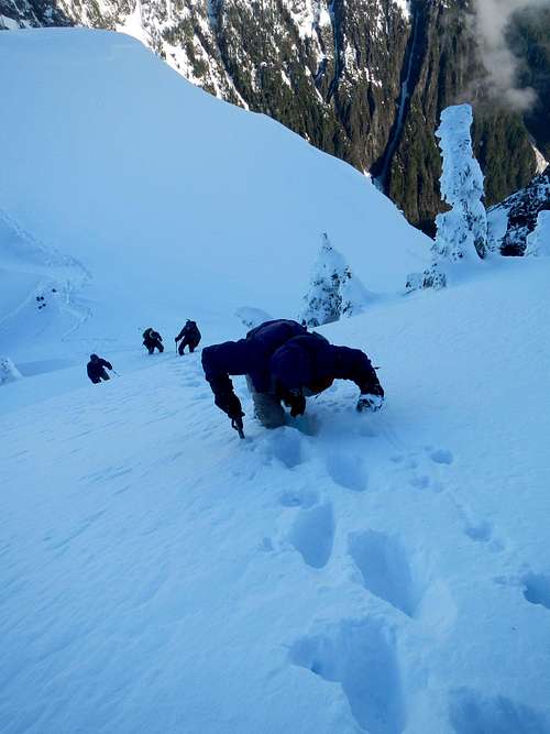
However, shortly thereafter, as we walked along the non-wind-loaded side of the road I watched as a crack quickly formed around Bryan’s feet, sweeping him down the slope. Then, without time to react, where the crack stopped its circle around him suddenly started a new crack around me. To give an analogy, my visual of the occurrence was as if snowy boogie boards were carrying us down the mountain and we were suddenly in a “wave” of sorts. Fortunately, we each remained calm and talked with each other while “swimming” on top of the slide. The minor avalanche was wide but fortunately not deep. It swept us both down several hundred feet, but except for some minor bruises we were both OK.
That evening, we worked with the Northwest Avalanche Center (NWAC) to report the incident and determine the cause of the avalanche despite our observations that danger was not imminent. But sometimes nature wins despite caution being used. The official NWAC incident report is available
online.
In the middle of the month, I organized a group to snowshoe up Arrowhead Mountain, which was my first 6000’+ summit of the year and first-ever 6000’+ summit in the month of January. At the end of the month, I visited some relatives in Arizona and used the opportunity to summit several mountains, including peaks with 2000’ of prominence and county highpoints. I was surprised to find Mount Lemmon drivable up to the gate located at 8350’, a feat which could never be acomplished in Washington. The following morning, I hiked up Harquahala Mountain, which was my favorite peak of the trip. I really enjoyed the solitude I found while hiking the peak, and the weather and scenery was much better than I anticipated.
![Mount Lemmon Summit]() At The Mount Lemmon Summit...
At The Mount Lemmon Summit...![View From Harquahala]() View From The Harquahala Mountain Summit...
View From The Harquahala Mountain Summit...FEBRUARY, NOTABLE SUMMIT TRIPS
My first summit trip in February was as part of a group of snowshoers and skiers going to Mount Angeles, in the Olympics Range. Mount Angeles is a very popular hiking destination, so I was amazed to be a part of 12 notable climbers who had never previously summited the peak. We enjoyed great weather and great views all day, and when our group reached the summit we all celebrated the birthday of one of the climbers. I created a short
video for the trip.
![Mount Angeles]() Mount Angeles
Mount Angeles![How to properly celebrate...]() How To Celebrate A Birthday...
How To Celebrate A Birthday...
In the middle of the month, I ventured to Anaconda Peak, an obscure mountain near the Mountain Loop Highway. This was not a fun solo trip, as the mixed dirt/snow-covered forest duff continually slipped beneath my feet and the weather left much to be desired. The best part of the trip was meeting a local resident who lived near the entrance to the access road, while the peak joined my “one and done” list.
MARCH, NOTABLE SUMMIT TRIPS
My first summit trip in March was a trip to Ironstone Mountain involving three other local peakbaggers. This would be my first-ever trip with local peakbagger Paul Klenke, something which I had looked forward to for some time. We had great weather and some spare time, so Paul and his friend Stefan had us do some “dumpster dive” peakbagging to finish the day’s events.
![Klenke on Ironstone]() Paul Klenke On Ironstone Summit...
Paul Klenke On Ironstone Summit...
My final summit trip of the month was a side-trip I took while visiting friends in the Tri-Cities region of Washington. I visited Washtucna Benchmark, which Paul (Klenke) had speculated might be a contender for the highest point in Franklin County, Washington. I had previously expressed to him my apprehension at such an assertion, and my findings at the highpoint area confirmed (at least to me) that Washtucna Benchmark is definitely not the county highpoint.
![Why am I here?]() Why Am I Even Here? :-)
Why Am I Even Here? :-)APRIL, NOTABLE SUMMIT TRIPS
I was a part of several fun trips in April. My favorite of those trips was a snowshoe trip I organized for Lennox Mountain, a 2000’ prominence peak located in the Alpine Lakes Wilderness of Washington. Several of the group members doubted that the route I had chosen (via Coney Creek) would be successful, but the route worked very well for us. One of the highlights of the trip was when our friend Micheal (a.k.a. “Jimbopo”) caught up to us midway during the ascent. His expedition involved arriving too late at the meetup location, then running (literally) too far off our route, and then backtracking and running (literally) up our route… and he had started on our route approximately 1.5 hours after we had! I wrote a
trip report for the experience.
![Lennox Mountain - East Ridge]() East Ridge Of Lennox Mountain
East Ridge Of Lennox Mountain![Snow Pillows]() I Call This View "Snow Pillows"
I Call This View "Snow Pillows"![Summit Group Photo]() Group Photo At Lennox Summit
Group Photo At Lennox Summit
Later that month, I also determined a new summit route for Storm King Mountain, a mid-elevation 2000’ prominence peak. I also did a solo snowshoeing trip up Crystal Mountain, near Mount Rainier, for which I worked closely with the ski resort personnel to make the trip happen and also gave me a good opportunity to try different non-emergency features of my SPOT device.
![Storm King Mountain]() Storm King Mountain
Storm King MountainMAY, NOTABLE SUMMIT TRIPS
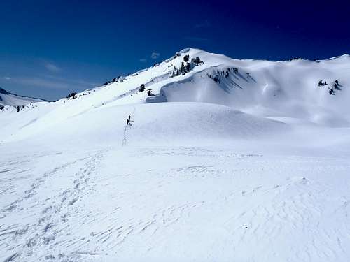
The month of May started with one of my favorite trips of the year. My childhood home was not far from Mount Index, so it had been a goal of mine for a long time to summit the peak. “Gimpilator” and I had previously attempted and failed on the peak, timing-out, and we wondered if the snow conditions on the mountain would cooperate on our second visit. We invited a solid group of climbers to join us and also had some luck. We hit the right snow conditions at the right times we needed them, and the trip was a success. “Gimpilator” wrote a brief
trip report about the experience.
![Steep Snow]() My Steep Ascent On Mount Index (Photo By "Gimpilator")
My Steep Ascent On Mount Index (Photo By "Gimpilator")![Near The Summit]() Near The Summit Of Mount Index (Photo By "Gimpilator")
Near The Summit Of Mount Index (Photo By "Gimpilator")![Summit Shot]() Our Team On Index Summit (Photo By "Gimpilator")
Our Team On Index Summit (Photo By "Gimpilator")
The month ended with a Memorial Day weekend trip to eastern Washington, some parts of which were solo and some parts of which were shared with “Gimpilator” and Paul Klenke. I was able to summit nine peaks that weekend, six of which had fire lookouts. The weather was taking a turn for the worse on the west side of the Cascade Mountains, so we were each able to accomplish a lot more peakbagging on the east side of the Cascade Mountains, as a result.
![Funk Mountain]() "Gimpilator" and Paul Klenke On Funk Mountain
"Gimpilator" and Paul Klenke On Funk MountainJUNE, NOTABLE SUMMIT TRIPS
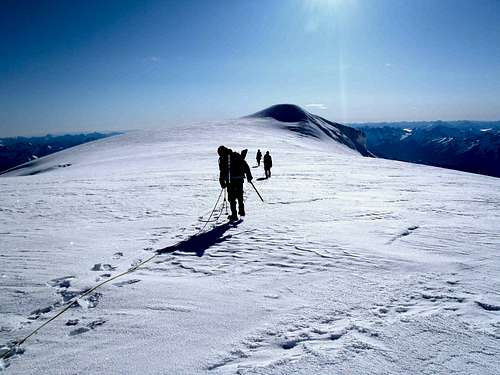
The first half of June was amongst the most frustrating times of the year for me. After nearly two months of great mountaineering weather, most of the Northwest was ravaged by lingering storms for nearly all of June. Although I was able to go out on some minor trips early during the month, I continued to wait patiently for the right weather, conditions, and mountaineering partners to join me for an attempt of my biggest goal of the year: Mount Baker.
Finally, on June 19, the weather forecast looked to be favorable for approximately the next 24-36 hours. “Gimpilator” and I quickly took the following day off from our respective jobs, assembled two other mountaineers (Joe & Jeremy), and that night began what would become a non-stop, 18-hour, 7500’+ gain trip up and down Mount Baker. We chose the Easton Glacier route, and we lucked-out with weather and conditions. Not only were we successful, it marked my simultaneous completion of the Washington County Highpoints, Washington County Prominence Points, and Washington 25-Miles Isolation lists. It also was my 100th USA peak with at least 2000’ of prominence. “Gimpilator” wrote a
trip report, and I wrote a
trip report, too. I also created a summit
video.
![Approaching The Baker Summit]() Approaching The Mount Baker Summit...
Approaching The Mount Baker Summit...![Mount Baker Summit]() "Gimpilator" And I
"Gimpilator" And I![The Baker]() "The Baker"
"The Baker"
With my major peakbagging list goals for Washington now complete, I immediately set my eyes on other goals in other regions. At the end of the month, while poor weather still plagued the Northwest (but seemed better further south), I drove to southwest Oregon to summit several county highpoints and prominence points. The most notable of those peaks was Grayback Mountain, the Josephine County highpoint, which, despite a poor-quality road and even worse weather, I summited within 1.5 hours.
![Grayback Mountain]() Steep Meadow Slopes On Grayback
Steep Meadow Slopes On GraybackJULY, NOTABLE SUMMIT TRIPS
July started where June left off… in southwestern Oregon. On July 1, I successfully summited Pearsoll Peak, the most prominent point in Josephine County. But it was a pre-hike incident, and not the hike itself, which was most memorable. I was basically chased off from a standard approach (via McCaleb Ranch) for the mountain before I even got to begin. A man at the ranch homestead did not like me being there despite a ranger previously telling me that I could be there, and even after I moved myself and my vehicle to a different location… as instructed by the man at the ranch, no less… he still sent two of his assistants to my parking area. I suspect that they were either going to damage my car or harass me, but I did not give them much opportunity to do so. I soon left and headed for another route approach (Kalmiopsis Rim Trail), which might have been a better choice, anyway. I mention the incident in my SummitPost
Climber’s Log.
![McCaleb Ranch]() Looking Down At McCaleb Ranch
Looking Down At McCaleb Ranch![Pearsoll Peak At Sunrise]() Pearsoll At Sunrise
Pearsoll At Sunrise
Later during the month, I returned to Oregon for more peakbagging. This trip was even more ambitious than the previous one. In nearly four days’ time, I had driven almost 1600 miles roundtrip, hiked over 58 miles total, achieved nearly 19,000’ of cumulative elevation gain, and summited seven peaks. All seven mountains were Top 100 peaks in Oregon and 2000’ prominence peaks. Those mountains also included six county highpoints, six county prominence points, four wilderness highpoints, and one national park highpoint. My favorite summit during that trip was Mount Thielsen.
![Mount Thielsen - West Ridge]() Mount Thielsen
Mount Thielsen![Mount Thielsen - West Ridge]() Mount Thielsen - Upper West Ridge
Mount Thielsen - Upper West Ridge
Less than one week later, to finish the month, I visited Utah and Nevada on another peakbagging trip. The trip began with a one-day, 28.5-mile ascent of Kings Peak, the Utah state highpoint and my 42nd state highpoint reached overall. I then drove overnight to Nevada, where I summited two more high-elevation peaks. I then drove back to Utah and summited Mount Nebo, the third-most isolated and fifth-most prominent point in the state.
![Kings Peak Summit View]() Kings Peak Summit View
Kings Peak Summit View![Wheeler Peak]() Wheeler Peak (NV)
Wheeler Peak (NV)![Mount Nebo]() Mount Nebo
Mount NeboAUGUST, NOTABLE SUMMIT TRIPS
After I returned back to Washington, I took some time to spend with family rather than outdoor adventures. By the middle of the month I found myself returning to a peak that I did not know if I would ever return: Mount Buckner. I usually do not repeat peaks which I have already summited, unless given an opportunity which did not present itself during the first visit(s). In the case of Mount Buckner, I wanted to help a fellow peakbagger, Adam Helman, get one step closer to finishing the Washington county highpoints. It also would give me an opportunity to visit the northeast peak of Mount Buckner, a hilltop which some people believe is the highest point of the mountain while most others (myself included) believe is just a lower sub-summit location.
Due to a late dinner commitment elsewhere, I was not able to join my friends Adam, Bob Bolton, and Duane Gilliland up to Sahale Glacier Camp during the same day as them. So instead, after dinner, I drove to the Cascade Pass trailhead in the middle of the night, slept 2-3 hours, and then met-up with my friends (much to their surprise) by 6:30 AM. I helped alleviate Adam’s concerns about a steep downclimb of a snow finger to enter Horseshoe Basin by leading the team down a different way. When Adam eventually reached the summit of Mount Buckner, Duane and I asked him if he wanted to join us for an ascent of the northeast peak. Adam, looking over towards the northeast peak and deducing (as many of us already had) that the southwest peak is the higher point, opted to not join Duane and I for an ascent of the northeast peak. When Duane and I reached our destination for the trip, our opinions had not changed; if anything, we both believed more strongly than ever that the northeast peak was the lower of the two Buckner peaks and not worth other parties visiting in the future. But that is a choice left for each person to decide.
![What I Think Of Buckner s NE Peak]() What I Think Of Buckner's NE Peak
What I Think Of Buckner's NE Peak![What Duane Thinks Of Buckner s NE Peak]() What Duane Thinks Of Buckner's NE Peak
What Duane Thinks Of Buckner's NE Peak
Near the end of the month I joined two other friends, Edward Earl and Eric Noel, for an ascent of South Twin, a 2000’ prominence peak near Mount Baker. Edward, “Gimpilator”, and I failed on an attempt two years earlier due to timing-out but we learned a lot about the terrain on that trip. “Gimpilator” made a successful second attempt less than one week prior to Edward, Eric, and I making our attempt together. His beta gave us an extra confidence boost heading into the trip.
Edward and I headed up together and met Eric soon after leaving the access road. Edward and I each bivied under the stars that night, while Eric tent-camped. We left early the next morning and arrived at the summit of South Twin approximately four hours later. The rock type on the route was excellent for scrambling; rough and solid enough to allow good grips and movement. It was a nice feeling to get another previously-failed attempt off of my “to do” list. Eric wrote a brief
trip report about the experience.
![South Twin Summit Shot]() Group Photo On South Twin Summit
Group Photo On South Twin SummitSEPTEMBER, NOTABLE SUMMIT TRIPS
September began with a 6000’ gain trip up Big Chiwaukum, a 2000’ prominence peak in the Alpine Lakes Wilderness. Rather than do the trip as an overnighter, as most people do, my friend Greg Slayden and I decided to do the 17-mile roundtrip journey as a single-day ascent. The trip involved a combination of maintained trails, open country navigation, and classic Cascade scrambling. We enjoyed great views and weather, and the jaunt was not as bad as some might indicate. Greg wrote a
trip report about the experience.
![Big Chiwaukum]() Greg Ascends Big Chiwaukum
Greg Ascends Big Chiwaukum
My biggest trip of the month, however, was a six-day trip to the northeastern USA. My main objective was to complete the five remaining state highpoints I had in that region, and also use any extra time to focus on other county highpoints. I took a “red-eye” flight from Seattle to Boston, and immediately drove west to Mount Greylock, the Massachusetts state highpoint. As I approached the summit, the weather quickly deteriorated; horrendous rain and wind was everywhere, nearly knocking me down. After Mount Greylock, I drove southwest towards Slide Mountain, the 25th-most isolated point in the contiguous USA. The weather was even worse there than at Mount Greylock but, if anything, that made my ascent quicker by taking fewer breaks. While driving north towards my next destination, Mount Marcy, I stopped at a gas station near Albany and found out from the cashier that several tornadoes had formed near the areas I had just been in earlier that day. I was shocked to hear the news yet thankful I was unscathed.
![Mount Greylock Summit]() At The Mount Greylock Summit
At The Mount Greylock Summit
I hiked Mount Marcy, the New York state highpoint, the next morning. I added nearby Phelps Mountain as a quick side-trip during my descent. I was hoping to cram in Mount Mansfield, the Vermont state highpoint, later that day but was not able to catch an early enough ferry to arrive before the entrance gate closed. As poor weather patterns continued to follow me for the entire first half of my trip, I chose not to do a long hike up Mount Mansfield. Instead, I found a preferrable car-camping site nearby and then was the first person up the mountain the next morning. I visited the summit as well as a nearby sub-summit which is the adjacent county’s highest point. The thick fog on top of the mountain prevented me from seeing any views, but that seemed to be the common theme for the first half of my trip.
![Mount Marcy - Final Slopes]() Approaching The Mount Marcy Summit
Approaching The Mount Marcy Summit![Mount Mansfield Summit Shot]() At The Mount Mansfield Summit
At The Mount Mansfield Summit
Later that day, I visited Mount Washington, the New Hampshire state highpoint. Most of my friends had said to hike to the top of Mount Washington, but a storm system and my tight schedule caused me to re-evaluate my options. I instead chose to drive to the top parking lot and hike from there. As I neared the summit, I was being hit by strong winds, rain, and hail. The temperature dropped rapidly, reaching near-freezing levels. I first took a brief visit (i.e. refuge) at the gift shop, which other people were also doing. Soon, however, I found myself being the only one choosing to continue to the true summit. The wind gusts changed from 60 MPH to near-hurricane force within 10-15 minutes.
I made a brief
video as I approached the summit, and then had to retreat to the doorway of a nearby building for a few minutes before returning to take some summit photos. Then, in an effort to try to get “perfect” summit photos, I got knocked down several times and felt like a human pinball machine. The biggest mistake I made was wearing jean shorts in the rain and wind, which further enhanced my shivers in the cold.
![Mount Washington Summit Shot]() At The Mount Washington Summit
At The Mount Washington Summit
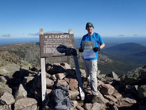
I then continued driving east to Maine, where I hiked Katahdin the following morning (September 11). Although this would be my fifth and final state highpoint in the northeastern USA and 47th overall, what I will remember most about visiting Katahdin is watching numerous completers of the Appalachian Trail arrive shortly after I reached the summit. Katahdin was hands-down my favorite hike and peak of the entire trip, and I even made a short
video.
![Katahdin Summit Shot]() At The Katahdin Summit
At The Katahdin Summit
I spent the remaining 2-1/2 days of my trip driving through Main, New Hampshire, Massachusetts, and Rhode Island, focusing on county highpoints along the way. During that timeframe, I completed the county highpoints in Rhode Island. As a personal fun-fact, my first statewide county highpoint completion was Washington, my 100th County Highpoint was Washington County in Oregon, and my second statewide County Highpoint completion occurred at Washington County in Rhode Island... I guess I am just a true Washingtonian in my heart. I also got an opportunity during the trip to visit with the Worcester Sharks AHL team's front office and pick-up a game-worn hockey jersey for my wife as a "thank you" for allowing me to go on the trip. In total, I had driven over 2000 miles and reached 18 county highpoints (including the five previously-mentioned state highpoints). It was a very successful trip.
![Holt Hill Celebration]() Celebrating Final CoHP Of Trip: Holt Hill (Essex CoHP)
Celebrating Final CoHP Of Trip: Holt Hill (Essex CoHP)
However, my favorite trip of September, and one of my top two favorite trips of the year (with Mount Baker being the other), was an ascent of Silvertip Mountain in British Columbia. Silvertip Mountain has the distinction of being the closest Canadian “Ultra” (i.e. peak with at least 5000’ of clean prominence) to the USA border, as well as being the most prominent non-volcanic peak in the entire Cascade Range. It was to be my first-ever ascent of a peak outside of the USA, and I had wanted to summit the peak for several years. I had researched several routes for the peak and even helped to organize a trip the previous year, but had to back out of the trip due to a combination of poor weather and other commitments. The people who continued with that trip ultimately failed during their attempt due to poor snow/ice conditions on the peak.
For my attempt in late September, I was accompanied by Martin Shetter, who had been on the previous year's failed attempt. But unlike the previous year's attempt on a north route with sketchy terrain, we were going to make an attempt via a more straightforward south route. In our circle of peakbagging friends, little firsthand knowledge was known about the south approach, but we were confident that our research and abilities would ultimately lead us to success.
![Silvertip Mountain]() Silvertip Mountain
Silvertip Mountain
We car-camped at our starting location and then ascended the peak the following morning. Desipte a few occasional ribbons on trees, the entire route had no trail system. To compound things further, the south approach gained a hefty 6700’ in only 3.5 miles from car to summit. Fortunately, we both had maps and GPS devices, and most of the route followed ridgelines. Upon reaching the summit, I took the opportunity to wear “Silvertips” gear and hold a “Silvertips” flag, as a reference to a Northwest hockey team. All things considered, the antics seemed appropriate for a peak sharing a similar name. Martin wrote a
trip report about the experience.
![Approaching Silvertip Summit]() Martin Approaches The Silvertip Summit...
Martin Approaches The Silvertip Summit...![Silvertip Mania!]() Silvertip Mania!
Silvertip Mania!OCTOBER, NOTABLE SUMMIT TRIPS
The first trips of October were about Bald Eagles and re-attempts. First, I summited Bald Eagle Peak, a mountain which I had failed on 2-1/2 years earlier. During the ascent, I slipped and briefly dislocated one of my shoulders during the trip, but after “popping” it back into place I continued to the summit. Several days later, I summited Bald Eagle Mountain, a peak which I had failed on 1-1/2 years earlier. Most of the route was on trails, but the final steep off-trail ascent to the summit required usage of “veggie belays” on heather and huckleberry shrubs… which had me concerned that a slip might reinjure my hurt shoulder. Fortunately, I never slipped and I successfully reached the summit.
![Bald Eagle Peak]() Approaching Bald Eagle Peak...
Approaching Bald Eagle Peak...![Huckleberries And Heather]() Huckleberries & Heather On Bald Eagle Mountain
Huckleberries & Heather On Bald Eagle Mountain
However, my most memorable trip in October was going to Orcas Island to see my friend, Dennis Poulin, complete the Washington county highpoints. He completed his goal on 10/13, a date which seemed fitting because I was the 10th completer and he was the 13th completer, as well as I was the first completer of the Washington county highpoints that year and he was the last completer. Dennis was accompanied by fellow completers Bob Bolton, Duane Gilliland, Edward Earl, and I… the largest group of previous finishers to witness a person’s completion of the Washington county highpoints… as well as several wives and Ken Russell (who was in the process of working on the Washington county highpoints list). One of my favorite moments of the trip was during our post-summit dinner, during which time Bob told the story of how he had met Dennis. I recorded a
video of the tale.
![Mount Constitution CoHP Celebration!]() Gathering Of Some WA CoHP Completers
Gathering Of Some WA CoHP CompletersNOVEMBER, NOTABLE SUMMIT TRIPS
I only took two hiking trips in November, one short and one long. The first trip of the month was at Hogback Mountain, a peak with almost 2000’ of prominence located near White Pass in Washington. The mountain is easily accessible from near a ski area, and for me I was able to make a more direct ascent route due to fresh snowpack in the area. No snowshoes were required, but it was still a 10-mile roundtrip jaunt in a remote area.
The second trip of November was definitely longer, and perhaps more notable. I drove down to Oregon for the weekend, but I found out during the trip that my wife would be meeting me at the tail-end of the trip to see the new baby of some friends in Portland. This caused me to ramp-up my peakbagging efforts with little extra time to spare, starting with the lone Oregon county highpoint I still needed in northwestern Oregon.
The first summits I visited were the Lincoln County highpoint (which has no official name) and the possible highpoint contender on nearby Saddle Bag Mountain. The access to both locations is similar, although the logging company maintaining the access roads in the area had a new rule being enforced. Non-motorized access started much further from my two peak destinations than people had experienced in previous hunting seasons, making my trip be 21 miles rather than 13 miles roundtrip. Fortunately, I had brought my bicycle with me which greatly decreased my ascent and descent times. However, I also got a lot of strange looks from hunters I passed during the trip, and those whom I spoke with were irritated with the new non-motorized access restrictions in the area. At the conclusion of the two-peak trip, I believed that the western highpoint contender (on Saddle Bag Mountain) might actually be slightly higher than the eastern contender, but I have no firm proof of that assertion and I leave that opinion for each person to decide. I wrote a brief
trip report.
![Lincoln County HP]() At Eastern HP Contender For Lincoln County
At Eastern HP Contender For Lincoln County
After finishing the two-peak county highpoint portion of my trip, I headed north and finished the day with a quick ascent up Firebreak Peak, a low-elevation (but high prominence) mountain located only a few miles from another county highpoint which I had visited only one year prior. After car-camping that night, I did an early morning hike/bike trip up West Onion Peak, the most prominent point in Clatsop County and my final county prominence point completed in northwestern Oregon. After completing my trip for West Onion Peak, I drove eastward to Portland, stopping at several minor peaks along the way which I found on my road atlas. My favorite of those minor peaks was Mount Tabor, the only volcano in the USA located completely within the boundaries of a major city (Portland).
DECEMBER, NOTABLE SUMMIT TRIPS
December started with a group trip to Red Top Mountain, a peak located in the eastern Teanaway region of Washington. Due to snow-covered roads and gated roads preventing our car from any upper access to the standard hiking routes, we opted to try a more direct off-season route via Medicine Creek. The route worked very well, as a combination of open country and snow-covered trails. Despite the snowpack, enough snow had melted in recent days that snowshoes were not necessary. Our group was rewarded with some great views at the summit, which also had a fire lookout building as an additional reward. This was our first-ever trip with a new peakbagging friend, Natasha Walker, who would soon decide to join my friend “Gimpilator” on a trip to Nepal during Spring 2013.
![Red Top Mountain]() Approaching Red Top Mountain...
Approaching Red Top Mountain...
Two days after the Red Top Mountain trip, my work sent me to the southeastern USA for a couple of weeks. During the second half of the trip I was sent to Orlando, and during the one day I had off from work during that timeframe I decided to summit several local county highpoints in the surrounding area. They were basically lame “peaks” (and I use that term loosely), but they still brought my overall total county highpoints to 145 and one of the peaks (Sugarloaf Mountain) is the 12th-most isolated point in the contiguous USA.
I finished the month, and the year, on two trips with my new peakbagging friend, Natasha. While “Gimpilator” was out of Washington for several weeks, in his absence I decided to try to help Natasha become more familiar and comfortable with snowy terrain and conditions before he returned (and especially before their trip together to Nepal). We took a snowshoe trip (including her friend Emily) to the south peak of Mount Lillian near Blewett Pass a couple of days before Christmas, during which there was 3’-5’ deep of powder snow that really slowed our progress all day. Then Natasha and I took a snowshoe trip to Tye Peak near Stevens Pass a few days before the New Year, during which I showed her some basic techniques for snowshoeing and ice axe. The trip provided excellent training for the outdoors, and would probably help Natasha gain further confidence on future trips. The Tye Peak trip had a good route, great weather, and fantastic views of terrain both near and far.
![Tye Peak]() Natasha Ascends Tye Peak...
Natasha Ascends Tye Peak...![Looking Forward to 2013!]() What A Great Year! Looking Forward To The Future!
What A Great Year! Looking Forward To The Future!
It was a perfect way to end a wonderful peakbagging year, my best peakbagging year to date.
SOME OF MY 2012 PEAKBAGGING STATISTICS
VARIOUS PERSONAL ACHIEVEMENTS:
218000+ Total Elevation Gain
500+ Miles Hiked For Summit Trips
130+ Total Summits
41 Summits With At Least 2000' Of Prominence
40 USA County Highpoints
12 States With New Summits
8 Ultra-Prominence Summits
6 State Highpoints
HIGHEST SUMMIT REACHED:
Kings Peak (UT), 13528' Elevation
LOWEST SUMMIT REACHED:
Seminole County Highpoint (FL), 130' Elevation
MOST HIKING DISTANCE (SINGLE DAY):
Kings Peak (UT), 28.5 Miles Roundtrip
MOST ELEVATION GAIN (SINGLE DAY):
Mount Buckner-NE Peak (WA), 8100'+ Cumulative Elevation Gain
MOST ELEVATION GAIN (SINGLE MONTH):
43190'+ (July)
LEAST ELEVATION GAIN (SINGLE MONTH):
7430'+ (February)
MOST SUMMITS REACHED (SINGLE MONTH):
37 (September)
LEAST SUMMITS REACHED (SINGLE MONTH):
4 (February, August, October)
TOP FIVE FAVORITE SUMMITS IN 2012:
1) Mount Baker (WA)
2) Silvertip Mountain (BC)
3) Mount Index (WA)
4) Mount Thielsen (OR)
5) Katahdin (ME)
HONORABLE MENTION:
South Twin (WA)
PREVIOUS FAILED ATTEMPTS THAT WERE SUCCESSFULLY SUMMITED IN 2012 (LISTED IN ORDER OF SUCCESSFUL SUMMIT REACHED):
1) Mount Index: Summited on May 6, Successful 322 Days After First Attempt
2) South Twin: Summited on August 25, Successful 2 Years 53 Days After First Attempt
3) Buck Peak: Summited on September 16, Successful 99 Days After First Attempt
4) Tinkham Peak: Summited on September 23, Successful 2 Years 335 Days After First Attempt
5) Bald Eagle Peak: Summited on October 6, Successful 2 Years 200 Days After First Attempt
6) Bald Eagle Mountain: Summited on October 11, Successful 1 Year 129 Days After First Attempt


Comments
Post a Comment