
-
 3332 Hits
-
 76.66% Score
-
 7 Votes
|
|
Route |
|---|---|
|
|
32.12930°N / 109.4545°W |
|
|
Hiking, Scrambling |
|
|
Spring, Fall, Winter |
|
|
Half a day |
|
|
Class 3 |
|
|
Overview
 Toward the saddle
Reaching Helens Dome from Apache Pass is primarily a pleasant desert ramble across rolling hills, through grass and over rocks with minimal brush to contend with (by Arizona desert standards). There are a few fence lines (the BLM often leases grazing rights to ranchers, though public recreational access is maintained) and the footpath you are following much of the way is actually a migrant route. Along the way you may notice camps as well as piles of discarded junk (e.g. clothing, backpacks, food rappers, beverage containers).
At the end of the route is a nice, surprisingly rugged little desert scramble to the top of the peak. Bring your desert scrambling clothes for this one. The views from the open, rocky top are completely wide-open and spell-bounding. Enjoy your time here.
Roundtrip Distance: 5.5 miles
Elevation Gain: 1,500 feet net gain (cumulative gain higher)
YDS Rating: Class 2+ - Class 3
Getting There
 Heading southeast from road
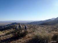 Nice, open country
Per the National Park Service, Fort Bowie Historic Park is 116 miles east of Tucson, AZ via I-10, and 227 miles from Phoenix, AZ. There are two primary access points for this peak: Through Fort Bowie National Monument or directly from Apache Pass.
• From the town of Willcox, travel 20 miles southeast on AZ 186 to the Fort Bowie turn off (Apache Pass Road).
• Continue on this graded dirt road for another approximately 6 miles to Apache Pass (un-marked except for a Fort Bowie National Historical Site sign). If you reach the Fort Bowie Trailhead, you have gone about 2 miles too far.
There is no parking area at the summit of Apache Pass. Park your vehicle in the widest part of the road, as far off the road as possible.
Route Description

• From the road, strike out through open terrain heading southeast. Stay to the northeast (left) of the fence line.
• After roughly ½ mile, ascend the first little hump, beginning the rambling, hilly terrain.
• After about another ½ mile, reach Cutoff Benchmark (spot elevation 5972). From here, Helens Dome is about 1 mile way.
• Descend down the Cutoff ridge to the saddle with Helens Dome.
• Re-ascend out of the saddle to the northeast onto the slopes of Helens Dome. The terrain becomes increasingly rocky and easy scrambling is required.
• From here, wrap around the southwest section of the peak to a small, high saddle on the southern slopes.
• Continue wrapping around the mountain in a counter-clockwise fashion until you spy a east-southeast-facing ramp and chute.
• Ascend the rocky chute, dodging yucca, cactus and shrub branches, being very careful not to dislodge rocks on your partners.
• Exit the chute on a broad eastern ledge.
• From here, enjoy an easy but steep scramble up bare rock to just below the summit.
• Take the final few steps through grass and over boulders to the top.
 Summit from NW Summit from NW |  SW from high saddle SW from high saddle |  Rocks south of peak Rocks south of peak |  Thicker brush south of summit Thicker brush south of summit |
 Heading up the gully Heading up the gully |  Final scramble to summit Final scramble to summit |  Final walk to summit Final walk to summit |  Descending from the summit Descending from the summit |
 Easy boulders on the shelf Easy boulders on the shelf |  Ramp near top of gully Ramp near top of gully | 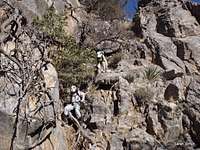 Descending the gully Descending the gully |
Essential Gear
 Gully cactus and brush
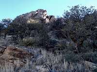 Terrain southeast of summit
In addition to standard outerwear appropriate to the season:
• Scrambling gloves (gardening gloves with leather palms do just fine)
• Clothing to protect your skin from rocks abrasions and vampire desert plants (including long pants and long sleeves, though gaiters may be useful as well).
• Sunscreen
• Hat with a brim
• Abundant drinking water and salty snacks
• Large groups should honestly consider wearing helmets for the ascent of the southeast chute
• USGS Quad: Bowie Mountain North
• Planning Map: Coronado National Forest | Douglas Ranger District (U.S. Forest Service)