
-
 5237 Hits
-
 76.66% Score
-
 7 Votes
|
|
Route |
|---|---|
|
|
32.68280°N / 110.322°W |
|
|
Hiking |
|
|
Spring, Fall, Winter |
|
|
Most of a day |
|
|
Overview
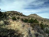
 Heading toward our goal
This route leverages a combination of well- worn trails, a twisted maze of braided cattle trails, and some easy bushwhacking with good line of sight. Note that many of the trails used to reach the foot of the ridge to China Peak are not marked on Coronado National Forest maps and are poorly maintained. Some are marked with signage, but the signs are faded and in general disrepair.
This is an outing to rely on your navigational skills and not on existing trails that may or not exist where indicated on the map, nor on semi-official or unmaintained trail markings. The route is rolling and indirect as it weaves in and out of drainages on its way to the peak, taking in fantastic scenery on the east side of the Galiuro Mountains.
Roundtrip Distance: 12 miles
Net Elevation Gain: 2,300 feet
YDS Rating: Class 2+, due to easy scrambling on final push to summit
 Faded old signs Faded old signs | 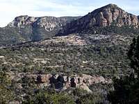 Scenery to south Scenery to south |
Getting There
 China Peak from the South
First, get yourself to the town of Bonita, Arizona. Bonita is about 31 miles north of Willcox, AZ via Fort Grant Road. From Bonita, continue north on Aravaipa Road for approximately 19 miles to the Deer Creek Ranch Road (FS 253). Take a left on FS 253, following it for 8 1/2 miles to the trailhead. At the time of my visit, the Forest Service was erecting a brand new privy at the trailhead.
To reach the trailhead, high clearance is strongly recommended. 4x4 is nice-to have in dry conditions and a must-have in wet conditions.
 Leave the fence line Leave the fence line |  Cross country toward saddle Cross country toward saddle |
Route Description

• Leave the trailhead following the old roadbed beyond the gate heading southwest.
• After roughly a mile of easy travel in the shade of large trees, come to the Deer Creek Cabin and spring.
• Ascend the hill behind the cabin to gain a gentle ridge before dropping into Oak Creek.
• Ascending back out of Oak Creek, the trail begins hugging the north-facing slopes, rolling in and out of drainages.
• Use special caution when rounding point 6334 not to get suckered by cattle paths to the northeast out onto the welcoming meadow.
• China Peak will be to your due north, but a deep drainage prevents direct passage to the southern slopes of the peak.
• Near the crest of the ridge to the south-southwest of a the peak, a trail that may be marked as 278 descends to Sycamore Creek. Do not follow this. Instead, follow a faint footpath that does not appear on most maps northwest across this broad ridge, first descending to a gentle saddle at approximately 6,100 feet, then re-ascending toward point 6286.
• From this gentle savannah/plateau, China Peak is directly to the northeast.
• Depart the footpath clinging to the fence-line and travel cross-country toward the peak. Descend gentle to a saddle immediately below and to the southwest of China Peak. Then ascend the rocky southwestern ridge of the peak.
• A little easy scrambling and cholla navigation brings you to the rocky summit complete with a summit register and amazing views of the Pinalero Mountains across the valley.

 Preparing to leave footpath Preparing to leave footpath |  Rock and grass, western ridge Rock and grass, western ridge |
Essential Gear
 Relaxing on China Peak
In addition to standard hiking gear appropriate to the season, bring plenty of water (water sources are scarce in the Galiuro Mountains) and sun protection. Also, some hikers may find scrambling gloves useful on the short and easy scramble over a angular blocks to the summit and to push through brush.
 Last few steps to summit Last few steps to summit |  China Peak summit China Peak summit |