|
|
Route |
|---|---|
|
|
36.03120°N / 51.93710°E |
|
|
Mountaineering |
|
|
Summer |
|
|
A few days |
|
|
Hike+Scramble |
|
|
Getting There
See "Getting There" on Main Page.Route Description
Please refer to the map of Dokhaharan Massif or the Detailed Map of Central Alborz for the below discussion. Having the 1:50 000 map (See the “Maps” section of Introduction to Central Alborz) can add much more detail. You will need Sheet “6362 II Baladeh” for Chapakro and Sheet “6462 III Nomar” for Nomar Village.Place............Elevation(m).......Distance (Km)
Nomar Village....2150...............Zero
Lehra Saddle.....3650...............14.5
Base Camp........3470.................1.5
Chapakro...........4260.................5
Total........................................21 Km
The village of Nomar is also known as Nomarostagh.
At the village of Nomar (2150 m), the stream splits. The W/NW branch goes up the slopes of the 3888 m Nazer Peak. The Southwestern branch is known as Daryook. A 4WD road follows the Daryook branch 3.5 Km to end at a place where a foot bridge crosses the stream. Hike or drive this road and then cross to the left (southeastern) side of the stream. Follow the trail less than 2 kilometers to reach a flat grassy plateau known as “Daryook Plain” (2350 m) where the stream makes many branches. The western branch is known as “Paniri” River and goes toward the Shekar Leghas Peak. You will need to follow the southern branch and will have to cross the branch to its west side. This can be done fairly easily but will get you wet above your knees.
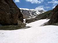
Follow the well-established trail to a place called “Chehel Cheshmeh” (2800 m) where water pours down the side of the mountain onto the trail. At around 2950 m you will reach another relatively flat area. Kaoon Peak will be directly in front of you to the west and the Lehra Peaks will be visible as rocky summits to the south. Lehra Pass sits between the Kaoon and Lehra Peaks. Do not mistake the other saddle between Kaoon and Siyaroo Peaks for Lehra. Follow the trail to reach the 3650 m Lehra Saddle where Chapakro and its neighbors come into view. Identify the pointy Chapakro Peak to the east of the twin summits of the Dokhaharan Peaks Look for the valley that separates Chapakro from the Sesang Peaks farther east. You will eventually need to go up this valley.
At the Lehra Saddle, you could descend a drainage south to reach the Sesang River but a better option is to head west and go through another saddle north of Point 3662 m and south of Kaoon Peak to reach another drainage that can be descended down to the banks of the Sesang River (3470 m). Set up your base camp at the junction of the stream that drains the valley between Chapakro & Sesang Peaks with Sesang River.
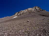
Head S/SW going up the valley that goes between the Chapakro & Sesang Peaks. You will go through a short segment of narrows. Follow a faint trail on the NW side of the valley. Be ware that if you choose to follow the stream at the bottom of the valley, you will encounter at least one very steep area. To your right, you will first see Peak 4020 m and Erim Peak (4160 m). As you go higher, Chapakro will come to view as a conical peak with a rounded top. Continue up the valley until you reach the 3990 m saddle between Chapakro Peak & Sesang #1 Peak.
 Steep Snow Steep Snow |  Erim, 4020 & 3768 Erim, 4020 & 3768 |  Steep Snow Steep Snow |
The slopes of Chapakro above this saddle will be steep and rocky. Do not attempt to climb it from here instead turn west and bypass the rocky summit of Chapakro on its southern slopes (No difficulties here) and head for the 4150 m saddle between Chapakro and East Dokhaharan. You can then turn back east and follow the ridge-top to the summit of Chapakro. Some scrambling is required here.