
|
|
Route |
|---|---|
|
|
39.06145°N / 106.53325°W |
|
|
Mountaineering |
|
|
Summer |
|
|
Most of a day |
|
|
hike |
|
|
Overview
As mentioned in the main page, the trail that supposedly goes from Mc Nasser Gulch Trail to the ridge-top between Ouray Peak and Point 12743 ft, does not seem to exist. The route mentioned here will take you up steep grassy slopes. Obviously, when snow is present, danger of avalanche on this slope will be high.Getting There
Directions to Mc Nasser Gulch Trailhead:From Independence Pass on Route 82, drive 9.3 miles east (or 14.5 miles west from junction of Routes 82 and 24) to the “South Fork of Lake Creek Road” (FR 391) (the parking area for La Plata Peak Trail is in the same area). This is a dirt road that is rough with many pot holes but is technically a 2WD road.
Turn south onto the South Fork of Lake Creek Road. At 2.8 miles go straight (right). After 3.3 miles you will reach the junction of “Mc Nasser Gulch Road” (FR 394). This is your trailhead (10760 ft)
4WD can continue another 1.1 miles to road closure at 11360 ft.
Route Description
All distances are per my GPSPlace…..……….Elevation (ft).…Distance (miles)
Trailhead……….10760………….zero
Rd Closure……...11360…………1.1
Saddle…………..12420………….0.72
Star Mtn……...…12941…………1.70
Total……………………………..3.52 miles
From the trailhead you will not have any views of Star Mountain. Hike up the Mc Nasser Gulch road through a forest of Pine and Aspen trees.
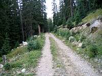 Mc Nasser Gulch Rd |  Mc Nasser Gulch Rd |
After 1.1 miles, you will reach a gate (GPS Coordinates 39:02.823 North, 106:33.364 West). Motor vehicles are not allowed beyond the gate. You might have views of Ouray Peak to the northwest. You will see steep grassy slopes on your north side. Leave the road and hike directly up the grassy slopes. The forest here is patchy and you can avoid entering it by hiking up the grassy areas.
 Grassy Slopes | 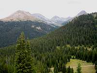 View from Grassy Slopes | 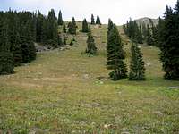 Grassy Slopes |
Soon you will be above the trees and will find yourself at the bottom of a big bowl between the slopes of Ouray Peak to the west and Point 12743 ft to the east. Hike up the steep grassy slopes of the bowl to reach the 12420 ft saddle.
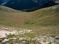 Bowl |  Bowl |
Once on the saddle, you will turn east and follow the ridge-top to reach the summit of Star Mountain. There are a few high points on your way. The first one is Point 12743 ft which has talus covered slopes with rocky outcroppings on both sides of it. It is much easier to follow the grassy ridge-top to the summit of Point 12743 ft than to try to traverse its slopes on either side. The next high point is Point 12620 ft and it can be traversed on its southern and eastern slopes.
 North Face of Point 12743 ft | 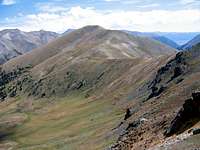 Star Mountain from near Point 12743 ft |