
|
|
Route |
|---|---|
|
|
38.92440°N / 106.32°W |
|
|
Scramble |
|
|
A long day |
|
|
Class 3 |
|
|
Approach
Begin by first summiting Mount Columbia from North Cottonwood Creek Trailhead.
 |  |
Route Description
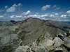
From the summit of Mount Columbia, head northeast and descend a rocky slope into the basin north and east of the ridge connecting Columbia with Harvard. This connecting ridge is called Rabbit Ridge and should not be attempted. Instead, head down the steep rock pile and aim for a wide grassy slope on the opposite side of the basin.
You will need to cross numerous rocky gullies and descend to about 12,600 feet in elevation. Contour around the basin at 12,600 and find the grassy slope going up the southeast side of Harvard. You can look for a line of willows to guide your ascent. Climb up this grassy slope and then veer left to the top of a jagged ridge.
Once on Harvard's SE ridgeline, pick up a faint trail and scramble along the ridge. The route has some cairns but is not well marked. Plan on spending 3.5-4 hours to get from the top of Columbia to the top of Harvard. Descend Harvard along the obvious standard route into Horn Fork Basin. It's 6.5 miles from there back to the North Cottonwood Creek trailhead.
This route is roughly 16 miles with an elevation gain of 6,000 feet. A long day but you get to bag two collegiates.
Essential Gear
No technical climbing required. The Harvard Ridge is at most a class 3 scramble. There is one slippery spot with some exposure.
Miscellaneous Info
If you have information about this route that doesn't pertain to any of the other sections, please add it here.