
|
|
Route |
|---|---|
|
|
36.27878°N / 51.06038°E |
|
|
Mountaineering |
|
|
A few days |
|
|
Hike |
|
|
Getting There
Directions to Narian VillageFrom the western parts of Tehran, Drive the Tehran-Qazvin Freeway 40 Km west to the town of Karaj, continue roughly another 60 Km to a village called Abyek. A little on the west side of Abyek, take the exit to “Ziyaran-Shahrak”. Drive this road 40 Km north to reach Shahrak (or Shahrake Taleghan). This town sits at the bottom of the Taleghan (Shah Rood) River Valley. Continue the road past Shahrak heading east 15 Km to reach the village of Jowestan. Here, right goes to the village of Gateh Deh and left to Narian. Take the left road and drive 8 Km to a split in the road. Left goes to the village of Parachan and right to Narian. Take the right road and cross the bridge then drive a few kilometers up a saddle and then down to reach the village of Narian
Route Description
All Distances are per my GPSPlace……………….Elevation m………Distance Km
Narian………………2350………………Zero
Stream Split…………2500………………3.2
Spring……………..2750…………………2.8
Saddle……………3820……………….…5
Zarrin Kooh……….4198…………………1.3
Total……………………………………….12.3 Km
.
From the village of Narian, Zarrin Kooh will not be visible but the 3975 m Siahleez Peak will be seen to the north.
In the village of Narian (elevation 2350 m), follow the street on the left (west) side of the stream uphill and exit the village then follow the trail north. For about 3 Km, the trail will continue at the bottom of the valley going through village farms and orchards.
 Above Narian Above Narian | 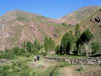 End of Farms End of Farms |
After 3.2 Km, the stream splits. You will have to cross to the east side of the stream just before it splits. This will get you wet at least knee high. You will then follow the trail up a very steep section 150 or so vertical meters up until you reach the top of one of the two very long southwestern ridgelines of Zarrin Kooh. It becomes much less steep here and the summit of Zarrin Kooh will come to view at the far end of the ridgeline.
 Stream Split Stream Split |  Top of Ridgeline Top of Ridgeline |
At an elevation of 2750 m, you will reach a spring (the locals called it “Chashneh Kharan”). The 4065 m Alaneh Sar Peak will be in view to the north/northwest.
 Alaneh Sar from the spring
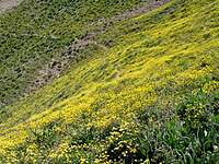

Following the ridge-top trail will get you to a somewhat open and flat area at an elevation of 3150 m. When we were there in early June, the place was covered with large fields of yellow flowers. From this area, you could potentially follow the ridge-top all the way to the summit but we chose to follow the trail down the slopes to cross a large valley between Zarrin Kooh and Siahleez Peaks. The bottom of this valley was covered by a very long snow field.
 Snow Field
You will then follow the trail up the slopes below the 3820 m saddle between Zarrin Kooh and Siahleez Peaks. The trail fades away at an elevation of 3500 m and the slopes become very steep. Hike up the slopes to reach the saddle. At the saddle, you will head southeast and follow the ridge-top to the summit.
 Summit from Saddle