Page Type Page Type: Trip Report
Date Date Climbed/Hiked: Nov 1, 2009
Activities Activities: Hiking
Seasons Season: Fall

Preliminaries

Shelley at the TrailheadShelley at the trailhead

Kaupo GapNear Kaupo Store

I had originally planned to do this hike on a visit to the island of Maui in 2006. By beginning the hike from the Mokulau Cemetary this would ensure an elevation gain of 10,023 feet on the 19-mile trip to the summit. But while locating the cemetery/church proved relatively simple, the actual beginning of the trail at the trailhead ±2.25 miles up the road was virtually impossible to find. After futilely scouting around for the trail, I finally gave up the idea and settled for the lame effort of a drive-up to the summit.

So for a return trip to Maui in 2009 I carefully researched and GPS'ed the actual starting point of the trail prior to arrival, and once again carefully scouted out the trailhead the day before my planned attempt of the hike. The careful preparation proved to be unnecessary, as the beginning of the trail now sported a newish-looking set of trail markers to help guide the way.

The Hike

Ascending Kaupo GapAscending Kaupo Gap
Shelley in Kaupo GapShelley Resting in Kaupo Gap
Kaupo GapKaupo Gap
Kaupo GapLooking West
Shelley in Kaupo GapShelley in Kaupo Gap
Haleakala CraterHaleakala Crater
Haleakala SummitHaleakala Summit

Hike day began with a 3:30 am wakeup and a 4:00 am departure from our west shore condo, which put us at the trailhead just after 6:00 am. Shelley dropped me off on Highway 31 just east of Kaupo, and proceeded up to the trailhead, while I made the ±0.5 mile run down to the shore so I could begin the hike at sea level. I stuck my hands in the ocean just to make it official, then began the 10,000 vertical foot climb with the sky just beginning to lighten. I continued back to highway 31, then ran most of the way up to the 'official' trailhead where Shelley was waiting to begin her portion of the hike.

Although the sun was not yet up it was now fully light as we began hiking up the trail. We elected to carry our headlamps, which turned out to be a good move as we descended well after dark. The first 3.5 miles of the trail climbed quite steeply, following the vague tracks of jeep roads. We passed a number of cattle grazing on the hillside, and were also passed by a truckload of angry locals performing farming chores, but we saw no other hikers on the trail. At ±3.5 miles from the official trailhead, the trail crossed into Haleakala National Park, and became more 'trail like' in appearance.

Approximately 5.5 hours into the hike at ±6200 feet, we entered the Haleakala crater and soon arrived at a trail junction, with the right branch leading to the Paliku Cabin (camping area) and the left branch heading west ±10 miles towards the summit. Shelley had not planned to go for the summit, thinking some silly idea that people go to Maui in order to sit on the beach and drink cocktails. We figured this was a good spot for her to wait for me, so we took a few minutes to go over contingencies and eat a few snacks. Then setting a 3:00 pm turnaround time, I headed off towards the summit.

The first few miles remained relatively flat, so I was able to make good time across the crater floor. The summit was visible but still remained a deceptively long way off. It felt good when I finally started to climb and chip away at the ±3000 vertical feet still remaining. As I headed towards the summit I encountered the first hikers of the day, and with ±1500 vertical feet still remaining I noticed a horse team carrying a load of tourists back towards the summit. I finally caught the horse team just as they exited the crater at the top of the Sliding Sands trail. The riders didn't appear too pleased at having been caught by a hiker, but the horses didn't seem to care.

Exiting the crater all that was left was a 260 vertical-foot walk up the road to the summit hut. Apparently there are people who actually drive right to the summit. It was noticeably colder and windier as I covered this final stretch. I entered the summit hut at 2:50 pm, 10 minutes short of my turnaround time. Not that I would have noticed, since I'd not looked at my watch since leaving Shelley 4 hours ago in the crater below.

A nice woman from Arizona took my summit photo, then it was time to begin my descent. I returned to the Sliding Sands trailhead, then made the short walk to the Visitor Center to fill my water bladder before beginning the long hike back. Shadows were growing long as I descended into the crater, and I ran the entire way back to the rendezvous point with Shelley. By the time I reached her the sun had descended for the day, but we were still able to get in a few miles of descent before finally resorting to headlamps.

The descent was somewhat challenging despite our headlamps and a nearly full moon, but we managed to remain on trail most of the time. Entering brushy terrain on the final ±0.5 miles to our vehicle we began to see the glowing eyes and hear the crashing brush of wild pigs, so it was a relief to finally see our vehicle in the moonlight. It was somewhat tempting to just hop in the vehicle, but I knew that to officially complete a round trip I needed to descend the 1.5 miles back to highway 31 by foot. So Shelley proceeded down to 'highway' 31 in our rental car, while I followed on foot. I tried to run, but my now blistered feet only permitted a brisk walking pace.

I finally plopped back into the vehicle at 10:05 pm, just short of a 16-hour round trip. I now had a full week to do some of that beach sitting and cocktail drinking that Shelley had spoken of.

A Few Stats

Date: November 1, 2009
Start Time: 6:10 am
Finish Time: 10:05 pm

Ascent Time: 8:34
Summit Time: 0:21
Descent Time: 7:00
Total Time: 15:55

Trailhead Elevation: 0 ft.
Summit Elevation: 10,023 ft.
Round Trip Distance: ±38 miles
Elevation Gain: 10,023 ft.

Post-Summit CelebrationCelebration Luau


Comments

Post a Comment
Viewing: 1-6 of 6
Matthew Van Horn

Matthew Van Horn - Nov 9, 2009 7:35 pm - Voted 10/10

A good band name

would be "The Angry Locals"-
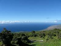
Dam dude, that sounds like a fun 38 miles. I'm going to save up so I can go do that hike. I like how you keep it pure going from sea to summit to sea.

Joseph Bullough

Joseph Bullough - Nov 10, 2009 3:45 pm - Hasn't voted

Re: A good band name

Thanks for the great vote Matt. I'll save my map and notes for you so you'll have something to go by when you get around to this one.

Moogie737

Moogie737 - Nov 12, 2009 5:29 pm - Voted 10/10

Just another day at the office, right?

Joe, nice going. In some ways I wish I had not read this report, because it makes me even sadder than I was before, to think that I had the chance and didn't go with you. Great adventure for you and another awe-inspiring trip for others to emulate.

BrysonCJ - Dec 8, 2010 10:46 am - Voted 10/10

Campworthy

Thanks for the report, Joe. I'm headed to Maui in January and am seriously considering this ascent. I'd like to save the descent for the next day, though. How would you recommend acquiring the required 3-day permit and whatnot to camp at the top? Seems like I'd have to get the permit the day before, use that first day for a small dayhike on the western side, and then complete the real ascent and descent from the eastern side over the remaining two days. Thanks again for sharing!

Dmitry Pruss

Dmitry Pruss - May 31, 2011 4:42 pm - Voted 10/10

Thanx for the inspiration Joe

finally done it myself too. A variation actually. Swam @ Polo Beach at midnight & ascended the East Ridge in the cool of the night, glimpsed the peaks of Big Island over the sea of clouds at sunrise, jogged along the Skyline to the top, and then descended through the famous redwood forest (no sea coast in that direction and so "only" 7300 ft down, but the misty woods are 100% worth it). 8 hrs up and 4 down, 42 miles per my GPS.

cakewalk - Feb 25, 2015 1:02 am - Hasn't voted

Kaupo Gap Trail

There are probably not many people hiking this trail and it shows when you're there. In certain places the trail is not well marked nor maintained. However I still do recommend this sea to summit hike because however difficult it may be, it's awesome to do things like this and the park is beautiful. National Geographic has a Trails Illustrated topo map of the park that you can buy for $12 at the park headquarters when you register at Kipahulu. We lost the trail shortly after the start, approximately .5 mile from the trailhead. It cost us a lot of time and anguish as we had limited time to get to Paliku campsites before dark. It looks and sounds like others have made our same detour and why wouldn't people when the trial marker posts point you in the wrong direction! Here is how to avoid the detour we made (getting lost) on 2/18/15: When you get to a switchgrass area after approximately 1/4-1/2 mile there will be a marker post on the left side of the trail telling you to go straight up a hill. Don't do that: TAKE A RIGHT INTO THE SWITCHGRASS for a short bit and keep looking to your left and take a left up into a treed area to continue on the trail. I had limited resources so I did what I could to mark the trail. I put two substantial pencil arrows pointing to the right on the marker post. I also put lava rocks and limbs across the wrong paths in two places and I built three cairns to hopefully guide someone the correct way. I did beat down a trail, beat back some of the switchgrass and I broke some branches that were impeding the trail. This won't last long, as everything is growing out of control and there are cattle, pigs, wild dogs, horses and deer making all sorts of other trials. A small amount of routine maintenance would make a huge difference here but yea right, that's gonna happen! Have a nice hike!

Viewing: 1-6 of 6

Parents 

Parents

Parents refers to a larger category under which an object falls. For example, theAconcagua mountain page has the 'Aconcagua Group' and the 'Seven Summits' asparents and is a parent itself to many routes, photos, and Trip Reports.

HaleakalaTrip Reports