
|
|
Route |
|---|---|
|
|
38.67688°N / 106.43778°W |
|
|
Mountaineering |
|
|
Summer |
|
|
Most of a day |
|
|
Hike |
|
|
Getting There
Directions to the beginning of Tincup Pass Rd in St. Elmo:From the town of Buena Vista drive 8 miles south on Route 285 to a place known as Nathrop and then turn west onto Route 162. Drive this road 16 miles to the ghost town of St. Elmo (the first 10 miles are paved and the rest is a well graded dirt road). In St. Elmo, go thru “Main Street”, turn right and cross the bridge to the north side of Chalk Creek. Then make an immediate left and continue to the west end of town.
Route Description
All distances are per my GPS.In St. Elmo, head west and hike or drive (4WD) Tincup Pass Road. The lower parts of the road go through an aspen forest.
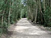
Tincup Pass Road
After 3.65 miles, you will see signs for a trail (Trail 1439, the northern end of Alpine Tunnel Trail) on the south side of the road. Get off of the road and start hiking this trail. You will first go through a beautiful meadow.
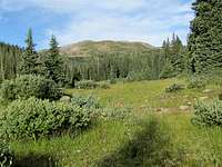
Meadow
The trail then goes into a pine forest, makes many switchbacks and goes up a slope.
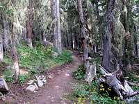
Forest
As you go above tree-line, Peak 12885 ft comes to view.

Peak 12885 ft
The trail goes through a 11940 ft saddle at the base of the summit of Peak 12885 ft. You can choose your own way up the grassy eastern slopes of Peak 12885 ft.

Peak 12885 ft