
-
 3067 Hits
-
 75.81% Score
-
 6 Votes
|
|
Route |
|---|---|
|
|
38.78110°N / 106.0332°W |
|
|
Hiking |
|
|
Spring, Summer, Fall, Winter |
|
|
Half a day |
|
|
Overview
 NW along FS 300
In dry conditions, with the right combination of 4x4 and driver, this route can be just a short skip up a slope to the summit. However, in summer, this area is dry, hot and sun-baked and crowded with other visitors. For quite and solitude, I recommend a visit in the snow season. However, the actual mileage and elevation gain of this route can vary greatly depending on seasonal snowpack as well as recent snow storms. Be prepared for a flexible adventure!
The below stats assume “longest case scenario,” parking at the Ruby Mountain Trailhead.
Roundtrip Distance: 9 miles
Elevation Gain: 1,925 feet
YDS Class: 1
Getting There
 FS 300B signpost
 FS 300B in the snow
From Johnson Village on US 24/285, take Chaffee County Road 301 southbound.
Take Chaffee County Road 300 east toward Ruby Mountain Campground. The Ruby Mountain Trailhead is roughly .2 miles past the campground.
After a heavy snow or if you do not have a high-clearance 4x4, you may need to park here. The rest of the directions may be followed on foot or by 4x4, depending on conditions.
Route Description

• CR 300 initially switchbacks through steep-ish, Piñon hillsides before leveling out somewhat and straightening to enter the Bald Mountain Gulch.
• About 1 mile beyond the trailhead, you will reach the Forest Service boundary. From the boundary, continue on FS 300 for approximately 2 miles to FS 300B.
• Follow FS 300B as it switches back up the southeast side of Bald Mountain.
• Roughly mid-way through the ascent, the road will fork to the left. Take this left fork to wrap around the west side of the peak. (Note that if you continue on the main road, you can still reach the summit.)
• The dirt road cross the southern ridge of Bald Mountain then enters a broad clearing sort of like a mini-bowl.
• Not long after entering the bowl, notice a steep two-rut trail directly ascending the upper western slope of the mountain. Take this to the summit!
 West toward the Sawatch West toward the Sawatch |  Up the western slope Up the western slope | 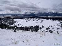 Descending the western slope Descending the western slope |
Essential Gear
 FS 300B in the snow
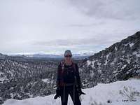 At one of the switchbacks
• A high-clearance 4x4 if you wish to drive closer to the mountain.
• Hiking gear and outerwear appropriate to the season.
• Plenty of water – this area is very dry.
• Trails Illustrated #129: Buena Vista | Collegiate Peaks
• Colorado Atlas & Gazetteer by DeLorme
 Sunshine and warmth lower on the route