
-
 6247 Hits
-
 72.85% Score
-
 3 Votes
|
|
Route |
|---|---|
|
|
42.59513°N / 0.82732°E |
|
|
Mountaineering, Scrambling |
|
|
Spring, Summer |
|
|
5.4 (YDS) |
|
|
PD+ |
|
|
III |
|
|
Overview
The full ridge of Besiberris is climbed from the summit of Besiberri Nord, and you must see this route to approach to this point. The inverse itinerary it's very hard because the step-crossing of Bretxa Sallés (in descent you can make 2 rappels, but the ascent is very complicated) and it's better the easy descent to Pas de Trescazes after Besiberri del Mig (and not the chimneys of II of Besiberri Nord).The itinerary is very long for one day, 12 or 13hours (4h to Besiberri Nord, 5h or 6h the ridge, and 3h to the descent). It's possible the camp for the night but it's difficult to find a good place to the tent. Actually the old Hut of Bretxa Peyta don't exists (attention: it appears in old maps).
For this reasons generally this route is climbed actually in 1 day and it's only for good traineds mountaineers with some of experience in rock-climb of grade III and use of rope in rappels.
The most classical route is the ridge between Besiberri Nord to Besiberri del Mig (the part most spectacullar) but generally the Besiberri Sud is climbed as well, leaving the edge of the ridge climbing across its East face. A final climb to Comaloforno and Passet is possible but then the route goes up to 15hours... I write a little about this climb if you want make this.
Getting There
See the main page to approach to Estany de cavallers and Besiberri NordRoute Description: Beggining in Besiberri Nord (PD)
 Sketch Ridge Nord-Mig
 Descent (I)
The route begin in the summit of Besiberri Nord (3015m, see the link to the normal route, PD)
We descent across the south ridge bordering the great blocks of stone, it's an easy itinerary but exposed, with the use of the hands in some points (grade F), to reach the Brecha Oliveras (2935m).
Brecha Oliveras-Brecha Sallés (PD+)
 Wall (II)
 Wall (III)
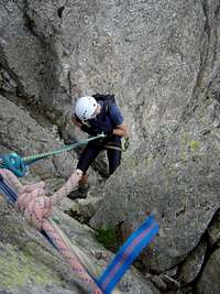
In the exit of the gap we find the first obstacle, it's a short chimney vertical of II to reach a short wall of 4 meters of III (It's a good place to use the rope for the people with less experience). After the wall we get the channel of left side to reach the edge of the ridge.
Under some aiguilles we leave the ridge and following a narrow path we descent for the west flank of the ridge. After a short walk we ascent now to reach a little rocky terrace over the Bretxa Sallés (attention to the cairns) where you'll find some places to tie the rope for the rappel.
Brecha Sallés-Besiberri del Mig (PD+)
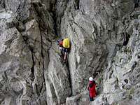
First rappel: 20 meters, good wall vertical. After a short walk-up of 15 meters we find the second place to tie the rope in the second rappel, 10 meters over a cracked chimney with difficult places to put the foots.In the Bretxa Sallés (2925m) we go across the exit of a little wall of II+ or III- to reach a confuse itinerary of chimneys, walks across narrow paths, channels of stones... ever in west face with a maximum of I+, with some exposed places (great fall). Finally we reach a wide channel of free stones (be carefull with the people and te fall of stones) to arrive, across a zig-zag between the rocks, to the summit of Pic Simó (3002m). In this point the complications are over. A short walk up to Pic Jolis (3003m) and an easy descent (I+) bring us to the very wide col of Pas de Trescazes (2909m). You can leave the route and descent if you want in this point (It's not possible leave the ridge before of this point)
 First Rappel First Rappel |
 Full Rappel Full Rappel |
 Second rappel Second rappel |
 Second rappel Second rappel |
|---|
Besiberri del Mig-Besiberri Sud (PD-)
We leave the ridge and the two big aiguilles of south and we walk for the path in east side (left) to reach the bottom of the Besiberri Sud (3030m). The chimney of II is the last obstacle to this summit. It exists another easier but longer route walking to a small gap at South of the summit. This access normally has snow in the first weeks of summer. From this small gap the route is easier (F.).From the summit we descent across the west face in a little path to the small gap in the ridge to Comaloforno. In this point you can to descent to trailhead.
The shortest descent from this point is across the Estany Gelat and Paso del Oso
Besiberri Sud-Comaloforno (PD-)-Passet (PD+)
The access it's possible bordering the ridge for both faces. The east face has a channel with hard slope and the west faces some rock-climbs. The last part with the ridge of II is the same to reach the summit of Comaloforno (3033m).After a descent in a path of west face (right) we reach Brecha Passet. The access to the big wall (tower) is easier in right side across some chimneys of II to reach the final ridge and the summit of Punta Passet (3002m). The climb of the wall of the tower is harder (III).
We need two rappel to return to Comaloforno and the channel of stones of S-SW to descent.
The shortest descent from this point is across the Estany Gelat and Paso del Oso