Contribute  Loading...
Geography Parents  Loading... Routes
| Gamsanger   | 
| Page Type: Route Location: Bavaria, Germany, Europe Lat/Lon: 47.42717°N / 11.19183°E Route Type: Hiking, Mountaineering, Scrambling Season: Summer, Fall Time Required: Most of a day Difficulty: Small exposed trails, UIAA I
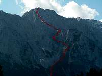
| Route Quality: | | |  | Loading...
| Page By: Lukas Kunze Created/Edited: Aug 31, 2010 / Aug 31, 2010 Object ID: 656101 Hits: 490  Loading... Page Score: 87.15% - 6 Votes  Loading... Vote: Log in to vote |
Overview | General: | 923-2298m, exposition N/NW, marked and sometimes exposed trails and scree fields/unsecured easy climbing (UIAA I) | | Effort: | About 1350m 4h | | Power: | 3 - exposed trails/UIAA I | | Psyche: | 2 - Belaying not needed | | Orientation: | 2 - well marked but the final scrambling slope needs some care |
This is the standart route up to Obere Wettersteinspitze and well marked. Although the route is not too difficult and climbing never exceeds UIAA grade I, a fall at some places may be fatal. Additionally you have to be careful since the rock is quite brittle.Getting ThereFollow one of the forrest roads or trails starting at Mittenwald to Lautersee and further up to Ferchensee. Before reaching Ferchensee lake a trail parts to the left (south) with a sign "Franzosensteig" and "Obere Wettersteinspitze". Follow the signed trail into the forrest until you reach a crossing with signs. One trail leads up to the Franzosensteig one further up to Obere Wettersteinspitze and one down to Ferchensee (this trail is rather steep and I recommend it for descend but can be used for ascent as well).Route DescriptionFollow the marked trail which gets steeper quickly. Shortly after the parting of Franzosensteig you get out of the forrest and up to the first rock step. This rock step is not difficult and has some iron cables securing it.
After the rock step the trail leads to a scree field below the steep wall up the Gamsanger saddle. The scree field is bypassed on the right side and the trail leads up the steep and higher second rock face. The trail is good and well marked but quite exposed on some places and includes some easy scrambling. The trail tops out at the Gamsanger saddle, a broad grass plateau which is a perfect place for a break before scrambling up the final slope.
Follow the trail to the south towards the small rock band wich is easily climbed on the right (west) side. Above that a small scree field leads up to the final slope which is easy UIAA I climbing. The route is well marked and is fun to climb. Shortly before the summit you reach the summit ridge and the last part is directly on the ridge where climbing is a bit more difficult but secured by an iron cable. | |
|  Rock wall up to the saddle |
|  Final summit ridge |
|  Trail to the saddle |
|
|
|
Essential GearHiking gear is sufficient. If you want to make sure bring a helmet since rockfall caused by uncareful people above you can hit you. Images
|