
-
 2600 Hits
-
 76.66% Score
-
 7 Votes
|
|
Route |
|---|---|
|
|
46.70493°N / 7.45058°E |
|
|
Download GPX » View Route on Map |
|
|
Hiking |
|
|
Spring, Summer, Fall |
|
|
Half a day |
|
|
Medium hard hike up |
|
|
Overview
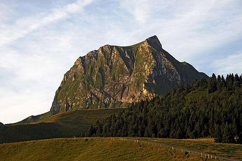
Gantrisch from the N, from the trailhead
Here, I will describe both routes on Gantrisch, the eastern and the western one. They have the common upper part (by the SW ridge) and can be nicely combined into a round tour. The tour can be done in any direction. The only reason that we did it clockwise was, that we were parking above the road pass, from where you naturally go up towards Obernuenene.
This round tour is due to a high starting point only a nice half day tour. The scenery on it is very nice: sharp mountains, rock structures, steep grassy slopes full of flowers, wide panoramas. We have to overcome only some 600 meters of altitude difference, but on the round tour there will be some small ups and downs. Count for the ascent good 2 hours and for the descent a bit less than that.
Up till the summit rocks the ascent is easy. By the Swiss Hiking Scale it is all the time T1 and T2. The upper part of the SW ridge is however steep and the last 50 meters of it the terrain is rocky, a bit exposed and requires some more care. There the difficulty rating is T3, and a short section of it is also protected by a lose cable.
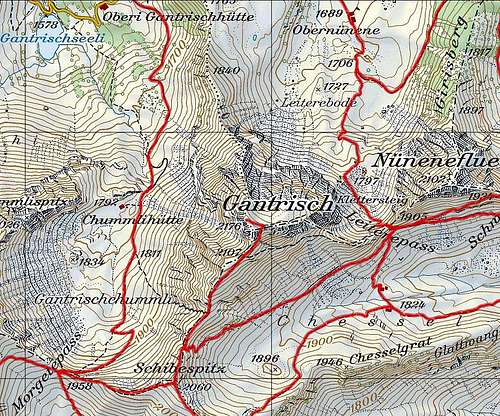
Route by sections: Wasserscheidi (1600 m) - Obernuenene (1689 m) - Leiterepass (1905 m) - saddle on the SW ridge (2020 m) - Gantrisch (2176 m) - saddle on the SW ridge (2020 m) - Schibespitz (2060 m) - Morgetepass (1958 m) - Chummlihuette (1792 m) - Gantrischhuette (1510 m) - Wasserscheidi (1600 m). See also the GPX track in the header!
Getting There
See the parent page of Gantrisch how to get on Wasserscheidi road pass! You start the tour on the big upper parking place, 1600 m.
Route Description

On Leiterepass

On the SW ridge

Descending by the W side
From the parking place you continue by the mountain road, here already closed for public traffic. In a S-SE direction you soon reach the huts of Obernuenene and from there continue in the S direction in the valley end. On some 1800 m you notice the inscription for ferrata entry - right of the path, on the entry rocks. But you continue in the same direction and in a few comfortable, a bit steep turns, the path soon brings you on Leiterepass. Nice views towards the south open there, and towards the east, the sharp peak of Stockhorn is catching your eyes.
From Leiterepass the summit of Gantrisch is still seen as a wild, steep tower. There the shortcut trail starts - it crosses the steep southern slopes to the upper part of the SW ridge. We haven't done it, but the trail looked used, even if it must be weak, and exposed. The inscription on the plate on Leiterepass however shows on the opposite direction. The marked path descends a few meters first towards the east (away from the summit) and then turns towards the W-SW. Now we cross the whole southern slope of Gantrisch, only slightly gaining altitude. left below is Chessel alpine pasture. In some 20 minutes we reach the distinct saddle on the SW ridge of Gantrisch, 2020 m.
From the saddle 2020 m the route on top is all clearly seen. It goes mostly by the ridge or immediately below it, on the S side. Nice grassy slopes host a good path wich only towards the end becomes steep, narrow and exposed. After from the right the shortcut joins us, the path starts going steeply up. We need to overcome the rocky section by an easy climb directly up. It's still only a hike-up, on some places we use hands and also a quite lose steel cable helps us. After some 50 meters we already exit on the small summit plateau (you wouldn't expect it there!). From the right, the exit path comes from ferrata. The summit is just a minute or two away, on the left side.
We return from the summit first on the saddle 2020 m, and then continue in the same direction on the rounded grassy bump of Schibespitz, which hosts some kind of abandoned military bunker. By a grassy slope we descend on the other side, the broad Morgetepass is just 100 meters below. There we turn right, across the main ridge, and start descending towards the north. A comfortable path brings us soon down on nice alpine meadows. We pass Chummlihuette, later we can even extend the tour, deterring left towards Gantrischseeli (lake). In any case we must get down to the lower Gantrischhuette, from where we take a path through the woods up on the parking place.