
-
 11360 Hits
-
 77.48% Score
-
 8 Votes
|
|
Route |
|---|---|
|
|
38.80950°N / 104.9418°W |
|
|
Hiking |
|
|
Spring, Summer, Fall, Winter |
|
|
Most of a day |
|
|
Overview
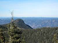
 Stove Mountain from #667
This route leverages existing Forest Service trails and social trails to take in two high Teners very close to the comforts of Colorado Springs. It includes a mix of steep social trails, undulating maintained trails and steep bushwacking up mountain slopes. Hikers on this route will take in a treasure-trove of local Colorado Springs scenery and even be treated to some historical highlights on the way including cabin ruins and mining tunnels.
Getting There
 Looking southwest from the trail
 UN 8130 and sunset
• From I-25 in Colorado Springs, take US Highway 24 (Cimarron Street) west to 21st Street.
• Head south on 21st Street, which turns into Cresta Road, for roughly 3 miles.
• Turn right on Cheyenne Boulevard.
• At the fork, follow the road to the right onto North Cheyenne Canyon Road.
• Follow North Cheyenne Canyon Road west as it ascends the canyon toward Helen Hunt falls.
• Continue past Helen Hunt falls up the switchbacks to the end of the pavement.
• Park in the large gravel parking area on your left.
 Cameron Cone from Mount Garfield
Route Description: Approach
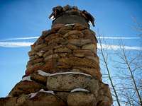 Chimney of Loud's Cabin
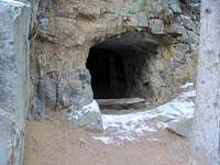 Mining adit along trail
From the large gravel parking lot, pick up the social trail up the gully heading north. This social trail begins not far past the barricade / gate at the western edge of the parking lot.
• Head steeply north up the drainage on this rustic trail for approximately one half mile.
• The social trail will intersect near the top of a ridge with Trail #667 (Jones Park Trail).
• Follow #667 for about one mile along a ridge, then dropping into Bear Canyon.
• Cross Bear Creek and head west on #667 toward Jones Park.
• Continue past the intersection with #662A* for about another half mile through Jones Park.
• Keep a sharp eye out for a social trail heading north into the drainage containing Loud’s Cabin.
• Follow this surprisingly solid social trail for a bit more than a mile, passing Loud’s Cabin and a waterfall, to the saddle between Mount Garfield and Mount Arthur.
 Loud's Cabin setting
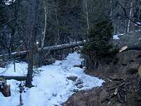 Very icy trail #667
The route gets a little sketchy at times, especially as it by-passes the waterfall in slippery Pikes Peak granite. Just keep an eye out for an existing footpath and an occasional cairn. The cairns increase in frequency as you approach the saddle.
*Per SP user cftbq, this trail is also signed as 668.

Route Description: From the Saddle
 Looking down the social trail
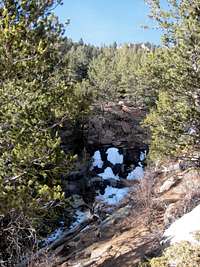 Icy waterfall in gully
Mount Garfield: Ascend Mount Garfield via its steep, heavily timbered eastern slope. About 300+ feet of vertical gain in a quarter mile is required to reach the summit, which is marked by an iron rod and an old metal summit register. Enjoy fantastic views from a bare outcrop on the northern end of the summit area.
Mount ArthurFrom the saddle, a short and rocky quarter mile and 225 or so feet of elevation gain stand between you and the summit of Mount Arthur. Ascend the rocky western slope of Mount Arthur. Many outcrops may look like the summit, but don’t be fooled. The highpoint is marked by an old snag that has been carved with names of summitters and a glass jar for a register. Naturally, the highpoint of Mount Arthur is the point furthest away from the saddle with Mount Garfield.
 Mount Arthur summit register
 Mount Garfield summit register
Essential Gear
 North-northwest from the trail
 Sunset on a lovely day
• Trail map (Trails Illustrated #137 (Pikes Peak, Cañon City) would meet most needs)
• Compass
• Sturdy hiking boots
• Snowshoes or skis after a heavy snowfall
• Water and snacks
• A camera to save memories of the high country views
• First aid kit
• Other standard backcountry essentials