
|
|
Route |
|---|---|
|
|
40.26100°N / 5.1811°W |
|
|
Hiking |
|
|
Spring, Summer, Fall, Winter |
|
|
Most of a day |
|
|
None (Class 1) |
|
|
Page optimized for a screen resolution of 1280 x 1024 pixels
Overview
This route reach La Mira and Peña del Mediodía, the two higher and outstanding summits of the eastern section of Central Gredos, a monotonous, rounded and width divide that goes from Circo de Gredos to Puerto del Pico. The North slope is smooth, cut by long ample ravines (that here are called Gargantas) between cleared hills. This route goes by two of these ravines, the two northern normal routes to both summits, linking them through a panoramic ridge walking.Easy route of medium distance and elevation gain, it consists in walking by trails and roads. Its appeals are to be attainable to anyone, to pass by beautiful and quiet environments and to visit two summits with some renown. It only has a critical point, that is to locate and follow carefully the cairns that mark, in Garganta de los Conventos, the only way to go down avoiding the rocky steps that cut its waterhead.
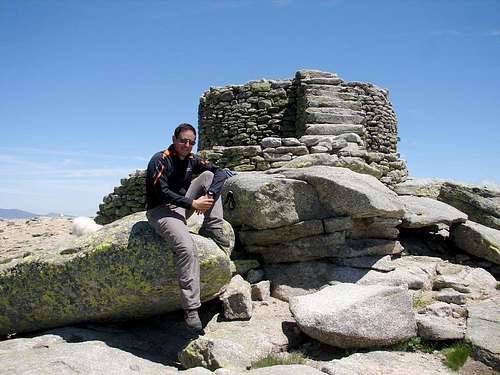 On La Mira summit.
I recommend to do the full circular route, as exposed, but you can only climb La Mira by Garganta de los Conventos or Peña del Mediodía by La Covacha, returning by the same way in both cases.
Technical details:
* Elevation gain: Approximately 1,100 meters.
* Minimum / Maximum Height: 1,520 ms / 2,343 ms
* Time: About 5h30, altogether, not counting stops.
* Difficulty: None. The only rugged and steep section is signalized.
* Done for the last time: July 13, 2008.
Getting There
Hoyos del Espino is 175 kms away from Madrid. To get there by car, you can see the most convenient route from your point of departure in the Michelin website. This is the most advisable mean to get there because to walk 5 kms by asphalt is needed to reach the trail where the route begins. Another option is take a bus in Madrid or Ávila; the company is CEVESA, phone (00 34) 91 539 31 32.From that village, take a road that, signalized to La Plataforma or Circo de Gredos, leaves to the town entrance, in front of a monument to the mountain goat. After about 5 km, when passing a little high ground, there is a dirt road closed with iron gate to the left and opposite a small esplanade where 8 or 10 cars can be parked. It’s time to walk!
Route Description
Itinerary: Road to La Plataforma - Garganta de la Covacha - Puerto del Peón - Peña del Mediodía - Puerto del Peón - La Mira - Garganta de los Conventos - Garganta de la Covacha - Road to La Plataforma. Map taken from Editorial Alpina, sheet "Sierra de Gredos", 1:40,000.
1.- The ascent: Garganta de la Covacha
Cross the gate and take the trail previously mentioned (see getting there section). It is marked as AV-PR-18 with wooden stakes with white and yellow signals. After a while, the road loses altitude to entry into Garganta de la Covacha (Small Cave Ravine) and follows it, gaining height very gently. There is a multiple crossing a little confusing next to a hut; following the stakes, go to the right. Soon after crossing a dry river, the road becomes footpath but remains clear and cairns appears beside the stakes. Going along the ravine, gaining height gently, the path reaches the waterhead. Garganta de la Covacha trail.
 Garganta de la Covacha waterhead.
After crossing the bed, the trail climbs a steeper slope, drawing diagonals, to reach Puerto del Peón (Spinning Top Pass), which Northern side is a grassland with small pools. The rock that gives name to the pass can be seen on the top.
 Garganta de la Covacha seen from the top.
 Last meters to reach Puerto del Peón.
Upon reaching the pass, left the road, that cross it to continue toward the south, and search on the left a footpath which follow the divide toward the northeast, among the bushes and rocks, and it’s marked with cairns. When gaining height, you can see Galayos and La Mira at your back. Soon, the path passes a high ground, marked with a big elongated stone placed upright, from where the summit of Peña del Mediodía (Noontime Rock) appears across a broad landing.
 Looking back while climbing to Peña del Mediodía.
 Peña del Mediodía summit.
The main appeal of this mountain is to be a good viewpoint; as you can see in the following link to a 360º interactive panoramic view from summit. But in photos below you have a couple of samples.
 View to SW: Cabezo del Cervunal and La Mira.
 View to South: Río Tiétar Valley.
2.- The ridge: from Peña del Mediodía to La Mira
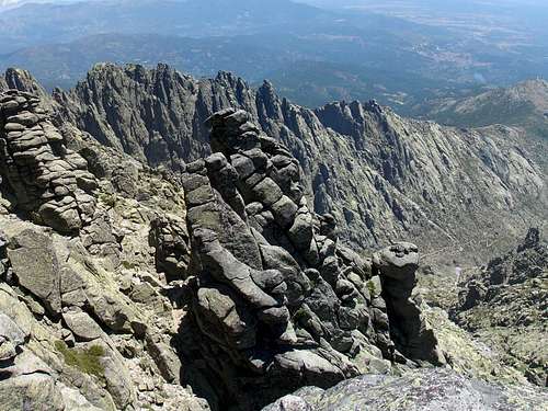
Since the ascent has been short, we can prolong the route with a second summit: La Mira. To reach it, nothing easier: just come back to Puerto del Peón and then follow the divide footpath further west. When reaching a rocky and narrow section, called La Tarayuela, you can choose between two options. The first and easier is bordering on the right (N), following the path through the waterhead of Hoya del Cura (Priest Hollow), a small ravine. The another, less easy (not difficult) but more beautiful, is to go ahead by the ridge, scrambling a little occasionally to pass some rocks. Another advantage of the ridge option is that don't loose height. La Mira beyond Puerto del Peón.
 Peña del Mediodía and ridge of La Tarayuela (footpath to the left).
Where the ridge return to be broad, the footpath comes back to the divide. Following the abundant cairns, you will pass by a landing where there is a spring, the only green touch on that arid environment, and some ruins. From there only overcome a wide rocky slope remains to reach La Mira (The Sight), whose characteristic turret will have been visible for some time.
 Last slope to La Mira summit.
 The spring seen from near La Mira summit.
Seeing its name you can think that this summit is a good viewpoint… and you don’t mistake, as can be seen in the following link to a 360º interactive panoramic view from summit.
 To the Southeast: Garganta de la Apretura.
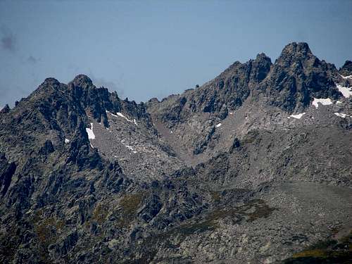 To the West: Almanzor.
3.- The descent: Garganta de los Conventos
To return, we can come back to Puerto del Peón and descent Garganta de la Covacha by the kmown way. But there is another easy option, by a different, lonely and beautiful path. First, go back on your steps until the path leaves the divide to encircle the mountain by the left (N). Passing over Garganta de los Conventos (Convents Ravine), look for some cairns to the left (NO), that mark the better way to descent a steep drop, leading to the right the easternmost watercourse feeding this ravine. There really is no path here and the rocky and steep ground is somewhat uncomfortable to walk but to use the hands is no needed. Find and follow the cairns is important here to avoid rocky steps. If you don’t find the cairns in the beginning, you have to look for in the right (E) end of the circus, near the hill that limits it by that side but leaving to the left bank of a small stream. Garganta de los Conventos from the top.
 Pools in Garganta de los Conventos.
When reaching the green landing where several streams joint, follow down the little valley. Cairns will take you by one or another bank, searching better passage but is possible to walk anywhere, on a ground alternating meadows and rock slabs. In its medium section, the ravine is a small tube with grassy hillsides limiting a watercourse that makes a pool after another (excellent place to take a long break after effort... and, in summer, to bring a towel is recommended!). Finally, Garganta de los Conventos joints Garganta de la Covacha; crossing by rocks the modest course of the lat one, you will meet the road to Puerto del Peón. Take to the left (NW) and follow down to return, by known places, to the point of departure.
 Garganta de los Conventos meets Garganta de la Covacha.
Essential Gear
Apart from the towel above mentioned, no technical equipment is required.Only the adequate clothes and other individual elements (sticks if you want, ice axe & crampons or snowshoes in winter, etc.) for medium / high mountain hiking in temperate areas.
External Links
Regional mountain weather forecast: Spanish government weather agency.If you don't understand completely the text on this page or you want to practice another languages or simply you are a little eager, you can find the original issue in Spanish in the website Pirineos3000.com
(La versión original en español de esta página se encuentra en Pirineos3000.com)