
|
|
Area/Range |
|---|---|
|
|
30.32000°N / 79.58000°E |
|
|
Hiking, Mountaineering, Trad Climbing, Ice Climbing, Big Wall, Mixed, Scrambling, Skiing |
|
|
Spring, Summer, Fall, Winter |
|
|
Introduction
Being from India, and having done many treks and climbs in this region prompted me to make this page, so that other fellow climbers can take advantage of this information.
This page attempts to provide information on the Garhwal region of the Himalayan range, which falls in the state of Uttar Pradesh, in India. Garhwal District is a former district of British India and later of the Indian state of Uttar Pradesh. it has been divided into the present-day districts of Chamoli, Pauri Garhwal, Tehari, and Rudraprayag.
It is considered a haven for mountaineers, with the Nehru Institute of Mountaineering, one of the premier mountaineering institutes, based in one of its towns.
Overview
In the words of Dr. T.G. LONGSTAFF, a seasoned traveler, and mountaineer, who first set foot on the summit of Mt. Trishul.
"I still believe that Garhwal is the most beautiful country in all Asia. Neither the primitive immensity of Karakoram, aloof domination of Mt. Everest, the softer Caucasian beauties of the Hindu Kush or any of the many other regions of Himachal can compare with Garhwal. Mountains and valleys, forests and Alps birds and animals, butterflies and flowers, all combine to make the sum of delight unsurpassable elsewhere. The human interest is stronger than in any other mountain region of the world, for these anciently named peaks are written of in the earliest annals of the Indo-Aryan Race."
Undoubtedly the center stage of the Indian Himalayas is formed by Garhwal. Garhwal, the land of many garhs, or forts, has been closely connected to the people of India since time immemorial. The Garhwal Himalayas seem to embody a mystical truth beyond the common precepts of man, a quality that has attracted sages and pilgrims alike for countless centuries. The peaks of Garhwal have not only aroused a sense of awe and eternity but also inspired great metaphysics and poetry. It is the birthplace of Hinduism's two most holy rivers - the Ganga (Ganges) and the Yamuna. Here lie the char dhams -- the four Himalayan shrines -- which have attracted Hindu pilgrims for ages. Every stone in the Himalayas is said to have a sanctity of its own, every hill-top a divine aspect and every stream a profound holiness.
In Garhwal, great peaks like Kamet,
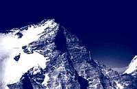
Trishul and Nanda Devi rise majestically, separated by some of the mightiest rivers of northern India.
The crowning glory of Garhwal is the beautiful Nanda Devi

, whose twin summits tower over 25,000 ft above sea level. It is these awe-inspiring peaks, the mighty rivers, the beautiful valleys and meadows, and the legends and stories associated with all of the above that make Garhwal so special.
Occupying center stage in the Indian Himalaya, are the towering ramparts of the Garhwal Himalaya. Great peaks like Trisul, Kamet and Nanda Devi stand girdled by the mighty rivers that water northern India. Garhwal is the birthing ground of the holy Ganga, it's two feeder streams, the Alaknanda and the Bhagirathi, wend their way from west and east to join at Devprayag - the confluence of the Gods.
The great mountain of the Garhwal Himalaya, is Nanda Devi, with its twin summits peaking at a little over 25,645 feet. The massif stands alone, encircled in a vast ring of lesser peaks seventy miles in circumference. In this ring are no fewer than nineteen peaks over twenty-one thousand feet and no known break below 17,000 feet, except in the west, up the incredible gorge of the Rishi Ganga. The first successful entry into the inner "sanctuary" of Nanda Devi was made up of this gorge in 1934, after years of failed attempts. Eric Shipton and H.W Tilman entered the pages of exploration history, when they along with their Sherpa porters, became the first men to set foot in the Nanda Devi sanctuary.
The main axis of the range continues north through Dunagiri - 23184 feet, onto the Chaukhamba group, smack atop the headwaters of all the main source rivers of the Ganga. Chaukhamba, meaning four pillars, lies as a 23500-foot high mooring post for the Great Gangotri glacier to the west, the Bhagirathi glacier to the north, and the glacier systems of Bhagat Kharak and Satopanth to the east. The magnificent thirty-kilometer long ridge has four peaks in the 7,000-meter region.
Just as the Great Gangotri glacier gives rise to the Bhagirathi, so does the Bhagat Kharak and Satopanth group give birth to the Alaknanda, the other main source river of the holy Ganga.
On the banks of the Alaknanda, barely 24 kilometers from the source, is situated the holy town of Badrinath, at an altitude of 11,000 feet. Badrinath, overlooked by Neelkantha is the site where Lord Vishnu meditated for thousands of years eating just the Badri grass found here. Sometime in the 8th century, the great reformer Adi Sankara came here and decreed it, along with the other great Dhams of Uttarakhand, to be a meeting place of Heaven and Earth and consequently a site of pilgrimage.
Over the centuries as Badrinath grew in fame and repute, the number of pilgrims gradually increased. The journey was so dangerous that many didn't make it. The rigors were such that one bade a final farewell to everyone upon leaving home. The present temple was built by the Raja of Tehri in the 15th century and the town grew gradually in the intervening centuries. That is till the mid-nineteen sixties and the coming of the motor road. Pilgrim traffic has been going up in a geometric progression ever since and hundreds of thousands now pay obeisance at Badrinath, every year.
In early November the shrine closes, after elaborate rituals, and a day or so later the entire town is closed, road access being prohibited, till May the next year. During winters, because of the altitude, Badrinath gets many meters of snow and the only people left in the region are detachments of the Indo-Tibetan Border Police and Military Intelligence.
Neelkantha

has been called one of the most accessible peaks in the Himalaya, as well as one of the most beautiful. Yet, the accessibility is more appearance than fact, for Neelkantha has so far been scaled only twice, that too in an area overrun by mountaineers. The height differential between the peak and Badrinath town is 3500 meters or ten and a half thousand feet in a short interval of only 9 kilometers.
Also, as mountaineers have noticed, Neelkantha is a mountain with formidable defenses. Long pinnacled ridges, steep avalanche prone faces and unpredictable local weather conditions, have combined to turn away even the very persistent.
To the northeast, 36 kilometers beyond Badrinath, is another impressive grouping - almost on the Indo-Tibetan border with Mana

and Kamet as the principal peaks. Mana itself marks the eastern extremity of the Zanskar range and lies between the pass of the same name and the Niti pass.
Upper Garwhal is inhabited by tribals of mixed Indo-Tibetan descent. One of the more important tribes are the semi-nomadic Marchas of the Mana and Niti valleys.
Mana village, just north of Badrinath, is the last village on the old trade route to Tibet, via the Mana pass. In those days, Mana must have been a big and prosperous village, references being made to it in 1624 by Jesuit priests trying to reach the Tibetan kingdom of Guge. Inhabited by people of mixed Indo-Tibetan descent, Mana, like Milam in Kumaon, survived, or rather thrived, on Indo-Tibetan trade. The Chinese invasion of Tibet, and "inner line" restrictions on the Indian side, saw an end to the trade, depriving Mana of its reason for existence in these harsh and rarified altitudes. Today, they survive by doing menial jobs or petty retailing during the pilgrim season in Badrinath. In winter, the entire village moves down the valley, cattle and all, to wait out the winter snows.
Some 45 kilometers from its starting point, the Alaknanda meets up with the Bhiyundar Ganga. This is the route for the Bhiyundar glen, or the famed Valley of Flowers, as it is popularly known.
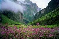
Frank Smythe, an English mountaineer stumbled upon this beautiful alpine valley while returning from an expedition to Kamet, in 1931. It was Smythe's book "The Valley of Flowers" that caught the public imagination and catapulted this remote high altitude valley in Garhwal to being the mecca for nature lovers and enthusiasts from all over the globe.
The approach to the valley is itself beautiful enough, through dense forests of oak, spruce and further up, near the tree line and above, the silver birch.
The Valley of Flowers itself, is a classic U-shaped glacial valley, molded by the periodic convulsions of the Tipra-Kharak glacier. Over the 60 odd million years that have passed since the Himalayas arose from the Tethyan abyss, the glaciers have advanced and receded many times. Since the last Himalayan Ice age, the glaciers have been receding and what we see in the Himalaya today are but mere shadows of their former selves. But nature, as they say, abhors a vacuum and what the glaciers left behind was morainic soil and debris on which took root the myriad varieties of tiny alpine flowers that, come august, turn the valley into paradise.
The attention the valley received over the decades, rebounded on it when it became the subject of environmental crusading. Its doom was paradoxically sealed when it was declared a National Park in 1981, and placed off-limits to migratory graziers. No attempt was made at the time, either by agitated environmentalists or the concerned ministry, to determine the precise positioning of these graziers and their flocks in the extremely delicate alpine eco-systems.
The surface evidence showed that sheep ate up vegetation and so, obviously, the solution is simply to ban the sheep. In the case of the Valley of Flowers, the ban resulted in the baby being thrown out with the bathwater. What has happened over the last decade and a half is simply the invasion by a tenacious weed by the name of Polygonum, and since the sheep, which had a liking for it, were so conveniently removed, it has swamped the more delicate alpine flowers which made the valley famous.
The tall plant, with numerous pink flowers, shorn of its natural predators, is tough and has great regenerative capacity. Thus unsurprisingly, weed control measures have met with little success. Instead the pastel hues of the alpine meadows have given way to large, broad patches of pink as the ever-expanding Polygonum elbows aside the smaller and more delicate varieties of alpine flowers that so charmed Smythe and generations since.
The ministry of Environment needs to rethink the situation in terms of grazing, not only for the Valley of Flowers, but also for relevant and non-intrusive Himalayan policy planning in the future. For example, in the Valley of Flowers, the scenario worked somewhat like this.... The annual upward migration of the sheep takes place in May-June all over the Himalayas. At this time the Polygonum plant is a tender shoot, bigger and broader than the alpine varieties, and so proves a tasty target for the sheep. A late flowerer, Polygonum is again just in time for the return of the sheep in September, and in the past, this twice-yearly inroad was sufficient to keep their population in check.
The entire valley of the Alaknanda is rich in wildlife. The lower hills, once famous for man-eating leopards, are today too overpopulated for wildlife to be easily visible. But it's there .. barking deer and leopards, musk deer in the Kedarnath region, and as we get higher, the Snow Leopard and the Lynx. Splendid long-tailed monkeys with black faces swarm through the trees, while high above, taking advantage of the thermals from the heated rocks below, a Lammergeier can often be spotted. Practically the largest bird in the Himalayan skies, the Lammergeier or bearded vulture, has a wingspan of 9 feet from tip to tip.
Often miscalled Golden Eagle it ranges between four to twenty thousand feet. It's eagle-like appearance apart, it is a scavenger though it is often rumored to pick up small sheep and the like. Dr. Salim Ali, the fountainhead of Indian ornithology, dismisses this and calls it "a scavenger pure and simple". Trekkers will of course see plentiful Bharal
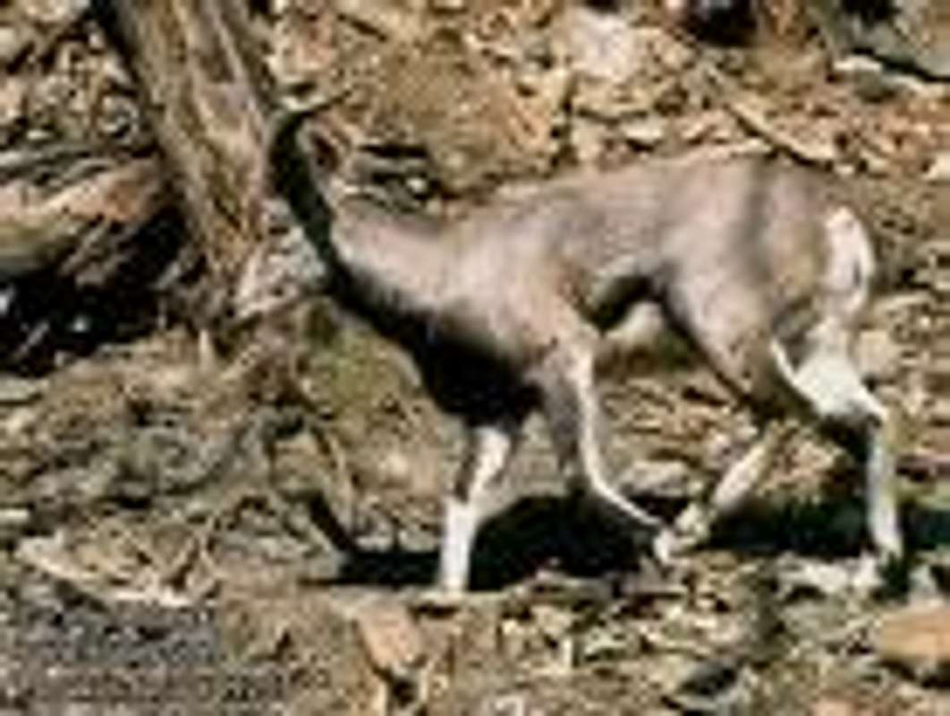
and maybe, if they're high enough and lucky enough, Ibex. The Bharal is known as the Himalayan blue sheep though strangely enough, it is neither blue nor is it a sheep.
Taxonomically it is a cross between a sheep and a goat though larger than either. Incredibly sure footed, Bharal are rarely seen by most Himalayan visitors because they prefer elevations of above 14,000 feet, only coming lower in the winter. They also seem to prefer precipitous slopes, the crumblier the better and foraging on the alpine grasses they move in herds of up to 50 or more animals, though smaller parties diverge here and there during the day.
Prominent Peaks in the Region (with hyperlinks)
•Banderpunch - 20722 ft./6316 m.
•Bhagirathi - 22493 ft./6856 m.
•Chaukhamba 1 - 23418 ft./7138 m.
•Dunagiri - 23182 ft./7066 m.
•Jogin Ii - 20800 ft./6340 m.
•Kamet - 25447 ft./7756 m.
•kedarnath - 22769 ft./6940 m.
•Nanda Devi - 25645 ft./7817 m.
•Nanda Ghunti - 20699 ft./6309 m.
•Nandakot - 22510 ft./6861 m.
•Panchachuli - 22652 ft./6904 m.
•Panwali Dwar - 21860 ft./6663 m.
•Rangrik Rang - 21499 ft./6553 m.
•Rhonti - 19718 ft./6010 m.
•Shivling - 21466 ft./6543 m.
•Swargarohini - 20512 ft./6252 m.
•Thalay Sagar - 22651 ft./6904 m.
•Trisul - 23360 ft./7120 m.
•Tsjangabang - 22165 ft./6756 m.
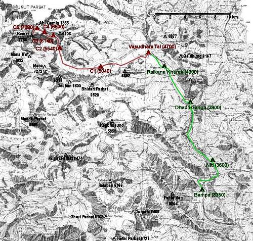
A More Comprehensive List (without hyperlinks)
The following image gives a more comprehensive list of mountains in the Garhwal region, as well as some in the Kumaon region.
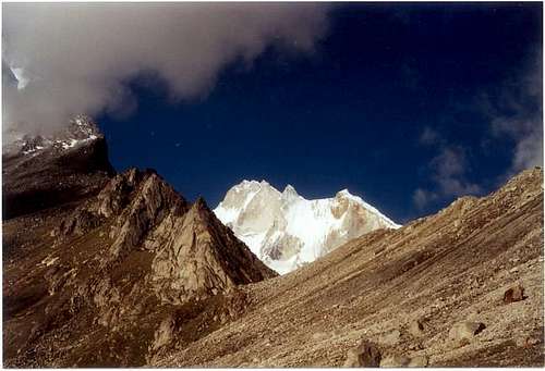
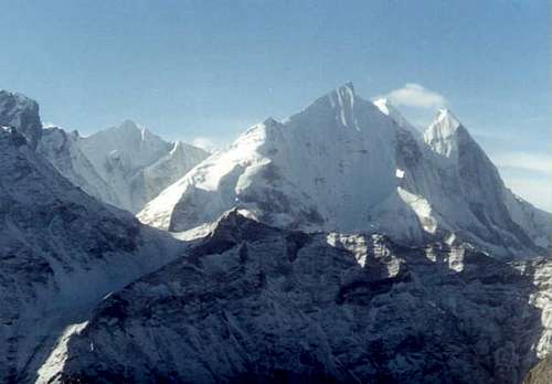
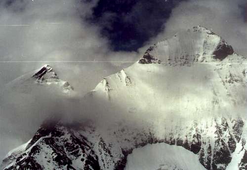
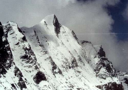
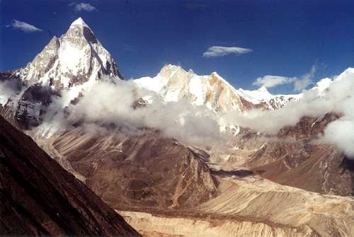
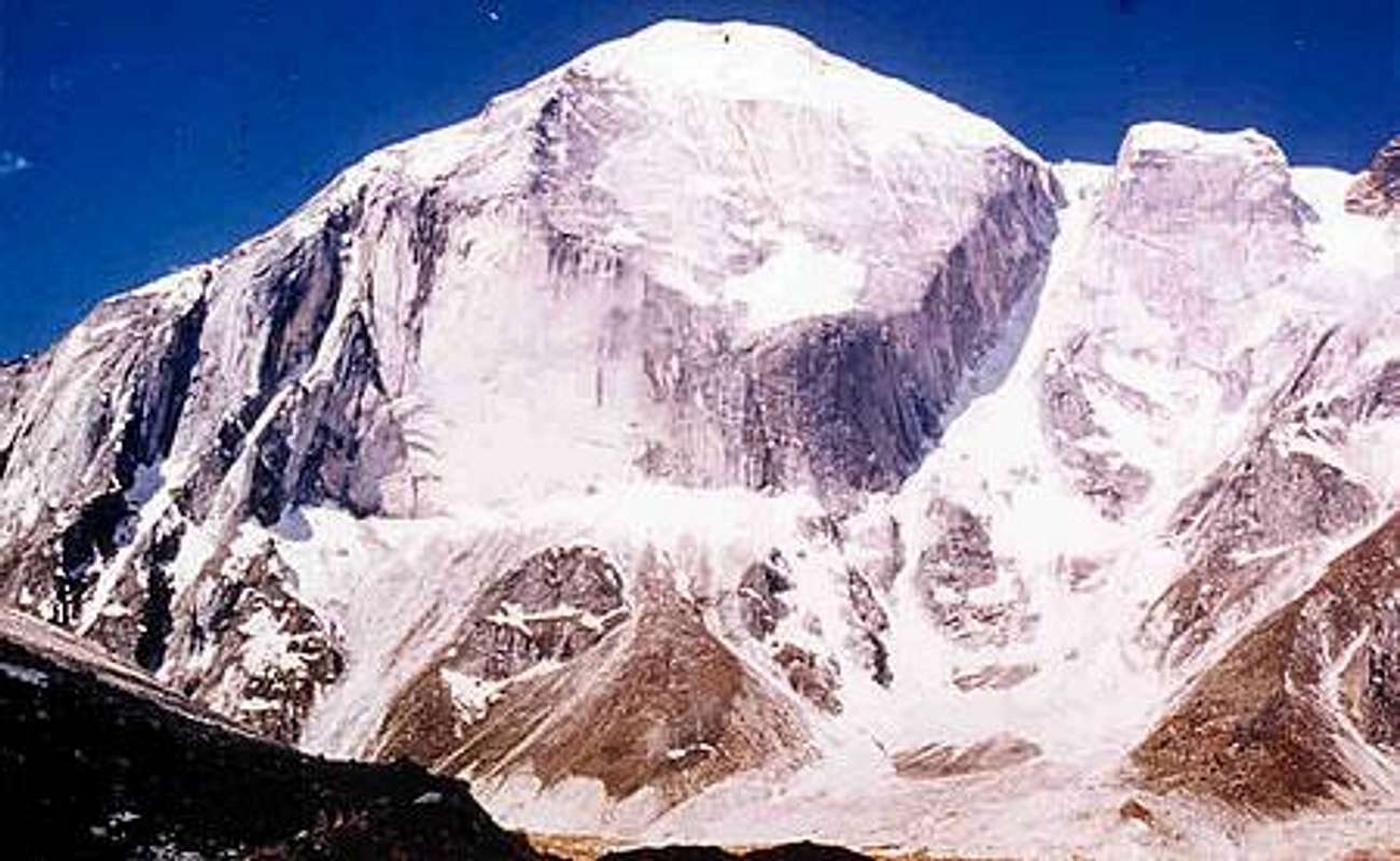
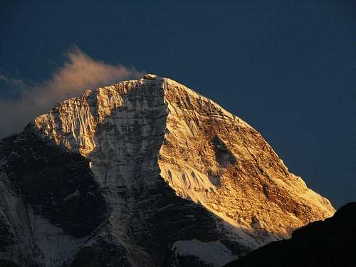
Photos of Peaks in the Region
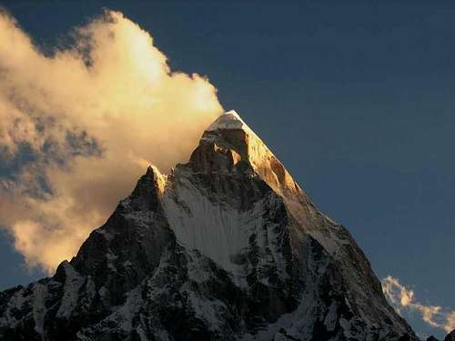
Morning rays hit Mt. Shivling !
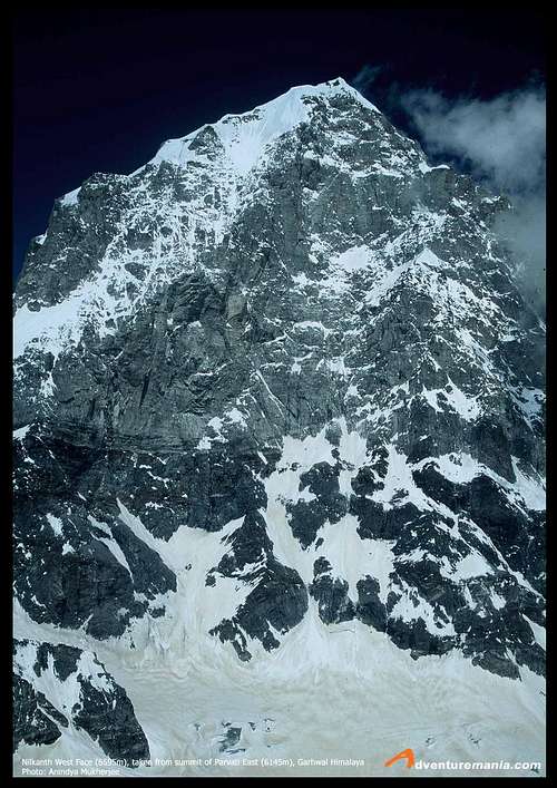
Mt. Neelkantha West Face, taken from Mt. Parvati East
Mt. Chaukhamba I
Mt. Kedar Dome
Mt. Meru I, II, III
Mt. Vasuki (Back) and Mt. Bhagirathi I, II, III
Mt. Sudarshan
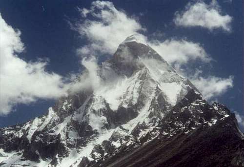
The Majestic Mt. Shivling
Mt. Saifi
Panoramic View - Mt. Shivling, Mt. Meru I, II, III, Mt. Thalay Sagar and Mt. Bhrigupanth
Mt. MandaII

Mt. Dunagiri
Mt. Manda
Eleutheros - Apr 1, 2008 12:12 pm - Hasn't voted
Wrong Height Listed In Article"The crowning glory of Garhwal is the beautiful Nanda Devi, whose twin summits tower over 26,600 ft above sea level." This would put Nanda Devi at over 8100 meters - Please correct this statement, as it is clearly false. Thanks!
lingana - Apr 9, 2008 10:55 am - Hasn't voted
Re: Wrong Height Listed In ArticleHi Eleutheros: Thanks for the correction. I made the correction in the article. The height is 25, 643 ft above sea level. Regards, S.