Mill B Trailhead to Lake Blanche
Hopefully this page helps someone not make the same mistake I did and helps them to avoid the very dangerous situation I was placed in on this beast of a mountain.
I was determined to get Dromedary after a failed attempt earlier this year. Despite getting stuck working later than expected Saturday, I parked my car at Mill B just after 2:30pm and headed up the "Lake Blanche Trail" to Lake Blanche. Running most of the way, I was able to make it to the lake in just over an hour. For reference, the hikers I hung out with at the lake said it took about two hours to hike there. This was the easy part. From here, Dromedary looks impossibly far away.
![Sundial and I from Lake Blanche on the way up to Dromedary]() After a tough hour to Lake Blanche
After a tough hour to Lake Blanche![Dromedary in the distance (top left) from Lake Blanche on the way up]() Dromedary (top left) in the distance from Lake Blanche---it does NOT look easy
Dromedary (top left) in the distance from Lake Blanche---it does NOT look easyLake Blanche to the Ridge
From here I simply followed the route directions I found here on SP and stayed to the North (right) of lakes Florence, and Lilian. There is a Dam at Lilian and it is here that you have to descend in to the drainage. I ended up walking up the stream on rocks for about 20 meters. From here I took the small bowl/chute to the right to get to the rock slabs on the left. I then took the rock slabs up until I came to the small hanging valley below the saddle (low point of the ridge). From here I crossed over to the right side of the valley and made my way up to the low point of the ridge. You have to be a bit careful on the slabs near the top but there is no exposure and it's not that bad.
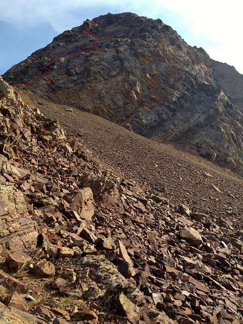
This image shows the best route that I could find:
![Route Up Dromedary From Lake Blanche]() Zoom in and follow the red line for the route up Dromedary from Lake Blanche
Zoom in and follow the red line for the route up Dromedary from Lake BlancheDon't do what I did!
Once I got to the ridge, I just scrambled my way to the base of the summit block. The scrambling was pretty straight forward and easy with little exposure---pretty quick. It was here I ditched my handheld Amphipod bottle knowing that I would probably need both hands and I was right! Once at the spot where the ridge starts to meet the steep summit block, I decided to go around the east flanks of the mountain to try the NE Face route. The route here on SP mentions this route as having a "faint hikers trail" and class 2-3 to the summit. I might also mention that going straight up from the ridge looked steep and intimidating. I slightly gained elevation while going around the East flanks and ended up on some rock slabs which looked reasonable and like they might be the trail. Unfortunately, I got cliffed out on the East flanks and never did find the hikers trail. I ended up rock climbing for 45+ minutes on places I had no business being alone and without ropes. I said many prayers and was just able to find a doable way each tight spot I got in to. By the time I reached the summit, my arms were tired out (this has never happened to me before on a mountain climb) and my adrenals were shot. I sat drained on the summit, shaking and tired.
Moral of the story: If you attempt the NE face route---find the hikers trail and do NOT try to make you way up starting on the rock slabs. My guess is that I either missed the hikers trail early or that I stayed too high while making my way too far around and that you will need to descend some elevation and stay low on the loose dirt and rock to make your way around to the Cottonwood ridge line if you want to go that way.
![Scarecrow on Sunrise?]() Sunrise from the Dromedary Summit---is there a scarecrow on top?
Sunrise from the Dromedary Summit---is there a scarecrow on top?The summit and a better route
Sitting on the summit, I ate, took in the views for a long time, and said a long and emotional prayer. At 6pm, I started down, knowing that I was going to have to book it if I was going to make it back before it got dark. I was determined to find one of the actual routes down found a faint trail no more than 15 feet from the summit that looked like it descended straight down to the ridge I had come up---the very route I had avoided on the way up. Although a bit steep, it was not very loose as I had heard it described and was pretty straight forward on the way down. There were several rock cairns for guidance---just keep an eye out. I made it from summit to my water bottle that I had left on the ridge in LESS THAN 15 MINUTES...MUCH better than the hour I spent on cliffs on the way up! This route wasn't that bad coming down. When I looked back up, it sure looked intimidating once again, but I knew that it wasn't that bad. It reminded me a bit of The Pfeifferhorn...it looks super intimidating but it's a lot easier than it looks.
![Another shot of the route]() Click and zoom to view the red line at my attempt at representing the easier route
Click and zoom to view the red line at my attempt at representing the easier route ![Zoom of Lakes Blanche (top), Florence, & Lilian from Dromedary Summit]() A zoom in on the lakes from the summit
A zoom in on the lakes from the summitBlazing the rest of the way down
It took me another 45 minutes of mostly scrambling to get from the ridge back to Lake Blanche, I basically followed the same route I took on the way up and didn't find a whole lot of better lines. I took some quick pics at the Lake and started down. It was at this point I got a runners high and was able to blast down from Lake Blanche to my car in 30 minutes.
![Lake Florence & Sundial on the descent from Dromedary]() Lake Florence on the way back
Lake Florence on the way back ![Sundial Peak from Lake Blanche on the way up to Mount Dromedary]() Lake Blanche before racing down the mountain to beat the sunset
Lake Blanche before racing down the mountain to beat the sunset


Comments
Post a Comment