
|
|
Area/Range |
|---|---|
|
|
22.33182°S / 68.00717°W |
|
|
Hiking, Mountaineering |
|
|
Spring, Summer, Fall, Winter |
|
|
14009 ft / 4270 m |
|
|
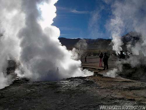
 Warming cocoa inside a geyser!
El Tatio is a geyser field located within the Andes Mountains of northern Chile at 4.270 meters above sea level (14.009 feet). Contrary to some reports, it is not the highest-elevation geyser field in the world. Puchuldiza Geyser Field, Chile, and possibly several other fields are higher in elevation (I did myself a higher area for geysers here at summitpost, in fact, way higher! This is the Geysers Sol de La Mañana, at 4.905 meters above sea level (16.092 feet).
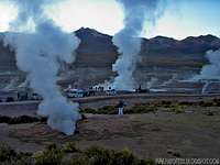
Tourists often visit the geysers while touring the nearby Atacama Desert and San Pedro de Atacama. "With over 80 active geysers, El Tatio is the largest geyser field in the southern hemisphere and the third largest field in the world, after Yellowstone, USA, and Dolina Giezerov (partially destroyed June 2007), Russia".
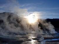
"Though possessing numerous geysers, none erupt very high. The highest eruption observed has been around six meters in height. The average geyser eruption height at El Tatio is about 75 centimeters". The best time to see them is at sunrise when each geyser is surmounted by a column of steam that condenses in the bitterly cold morning air. The steam plumes disappear as the air warms up. It is also possible to bathe in the hot geyser water in a small pool. However parts of the field are very dangerous with a thin crust over almost boiling mud so ask your guide where you may go.
There is wreckage at the site from an old project for harnessing geothermal power. The idea has recently been revived by the Chilean government and is meeting with heavy public resistance due to the touristic value the geyser field represents.
Curiosity: In mid-September 2009, a 200-foot permanent steam column was noticed. Further developments point to damage done by prospection by GDN, a geothermal exploitation company jointly owned by Chilean State holdings and an Italian Energy consortium.
Global Volcanism Program
Here's the update of GVP about El Tatio volcano and geysers:(source: http://www.volcano.si.edu/world/volcano.cfm?vnum=150508=A)
"A chain of dominantly Pliocene-to-Pleistocene volcanoes including Cerro Deslinde, Cerro Volcán, Cerros del Tatio, and Volcán Tatio is flanked on the west by a depression that contains some of the most dramatic thermal features of the Andes. Although no Holocene eruptions are known from El Tatio itself, it was included in the Catalog of Active Volcanoes of the World (Casertano, 1963) based on this geothermal activity. The 30 sq km Hoyada de Los Geisers del Tatio geothermal field contains 85 fumaroles and solfataras, 62 hot springs, 40 geysers, 5 mud volcanoes, and extensive sinter terraces. Geothermal energy exploration has been conducted, but remoteness of the location has precluded development.
Country: Chile
Subregion Name: Northern Chile
Volcano Number: 150508=A
Volcano Type: Hydrothermal field
Volcano Status: Pleistocene-Geysers
Last Known Eruption: Pleistocene"
Getting There/ Hints/ What to do up there
It is safer if you don't try to go to El Tatio geysers by yourself, the tour that leaves San Pedro de Atacama is really cheap, around US$ 50.00, and includes transport, guide, and on the way back a visit on Machuca village with Llama bbcue!
In spite of its proximity to the equator, the air can be cold, especially before sunrise. Depending on the month, early morning temperatures range from 4°C to -10°C. Bring hats, gloves and sweaters or jackets that can be peeled off as the air warms.
If you want to you can of course jump into a natural jacuzzi with water at 35°C, I didn't but hey, that's just me...
:^)
You can do several things in El Tatio...
>Simple tour with family and friends;
>Hot bath at the jacuzzis;
>Hike along the complex;
>Ascend El Tatio volcano (5.100m);
>Practice photography and night photography;
>Astronomical observations
Camping
Camping is forbidden in El Tatio, after all remember this is a volcano and it can erupt out of the blue. There is constant watch by GVP (Global volcanism Program) but you never know... No camping! Do what you have to do and get the hell out! :)
How and Why are Geysers Formed?
Source: Mr Wikipedia Amazing colours!
Geysers are formed as a form of outlet for the pressure build-up underneath the Earth’s crust, we should also make it clear that geysers do not just erupt at will or at random places. The steam pressure has to reach groundwater level and get trapped between the ground surface and the Earth’s layers. However, there are fissures or narrow shafts existing in between the Earth’s layers and they will serve like exhaust systems for the hot steam pressures. Meanwhile, the water reservoir underneath the groundwater surface and layers of land will reach its boiling hot stage as it comes in contact with the hot rocks. The heat and steam pressure created will escape through the fissures until it reaches the groundwater level.
As the heat reaches groundwater, the latter will also boil creating more heat and steam pressure but is already trapped just below the Earth’s crust. Due to this, pressures of great magnitude build up, and can only find release once the amount of pressure is enough to create ground eruption. Once eruption takes place, the trapped steam pressure will spew several thousands of gallons of boiling hot water, thrusting it many hundreds of feet above the ground.
Thus, a geyser has formed and soon after, regular eruptions of steaming and boiling hot water will be released. This is a natural occurrence in order to lessen the steam pressure that builds up near the Earth’s core, since there are hot rocks or magma that keep the water reservoir boiling. Geyser eruptions can be quite a spectacle. In fact, the “Old Faithful Geyser” has become a regular attraction at Yellowstone National Park. Most of those who visit the national park go out of their way just to see “Old Faithful” spew out gigantic fountains of steaming hot water, mud or even lava flow.
Certain facts on geysers are basic, but still important to know. There are approximately 1,000 geysers throughout the world and they are considered extremely rare features. Most of the world's geysers are located in Yellowstone National Park. The geysers in Yellowstone National Park were created long ago by volcanic eruption. The name “geyser” originated in Iceland and in Icelandic it means “to gush or rush forth”. The first geyser was discovered in Iceland in 1294 and called “The Great Geysir”.
Many geysers erupt straight up into the air. However, some geysers, referred to as Ledge geysers, erupt out of a hillside at an angle. Many geysers erupt due to the boiling of water. However, some geysers are powered by gas pressure and erupt from warm or cold springs. Some geysers erupt at regular intervals and others only erupt on rare occasions. Only six of the geysers located in Yellowstone National Park erupt regularly and their eruptions are predicted by the park's rangers. These six geysers include Old Faithful, Great Fountain, Riverside, Castle, Daisy, and Grand.
All hydrothermal features are called geysers once they erupt. Once a geyser has been named a geyser, it is always called a geyser even if they no longer erupt. Other hydrothermal features include mud pots, hot springs, and fumaroles. There is one significant difference between hot springs and geysers: steam and water cannot flow through the cracks in a geyser's rock because these cracks are too narrow.
Legal Issues
To hike/ climb is a dangerous activity and requires proper equipment and clothing, the owner of this page cannot be blamed by injuries caused to anyone who read this page for its info about the mountain, and eventually got hurt by doing so with reckless behaviour or bad weather conditions.
Paulo Roberto Felipe Schmidt – AKA: PAROFES
External Links
A brazilian website to get mountains info, including gps files to download:http://www.rumos.net.br/rumos/My youtube channel: www.youtube.com/parofes - Now with 250+ videos online!
The biggest brazilian website about climbing and mountaineering, for which I'm a columnist: