
|
|
Canyon |
|---|---|
|
|
36.93600°N / 111.483°W |
|
|
Aid Climbing, Big Wall, Mixed, Scrambling, Via Ferrata, Canyoneering |
|
|
Spring, Summer, Fall, Winter |
|
|
Overview
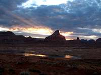
Glen Canyon begins at the confluence of the Dirty Devil and Colorado Rivers near Hite, Utah. It extends southward to Lees Ferry in Arizona where the Colorado River flows through Marble Canyon and on toward the Grand Canyon. Glen Canyon National Recreation Area encompasses this area. It is managed by the National Park Service and stretches over 1.2 million acres. To the west are Grand Staircase-Escalante National Monument and Capitol Reef National Park. To the east and north are the Navajo Reservation, the BLM land of Cedar Mesa and Dark Canyon, and Canyonlands National Park. The Recreation Area is anchored by the Glen Canyon Dam which was started in 1956 and finished in 1963 but it took many years for the Colorado, San Juan, Escalante, and Dirty Devil Rivers and their tributaries to fill Lake Powell behind it. In 1980 the lake was considered to be at full capacity, but in recent years drought has made it so the level of Lake Powell has dropped making some areas that were once under water accessible for hikers and canyoneers once again. Some believe that Lake Powell should be permanently drained and the area restored.Lake Powell was named after Major John Wesley Powell, the first white man to explore its length. He went on to explore the Grand Canyon as well. I highly recommend reading his book, The Exploration of the Colorado River and its Canyons. In it he named Glen Canyon. He described, "...wonderful features -- carved walls, royal arches, glens, alcove gulches, mounds and monuments. From which of these features shall we select a name? We decide to call it Glen Canyon."
One can spend a lifetime exploring this vast and beautiful area. The scenery here is incredible and some believe it should be a National Park. Some highlights include:
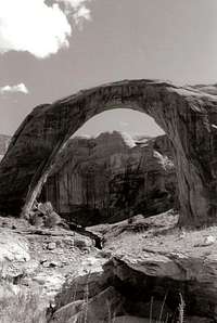
Rainbow Bridge National Monument
San Juan Arm/Grand Gulch
Escalante Canyon
Navajo Canyon
Burr Trail
Lee's Ferry
Orange Cliffs
Getting There

By car:
US Hwy 89 and 98 skirt the canyon/lake to the south. Page, Arizona is a town right near the Dam where these two highways meet. Hwy 276 crosses the canyon/lake right at about its half-way point at Bullfrog Marina. Well, cross isn't a literal term, as you must take a ferry to get across here. Hwy 95 crosses the canyon/lake at its northern end at Hite Marina. These are the main paved roads that you can use to access the area but there are some dirt ones including the Hole in the Rock Road and the Red Canyon Road. Since this is such a huge area, and much of it very remote, it is highly recommended you purchase a good map of the area!
Online Maps
Trails Illustrated Map for Glen Canyon
Recommended Book: Hiking Grand Staircase-Escalante & the Glen Canyon Region by Ron Adkison
By boat:
Much of Lake Powell is only accessible by boat as it has about 2,000 miles of shoreline, more than the entire west coast of the U.S.! You can take a tour, bring your own boat, or rent a variety of boats from kayaks and personal watercraft all the way up to a houseboat. Boat rentals are at Wahweap and Bull Frog Marinas (see contact info below in the camping section.) Newly opened is the Antelope Point Marina on the Navajo Reservation and it offers boat rentals, a floating restaurant, general store, and soon to come, a hotel and RV park.
Red Tape

There is a $15 fee charged for entrance into Glen Canyon National Recreation Area. This fee will get you a pass good for 7-days. You can also buy a $80 America the Beautiful Federal Lands Recreation Pass good for entrance to all National Parks, National Forests, BLM, US Fish & Wildlife, and Bureau of Reclamation sites for one year from date of purchase. If you're disabled, you may want to get an Access Pass which are free and good for a lifetime. If you're 62 years of age or older, a Senior Pass can be purchased for $10 and they're also good for a lifetime. Click here for more info on fees and passes.
Camping
Campgrounds Operated by the Park Service
Lees Ferry Campground
$10 per night / per site
55 developed sites - no hookups
Stanton Creek, Hite, Farley Canyon, and Dirty Devil
$6 per night / per vehicle
Primitive Camping
Lone Rock Beach
$8 per night / per vehicle
Beach Camping Area
Camping is limited to 14 consecutive days, 30 days maximum per season. No camping is permitted at Rainbow Bridge National Monument.
Campgrounds operated by the Park's Concessionaire
Wahweap
112 dry campsites (no hook-ups), 90 full hook-ups, and 6 group camping sites. Facilities include restrooms, laundry, showers, store, phones, dump station and potable water. The amphitheater, picnic area and swim beach are nearby. To make reservations for full hook-ups call 800-528-6154. To make reservations for group camping, call 928-645-1059. Reservations are not taken for dry campsites. Fees vary.
Bullfrog & Halls Crossing
Bullfrog: 78 sites, restroom, phones, dump station, potable water station, ½ mile to laundry, store and post office and launch ramp. No reservations. Fees apply. The concessioner also operates a seperate RV park. 24 sites, full hookups, restrooms, and showers. ½ mile to laundry, store, post office. No launch ramp. For reservations call 800-528-6154. Fees apply.
Halls Crossing: 63 sites, 2 group sites, dump station, potable water, cold shower. Laundry , store, gas, phone, ½ mile. The concessioner also operates an RV park with 32 full hook-up sites. ½ mile to store, laundry, and showers. For reservations call 800-528-6154. Fees apply.
Weather and Safety

National Weather Service Local Forecasts
A complete list of good safety information can be found here. Here are some of the finer points...
Obtain Maps & Current Information
Hiking here is generally on unmarked routes. Obtain current hiking information and topographic maps prior to your trip. When possible, stay on established routes. Let someone at home know your plans and when you expect to be back.
Know Who to Contact in an Emergency
Keep in mind that cell phones do not work in many parts of the canyon, so don’t count on them. Bring a signal mirror as a backup communication device.
Drink Plenty of Water
Drink a minimum of 1 gallon of water per person per day. Filter or treat all water.
Know Where You Are
Hiking in Glen Canyon and its tributaries often requires walking in water and beating a path through thick vegetation. Side canyons are easily missed. Stay oriented to your location by using a topographic map.
Beware of Hypothermia
Many canyons have deep pools that require wading or swimming. Wet conditions may cause hypothermia even during hot weather. Carry dry clothing.
Quicksand is common here
Although few pockets are more than waist-deep (most are less than knee-deep), it’s best to avoid it. If you do step in quicksand, don’t panic!
Be Prepared for Poor Road Conditions
Storms can leave dirt roads impassable for several days. Leave extra food and water in your vehicle.
Flash Floods
Flash floods can occur at any time of year, but they are most common in July, August, and September. Checking the local weather forecast is advisable, but you should realize that conditions change quickly, and it is impossible to predict where heavy rain will occur. Avoid narrow canyons and washes during stormy weather. Be aware of changing weather conditions. Know your escape routes. If you’re hiking in a stream, be aware of rising water levels or stronger currents and sudden changes in water clarity. Educate yourself on the terrain you are entering. Realize that dry washes are a result of previous flash floods.
By entering a narrow canyon or wash, you are assuming a risk.
If flooding begins, seek high ground and wait for the water to go down before attempting to walk out. Do not enter a narrow canyon if storms threaten. Never camp in a wash bottom.
Creepy Crawlies and Other Things
Educating yourself about the hazards associated with snakes, insects, and poisonous plants in the desert is essential.
Deer flies and gnats come out in the early summer months. In wet areas, wear long pants and long sleeve shirts to avoid fly bites.
Poison ivy grows here near water sources. Know how to identify it — remember, “leaves of three, let it be.”
External Links
Glen Canyon National Recreation Area
Rainbow Bridge National Monument
More info on the Glen Canyon Dam
More info on John Wesley Powell
The Glen Canyon Institute
For more information, please contact

Glen Canyon NRA
PO Box 1507
Page, Arizona 86040
(928) 608-6200
Visitor Centers
Glen Canyon National Recreation Area Headquarters, Page, AZ, Monday - Friday, 7 a.m. to 4 p.m., closed 12 noon to 1 p.m.; closed Thanksgiving, Christmas, and New Year's Day.
Carl Hayden Visitor Center, Page, AZ, daily, Memorial Day - Labor Day, 8 a.m. to 6 p.m.; rest of year, daily, 8 a.m. to 5 p.m.; closed Thanksgiving, Christmas, and New Years.
Bullfrog Visitor Center, Bullfrog, UT, intermittently in April, daily May - Labor Day, 8 a.m. to 5 p.m.; closed mid September - March.
Navajo Bridge Interpretive Center, near Lees Ferry, daily mid-April - October, 9 a.m. to 5 p.m.; weekends only, early April and November, 10 a.m. to 4 p.m.