
-
 13554 Hits
-
 80.49% Score
-
 12 Votes
|
|
Route |
|---|---|
|
|
46.47931°N / 10.56696°E |
|
|
Mountaineering |
|
|
Summer |
|
|
Most of a day |
|
|
AD |
|
|
Overview
Gran Zebrù/Königsspitze Normal route
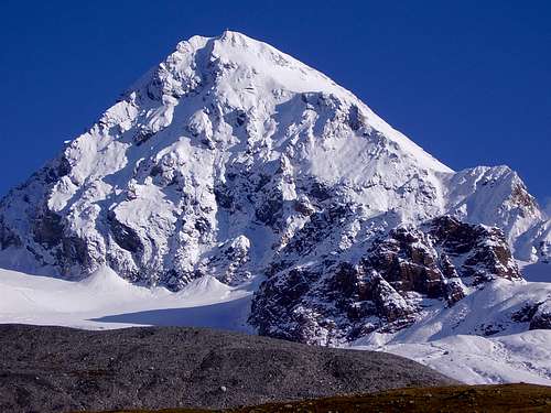
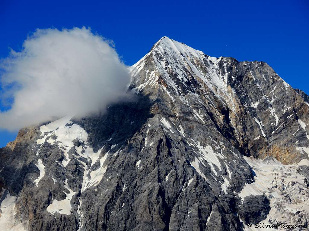
Gran Zebrù 3857 m - the original name is Königsspitze - is a mighty mountain belonging to the Ortles-Cevedale group and it is the second highest peak of the massif, after the Ortles (3905 m). Wherever you look at it, Gran Zebrù is one of the finest mountains in the group, if not the finest. In South Tyrol and in German literature it is known by the name Königsspitze, whose meaning is "summit of the king".
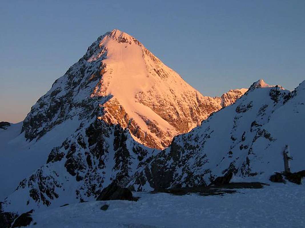
Gran Zebrù is surely one of the finest peaks in the Alps. Summiting it even on the standard route is often delicate and requires experience.
History
The history of mountaineering assigns the first ascent of Gran Zebrù to the teamvcomposed of the British Francis Fox Tuckett and the Buxton brothers accompanied by the Tyrolean guides Biener and Michel who completed it in 1864. The pioneers followed the route through the shoulder and the SE ridge, that of the current Via Normale.
The possibility that the summit was soloed by the Bavarian seminarian Stephan Steiberger ten years before Tuckett is still shrouded in a halo of mystery. (See La Rivista del Cai, Sept-Oct 2004).
Getting there
The starting point to climb the Normal route is the Rifugio Pizzini in Val Cedèc. The closest village is Santa Caterina Valfurva m. 1734, situated 12,5 km. to Bormio, an important destination. From here you need to drive to the Rifugio Albergo dei Forni, where there is a wide parking area. Santa Caterina can be approached from Milano following the Valtellina or from Alto-Adige through the Stelvio pass.
- From Autobrennero exit Bolzano and follow the road to Merano, then enter the Venosta Valley and follow it to the fork in Spondigna. Turn to left, following the road to Passo Stelvio (2758 meters, open only in the summer period). From here descent to Bormio (3 hours and half from Bozen, Stelvio pass requires 44 bends to go up and 15 to go down).
- From Milano follow the state road "Valsassina" n. 36 to Lecco and then to Colico, here take the "Valtellina" road to Morbegno, Sondrio, Tirano and then to Bormio.
Road to Rifugio-Albergo Forni
From Santa Caterina Valfurva take the steep road which after about 8 km reaches the large parking area located near the Rifugio Forni 2178 m. There are some rules about the private traffic on this road:
- pay a toll in La Fonte car park in S. Caterina Valfurva -Via Forni at the info-point with automatic ticket-machine.
- Snow tires and chains on board are mandatory until 30.05.2019
Approach to Rifugio Pizzini
From the parking area near Refuge Forni 2178 m take the unsurfaced road which after a few bends enters the Val Cedec. A simple itinerary along the hillside leads to the Capanna Pizzini shelter in about 1 and a half hour.
Route Description
Gran Zebrù Normal route from Rifugio Pizzini
Difficulty: Alpine AD-
Starting point: Rifugio Pizzini-Frattola m. 2700
Exposure: South
Despite being the Normal route to the top, this route should not be underestimated. It is a steep slope that must be in good condition to be climbed and that in recent years is increasingly bare of snow and therefore often "in ice". For this reason it is advisable to climb at the beginning of the season, when the route is in good snow conditions.
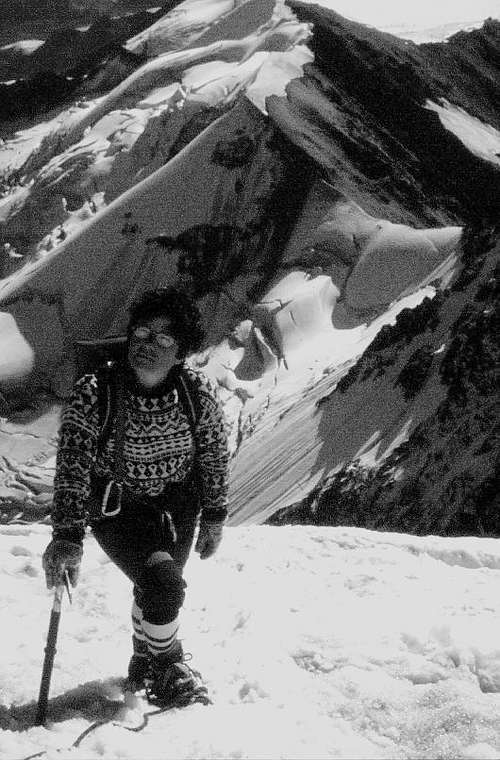
The South face of the Gran Zebrù is clearly visible from the hut and with it almost all the line of its Normal route. From the refuge take the trail heading straight in the direction of Gran Zebrù (NNW). The trail, indicated by different cairns, in its first stretch goes up the stones and gravels of the moraine heading to the left of the huge and obvious reddish rock pillar under the Gran Zebrù, where the tongue of the glacier ends, half-buried by the debris, just below the red rock wall. You reach the end of the trail, at the start of the glacier, in about 1 hour, 3150 m. Start to walk on the "Vedretta del Gran Zebru" glacier (crampons on), surrounding the red rock, staying wide to avoid the crevasses, then turning behind to the left, keeping under the Gran Zebrù wall. At a certain point it is obvious at the top a narrow gully less than 200 meters high, long, coming from the shoulder on the East side of the mountain. It's the "Collo di Bottiglia" - "Bottle Neck"- , which must be climbed to its end to reach a saddle situated under the shoulder going up to the summit. The gully can be slightly snowy and with sections of stones in late season and is at risk of falling rocks. Approach the bottom of this large "X shaped" and start to climb it (3200 m), reaching the shoulder 3500 m (steepness upt o 45-50 deg. max., 45 min. dir N). From the saddle at about 3550 m start to climb the steep shoulder directly towards the summit (cross clearly visible a little on the left). Climb on the side of the rocks at your left (dir NW) to an open snow/ice field with less stepness. Cross climbing to N to the North side of the field, looking for a small colouir leading to the final ridge (3800 m steepness upt o 45-50 deg. max.).
Follow the ridge (dir W), paying attention to the snow-frame towards the North with a breathtaking view towards the Ortles. A few meters along the ridge and the summit is reached (metal cross and summit book).
Descent: reversing the route
Few rules:
1) Do climb it early, the mountains face catch the first sun, and the snow will soft soon
2) Descend early for the same reason
3) Consider carefully the presence of other teams above you and act in a way to avoid to be involved in a not nice "group slide"
Essential Gear
This may be a very serious climb (up to AD) depending on ice conditions, consider the use of:
1) difficult glacier equipment
2) helmet
3) some ice screws
Red Tape
No fees no permits required. Gran Zebrù and the whole Ortles-Cevedale Group are situated inside Parco Nazionale dello Stelvio, one of the hystorical national parks in Italy, belonging to the provinces of Trento, Bolzano and Sondrio. Free camping is not allowed and fires are strictly forbidden. The whole fauna and flora are protected.
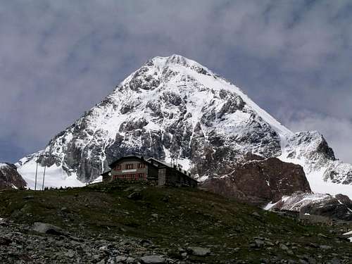
Hut
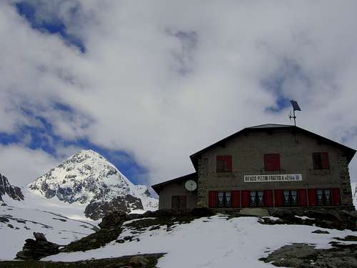
- Rifugio Pizzini-Frattola m. 2700
The Refuge Pizzini-Frattola is located in the large basin at the head of Val Cedèc in a majestic amphitheater, closed by Gran Zebrù to the North and Cevedale to the East. Owned by Club Alpino Italiano Sez. Milano, it was built in 1887 and destroyed during the First World War.
Climbing attitude
1) be ready to face a steep descent often needing a good crampons technique and/or a sticky snow
2) be careful going "ensamble", and be ready to perform some length with a fixed safety points
3) consider the weather, it's difficult to get lost, it's easy to have strong wind when you need to be well balanced, lightning may be very dangerous
When to climb
Meteo
Meteo ARPA Lombardia
Meteo Provincia Bolzano
Guidebooks and maps

“Ortles Cevedale – Parco nazionale dello Stelvio” by Gino Buscaini – Collana Guide dei Monti d'Italia CAI-TCI (Club Alpino Italiano-Touring Club Italiano)
Map “Ortles-Cevedale” sheet 72 - Kompass 1:50.000
seano - Aug 7, 2018 5:41 am - Hasn't voted
Route has changedThis may only be an early-season route nowadays. I climbed it on 2018-08-07, and the couloir was all bare scree and rotten rock. Above, the east-face glacier was bare ice, and most people seem to climb the rotten rock to its left, where there are several fixed lines. The rock quality is uniformly terrible, with lots of loose stuff that you cannot help but kick down. I would not recommend this route.