
-
 566 Hits
-
 78.27% Score
-
 9 Votes
|
|
Route |
|---|---|
|
|
46.54639°N / 86.70931°W |
|
|
Hiking |
|
|
Most of a day |
|
|
Overview
Lake Superior’s Grand Island, just off the coast of Michigan’s Upper Peninsula, was never something on my radar as a wilderness destination. While quite large (50 square miles), I think in my ignorance I assumed it was domesticated long ago due to it being just a short ferry ride away from the town Munising, the western gateway to the beautiful and rugged Pictured Rocks National Lakeshore.
I could not have been more wrong.
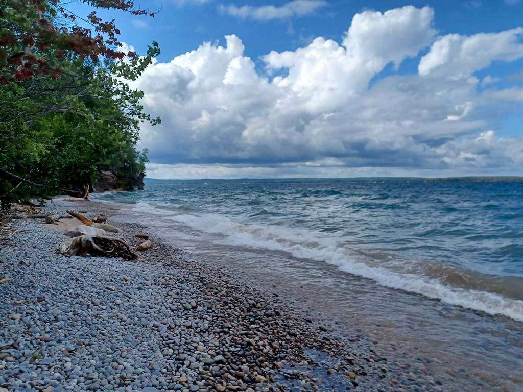
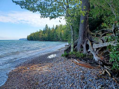
I half-heartedly threw in a trip to Grand Island on a long weekend to the area, mostly to get a bike ride in on my first day, since I would not arrive in the area until mid-morning. I expected a pleasant bicycle ride in a Northwoods resort type environment. WRONG. The short ferry ride takes you to a vast rolling, forested bulwark against powerful Lake Superior, the fresh water inland sea between Canada and the US that is the size of Austria. Grand Island has 35 miles of nearly pristine shoreline and 50 miles of bike and foot trails.
Getting There
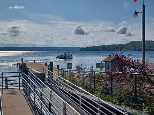
The ferry to Grand Island is just west of the town of Munising, Michigan, in that state’s Upper Peninsula (or UP aka Michigan’s better half). Munising is 170 miles NE of Green Bay. Note Munising is on eastern time and that the last ferry back from Grand Island is 6 PM.
Route Description
The most scenic areas are on the north side of the island, furthest way from the ferry landing. So to do justice to the island I would have to either camp at least a night, or bring a bike since they are allowed on most trails. The 20 mile loop around the island I planned (a distance which usually takes me less than two hours) took me a tough 5 hours (with photo stops and breaks) and exceeded all my expectations.
The trails ranged from crushed limestone roads to old double track devolving into single track…with sand, mud, dirt, roots and brush sprinkled throughout. The ride got quite rugged in the north of the island, and several places I had to walk my bike up a steep or loose uphill section.
After a brief ferry ride with a knowledgeable pilot (‘Do not put you backpack down anywhere– bears are all over the island and they love raiding food’). I did the loop around the shoreline paths clockwise, a route that took me immediately into the forest along some crushed rock roads. However aside from a tour bus and a ranger truck that roam the southern part of the island there are no cars allowed.
While the trail system had numerous, detailed signs, without a map on hand one cannot always understand what the signs are pointing toward. Please have a good map with you.
I took the road north from the ferry landing on the West Road and went left whenever a sign indicated something to see. And there was plenty.
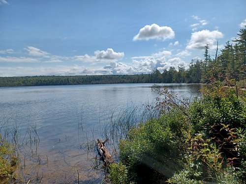
As I moved north I took the option to cut over east to see Echo Lake, possibly the world’s oldest (1800 years) and largest beaver made lake.
But I returned to the west road and continued north along the coast.
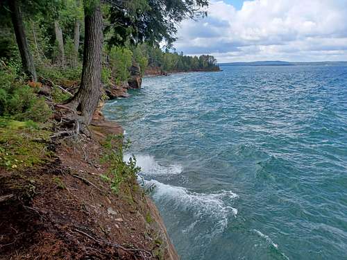
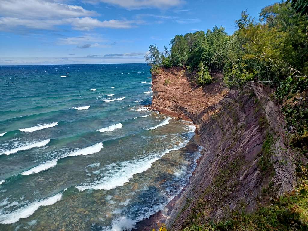
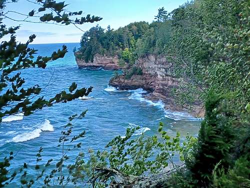
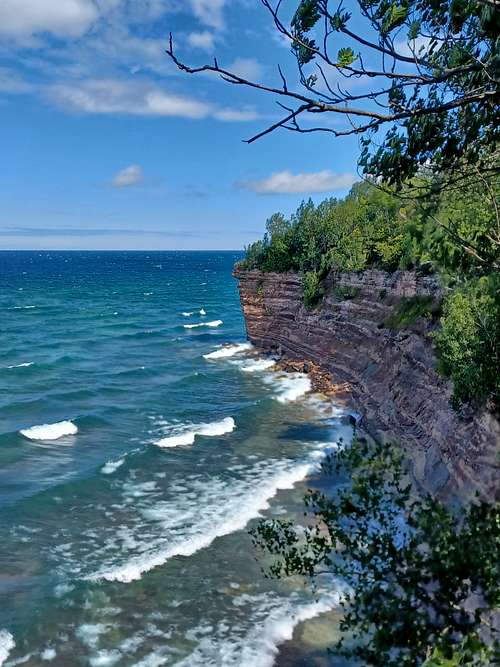
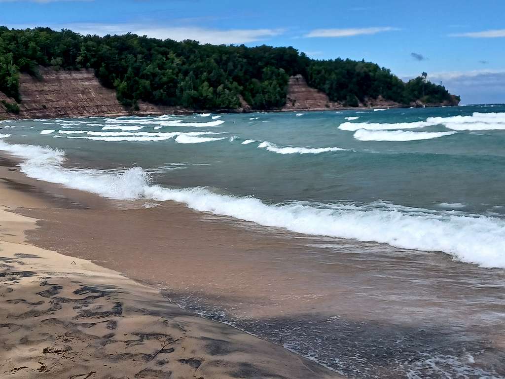
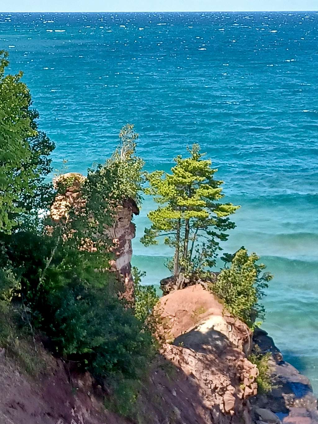
The trail was its most rugged after mile 5. Long broken rocky trails both up and down hill – but mostly up. But after a few miles of rough going and walking the bike uphill, the northern edge of Grand Island was reached. The cliffs on this side of the island absorb the most punishment from Lake Superior, and the first view point was grand.
With still most of the North cliffs of the island to see, I had only traveled eight miles.
Again, take the time to explore side trails and viewpoints. You will not be disappointed. Viewpoint after viewpoint was a delight on a mostly sunny day, with a stiff wind that produced big waves and reduced bug waves. I could not have asked for a better introduction to Grand Island.
After enjoying the many cliff views, I eventually sped precipitously down the bumpy trail to North Beach, and its long stretch of sand.
Afterward the west road becomes the east road and you start heading south, mostly encased in trees for long stretches and only occasionally breaking into places for larger views. But those few views are beautiful.
The last part of the loop goes faster as you are now on the network of crushed rock roads that serve the tour bus. Taking a mapped short cut on a single track, I saved 0.4 miles but barely survived the descent to the south shore. I sped past many of the historical buildings on the south part of the island in my haste to get back to the ferry at the top of the hour, plus a small group of houses grandfathered in when the island was donated to the Forest Service.
I know anyone on Summitpost would enjoy the views and the day I had. But afterwards I learned how much on the island I missed in my ride along the island edges. There are caves, old growth trees, shipwrecks and remnants of Grand Island's past history. I had smugly cruised by a few backpackers on the trail but now realize that they were probably seeing much more of the island than I.
I will be back to see some of the many sites I missed – and, of course, there is still a highpoint somewhere on the island to find.
Red Tape/Safety
The Grand Island National Recreation Area is part of Hiawatha National forest.
Ferry changes in 2023 were as follows:
Adult: $23 Child (ages 6 to 12): $15 Child (ages 0 to 5): Free
Bike Transportation: $10
The National Forest charges $5 per person per day (1 day included in ferry fee).
Safety - Please read!
Cliffs All over
Hypothermia (Lake Superior rarely gets above 45 degrees F) - Swim at you own risk.
Rip Tides - See above
Bears From Forest Service: Bear encounters on Grand Island have become increasingly frequent and are ongoing, especially in campsites around the island. Law enforcement and recreation staff have responded to multiple reports of bears taking both food and other human-scented personal items, such as backpacks and shoes. Some personal items did not contain food and were properly packed according to backcountry guidelines. This means that the bears are associating any human scent with food rewards.
External Links
Great Book, in depth on all the island's treasures, with detaied maps.
Exploring Grand Island by Michael Neiger