
|
|
Area/Range |
|---|---|
|
|
39.06895°N / 108.09019°W |
|
|
Winter |
|
|
Skiing Mesa Creek Backcountry Ski Area
I’d like to expose a rarely covered topic in our desert hamlet, self propelled snow travel. I use the word skiing in a loose sense as I enjoy snowboarding, downhill skiing, free heel skiing, cross country skiing, and alike. All have their merits and social distractions but I just enjoy sliding on my feet and bounding down hills with passable style any way I can. I think it is in my nature to slide on snow as I am half Swedish, a little Norwegian, German, along with various smatterings of here say genetics that I brag about but can’t really confirm, like Cherokee from both sides of my lineage (did you catch that rambling?)Gettting There

To access these old mythical runs, one must don climbing skins or snow shoes (or flounder in the powder up to your head) and start up the sledding hill just below the steeper upper section. Make a right in to the trees and cross teh sloping rickety bridge to the bottom of the old runs. Follow the most prominent track that usually goes to the right then left of the main run. This run was called Pruess from 1942 to 1966. Pruess is an excellent wide open, rolling and is sublimely angled. Sometimes it amasses enough snow for cautious skiing as early as mid October!
Winter is the ONLY Season
 Top of Pruess
Mesa Creek Runs
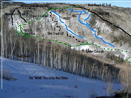
Further up the catwalk is the top of the original rope tow line. This is the steepest, narrowest, and potentially exciting run on the mountain. It requires good coverage to fill in the deadfall and boulders that litter the line. If more than three tracks are laid it is best to wait for the next dump to avoid the frustration of crossing deep ruts with little chance of escape into the thick forest lining this steep slot.
There are several glade runs just to the looker’s right of the “Tow Line.” All of these tree runs come out on the road below the parking lot and take a short hike or a thumb ride back to the car.
West Bench Access
 The rickety bridge.
One of the more infamous runs on the broad bench stretching across to the slopes of Powderhorn Resort is the rarely filled in “South America” boulder field. It is easily recognizable by its shape, but not easy to find.
Brother Dirk and I went in search of this run. From the top of the “Tow Line” we headed farther up the cat trial and above left through a broad meadow to the West Bench trail. From here we headed west out the trail to barely noticeable drainage crossing the trail about and open field below the trail. We mistakenly stayed high and right of the drainage and instead found ourselves just to the skiers right of on our own run we called “Southern America” due to the relatively flat “Griddle” boulder field and down the brambles below to the road. It was fun, but not in the classic skiing sense of the word.
Mudslide Runs
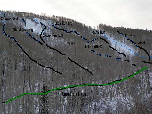 Mudslide Runs
The next run over I call the “Square” starts in the middle of the first parking lot with a narrow start through short aspens into a short “Square” field with nice drops, then into tight trees and out to a low angle bush whacking fiasco to the sled hill parking lot.
At the corner of the 1st parking lot starts a sweet funnel into the right side of the “Shack Run.” This run stays in the funnel to a steep face into a scraggly deadfall funnel out, again to the bushwhacking. The shack can also be started left on a broader slope and then back right into the funnel avoiding serious deadfall barring runs between this and the “Mane” run.
The next shot over is a fun start into a “Little Culvert” that must be cautiously cut out to the left above a log jam and into the trees that eventually allow exit to the lower Mane Run.
Ahhh “the Mane Run.” I refer to this local classic as a lion’s mane rather than its obvious, wide open and well traveled status. Access the Mane by parking in the second upper parking lot and walk back down the road till the trees give way to a broad slope. This run has the most open feel of any of the Mudslides and is tons of let-it-rip fun. Early season and in questionable conditions, it is best to stick to the shaded and tubular left side of the run and is typically exited left into the trees to the upper sled hill before the run flats out into bush and deadfall.
The next run up the hill is the “Culvert.” It is named for the 5-15” droppable drainage tube under the road. The culvert continues into a fun natural half pipe feature and snakes its way right back to the middle of the Mane run.
There is fun trees just left of the Culvert that must be exited left or right before skidding onto a huge log jam that rarely fills in.
The “Funnel” is up an obvious run in the middle of the second lot. It trends right into a choke. Be careful in most seasons not to get to out of hand as stumps and logs are sneaky in all the fun looking spots. This run also runs into log jam most of the season so must be traversed left to the fringe of a boulder field rarely in condition, then out the drainage to the upper sled hill.
At the upper corner of the second lot is access to a rarely in season set of runs. With optimal coverage traverse hard left into the boulder strewn drainage. Follow this to several tubes and ridges. Stay to the far right and you can gain the top of the best boulder drops available. Trend left and a mix of trees and a hidden lines can be enjoyable but also lead to frustrating flats, especially for snowboarders with out a ski buddy to “pole” them out.
More Skiing Oportunities in the Area
 La Sal boarding.Mudslide Runs
Grand Valley-
Grand Mesa Nordic Council Cross Country Ski Areas
(On top of the Mesa, 50-60 minutes from Grand Junction.)
Water Dog, Lake of the Woods and Mesa Lakes trials- These lower areas provide great views and a less structured cross country ski setting.
Sky Way- XC Ski only, no dogs I recommend the Sunset Overlook and far views of the La Sal Mountains to the west in Utah.
County Line- Dogs welcome. I recommend the Scenic Overlook from the Elks to the San Juans.
Crag’s Crest- Early in the season the steep trail is rough but doable to the Crest for the best views on the Mesa. Later on Avalanches and filled in steep slopes make the upper trail difficult but the slopes just above the road make for great laps.
Ward Creek- I recommend the Scenic over look here and the mellow Staircase trail.
-La Sal Mountains, UT-
90 minutes from town via Cisco road to Castle Valley.
Geyser Pass Trailhead- offers great winter access to cross country and back country skiing fairly close to Grand Junction. It is in a much more dramatic and mountainous setting than the Mesa. Avalanche is as real a concern here for the higher mountains as much as anywhere on earth. Avoid the high peaks until spring or be very cautious choosing conditions and routes to climb and or ski.
-Sunlight Mountain XC Trails-
The cross country trails here feature gorgeous trees, a nice flow and nice people.
I have been told that Williams Peak features excellent terrain, good trees with great access.
-Colorado National Monument-
Yes, in good years the upper Liberty Cap trial is neat to ski all the way down to the cliffs above the cap itself. Someday I’d like to shuttle this and finish the ski with a hike to the bottom.
-Arches National Park-
I don’t know exactly where but with enough snow this is a very photogenic location for XC skiing!
-Glade Park-
Fruita Reservoirs, Enoch Lake- I haven’t done much XC Skiing up here but access is good and it is better than nothing.
If you know or have better names for the runs and especially if you know of other areas near us with good access, please fill me in!
Contact me at:
seth@lokiusa.com
 Moose and Bell above Crag Crest Trail in April.