
Comments
No comments posted yet.
|
|
Album |
|---|---|
|
|
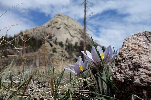
Hiking, Flora, Topo/Diagram, Informational, Scenery, Panorama |
Greyrock Trail is designated a National Recreational Trail. It was built in the 1930s by the Civilian Conservation Corp (CCC), and is very popular among local residents. On weekends the parking area often fills up. After crossing the footbridge across the Poudre River, the trail turns west and parallels the Poudre River for a short distance before turning north to being a gentle climb toward Greyrock Mountain. At about 1/2 mile the trail divides. The right branch turns uphill for 1.7 miles where it meets the upper end of the Meadows Trail. The left branch, which is the Meadows Trail, is slightly less strenuous but longer, and rejoins the main trail about 2.6 miles later. Both trails are rocky, with steep ascents and descents.
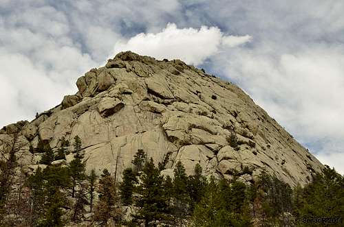
Turn right to continue up the Greyrock Mountain Trail. There are nice views of the Poudre Canyon, and a bench a short distance up from the trail fork, providing a comfortable place to rest and enjoy the views. The trail enters a small canyon, with frequent steep ascents as it climbs up through the canyon on its way to the Rock. Near the top of the canyon, the terrain begins to open up, and the trail makes a few switchbacks as it crosses a ridge. You'll come upon a rock outcropping offering terrific views of the canyon you've just ascended and the Poudre Canyon far below. This is a great resting place, but don't stay too long, the final destination is not far. A few more ups and downs, and you'll arrive at a meadow area at the base of the "rock" that gives Greyrock its name. The Greyrock Meadow Trail meets up with Greyrock Trail in this meadow. This meadow is a social gathering area, and a good place to rest, drink and eat before continuing your ascent to the summit. Note this this is NOT Greyrock Meadow. Greyrock Meadow is to to the west and down the hill about 1/2 mile.
From this junction, turn right (east) to scramble up Greyrock Mountain via the summit trail, which covers the final 3/4 mile climb to the summit. The trail winds around the back side of the rock, and the final ascent is not technical, although it is not for the faint of heart. There are several areas that require some hands over feet scrambling, but climbing equipment is not required. The trail is difficult to follow in areas, and if you go the wrong way, you may find yourself face-to-face with a steep rock face. the trail is marked along the way with wooden trail posts and cairns (rock piles). Pick your route carefully, and make sure you find the next cairn or signpost before proceeding.
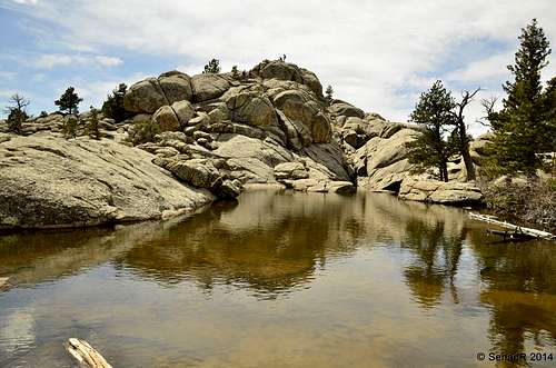
After climbing for about 1/2 mile, the terrain surprisingly opens up to a flat, forested area. Just beyond that, a short scramble brings you to the pond below the summit. Completely surrounded by rocks, it is a unique and special area. The final climb to the summit can be unnerving. There are steep dropoffs, especially along the south side of the rock. But with careful hand over foot climbing, you soon find yourself rewarded with incredible views of the plains to the east and northeast, and of the mountains from the south to the northwest.
Returning the way you fame down the summit trail, you'll arrive again at the meadows and the trail junction. From here you have two options: 1) Return the way you came, for a 6.2 mile round trip, or proceed west and return via the Greyrock Meadow Trail. Although the distance is slightly longer than returning down the Greyrock Trail, the Greyrock Meadow Trail offers a much different terrain, and terrific views on the way down.
After leaving the trail junction, you soon begin your descent into Greyrock Meadows. The burned trees surrounding the trail were victims of the Picnic Rock Fire that burned through the area in April 2004, scorching much of the area to the east and northest of here, as well as parts of Hewlett Gulch. Soon you'll catch your first glimpses of Greyrock Meadow through the trees, and a short hike down the hill brings you to the meadows themselves. The thick grass, and large boulders that have rolled into the meadow from the surrounding hills, offer the hiker an almost magical area to enjoy, as it seems so out-of-place with the rest of the terrain.
After leaving Greyrock Meadows, the climbs back up the die of the hill before beginning its long descent back to the trailhead. As you descend, enjoy the views of Poudre Canyon, the surrounding mountain peaks, and of Hewlett Gulch, immediately to the west. After dropping off the hillside, the trail enters a canyon which soon meets up the Greyrock Trail, at the intersection about 1/2 mile form the trailhead.
Because of the heavy use that these trails receive, they have special regulations enforced by the Forest Service: All mechanized vehicles are prohibited, including bicycles, camping and wood-burning fires are prohibited with 200 feet of any trail, dogs must be on-leash at all times, and horses are prohibited.