
-
 4073 Hits
-
 81.18% Score
-
 13 Votes
|
|
Mountain/Rock |
|---|---|
|
|
46.49957°N / 11.63339°E |
|
|
Via Ferrata |
|
|
Summer, Fall |
|
|
8704 ft / 2653 m |
|
|
Overview
 Grosser Rosszahn seen from Maximilianweg in its west Grosser Rosszahn seen from Maximilianweg in its west |
The big Schlern / Sciliar Plateau, which towers high above Eisacktal / Valle Isarco runs out in a single ridge towards its east. The plateau's easternmost and highest summit is Roterdspitze / Cima di Terrarossa, from where a low narrow ridge connects it with the rugged line of Rosszähne / Denti di Terrarossa, the horse's teeth, which would be the literal translation of the German name. Along the ridge runs the Maximilianweg Ferrata, which connects Roterdspitze / Cima di Terrarossa with the highest and bulkiest of the teetth, Grosser Rosszahn.
The Rosszähne Ridge is divided into two groups, a lower eastern one as well as a higher western one, both separated by the Rosszahnscharte Gap. Grosser Rosszahn is the westernmost of all the teeth and rises to 2653m. Like its smaller siblings, Grosser Rosszahn is made up from low quality dolomite rock which breaks away easily and restricts climbing options. In fact these teeth have caries!
 |  |  |
The reason why it can be climbed at all is the Maximilianweg Ferrata, which was established by the landlord of the Tierser Alpl Refuge, which is located right at the base of the big tooth. In its first incarnation the ferrata was built to reach Grosser Rosszahn through a scree filled couloir to its east. From the col which separates the next of the teeth from the big one a vertical section leads to the eastern shoulder and onwards to the summit (see Route below). Later the ferrata was extended along the following ridge, west of Grosser Rosszahn and over to Roterdspitze / Cima di Terrarossa. The ascent / descent to / from Grosser Rosszahn on this side is the toughest part of Maximilianweg.
 |  |  |
Grosser Rosszahn itself has a round top which is actually quite large and can accommodate quite a number of ferratisti. It offers grand views over the Tschamin Gorge towards the close Rosengarten / Catinaccio Group. Also, Seiser Alm / Alpe di Siusi and the encompassing mountains can be seen as well as the Alpine Main Ridge (Stubai Alps, Zillertal Alps) in the north.
Getting There
  |
The ascent to Großer Roßzahn via Maximilainweg starts at the Tierser Alpl Refuge which you can reach from Seiser Alm / Alpe di Siusi either on foot or by mountain bike. There are also SUV-Taxis that will take you there along the back (eastern) side of the Rosszahn / Denti di Terrarossa Ridge. By foot you can reach the refuge as follows:
- Leave the parking lot or the cable-car near Hotel Seiser Alm in the direction of Hotel Goldknopf / Punta d'Oro.
- There you need to decide whether you want to climb through Rosszahn Pass or take the longer way along the dirt road.
- Both trails finally lead to Tierser Alpl, their duration is similar and both are breathtaking in their views. I would recommend to take the trail through Roszahn Pass and after climbing the ferrata return the other way. Or cross the Schlern / Sciliar Plateau to descend the tourist trail from Schlern / Sciliar.
Route
At the Tierser Alpl Refuge follow the sign to Maximilianweg, which leads to the base of Großer Roßzahn (north-east of the hut). A few protected moves take you around a pillar and into the ascent couloir. Rock quality in the couloir is horrible, the protecting cables are all on either side of the couloir which has to be crossed several times. The crux is close to the exit, where you have to negotiate an unprotected traverse across scree covered rock. Not difficult but the scree keeps moving ... |  |  |
You exit the couloir to a saddle (views to Seiser Alm / Alpe di Siusi in the north), where the proper ascent of Großer Roßzahn starts. The ferrata climbs almost vertically through the east face of the mountain before reaching a shoulder on the summit ridge. The summit is close but you have to negotiate the ridge without protection, which can be best done by staying beneath it and using steps to its northern side. Thus a second (steeper couloir is passed and you are on the summit of Großer Roßzahn.
For more information see the Maximiliansteig Route
Red Tape
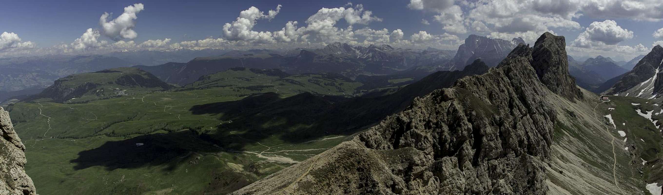
 Panorama of the Rosengarten Group from Grosser Rosszahn
In 1974 the complete region of Schlern / Sciliar and Seiser Alm / Alpe di Siusi was coverted into a natural park. The park contains some 6400ha. Within park boundaries any building activities are prohibited. Flowers, berries, mushrooms, minerals have to be left in their environment. Camping is prohibited and cars have to be parked in the official lots. Moreover between May and October the roads may not be used for car traffic - the hotels, huts and farms are excepted, however.
Many of the roads and trails on Seiser Alm / Alpe di Siusi are open for mountain biking. You will get as far as Tierser Alpl to the south of Roßzähne / Denti di Terrarossa.
Accommodation
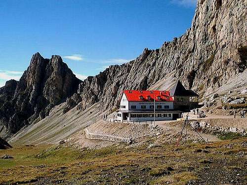 The Tierser Alpl Refuge at the base of Grosser Rosszahn
Eisacktal / Valle Isarco
Val di Fassa
Grödner Tal / Val Gardena
- www.valgardena.it
www.groeden.info
- St. Ulrich / Ortisei
- St. Christina / Santa Christina
- Wolkenstein / Selva di Val Gardena
You can find a number of campgrounds in Val di Fassa:
- Marmolada
via Pareda
Canazei
Tel.: +39 0462.601660
Fax: +39 0462.601722 - Catinaccio
via Avisio 15
Pozza di Fassa
Tel.: +39 0462.763305
Fax: +39 0462.763501 - Soal
via Dolomiti 32
Pera di Fassa
Tel.: +39 0462.764519
Fax: +39 0462.764609 - Vidor
Località Vidor
Pozza di Fassa
Tel.: +39 0462.763247
Fax: +39 0462.764780
Weather Conditions
Maps & Books
Books:- Vie Ferrate
- Klettersteige Dolomiten
H. Höfler, P. Werner
Rother Verlag
ISBN: 3 7633 3096 8
- Hülslers Klettersteigführer
E.E.Hülsler
Bruckmann Verlag
ISBN: 3 7654 4161 9
- Klettersteige Dolomiten
- Dolomiten
P. Fleischmann
Kompass Verlag
ISBN: 3 8705 1409 4
- Dolomiten 3
F. Hauleitner
Rother Verlag
ISBN: 3-7633-4060-2
- Dolomiten 4
F. Hauleitner
Rother Verlag
ISBN: 3-7633-4061-0
Maps:
I have been using the maps by Kompass Verlag. There are several which differ in scale:
- Val di Fassa, Marmolada, Gruppo di Sella
Kompass Map WK 686
ISBN: 3 8549 1768 6
Scale: 1:25000
- Sellagruppe / Gruppo di Sella
Kompass Map WK 59
ISBN: 3 8549 1066 5
Scale: 1:50000
- Val Gardena & Alpe di Siusi
Tabacco Map 05
ISBN: 978-8883150050
Scale 1:25000