
-
 3217 Hits
-
 76.66% Score
-
 7 Votes
|
|
Route |
|---|---|
|
|
47.28473°N / 10.12916°E |
|
|
Download GPX » View Route on Map |
|
|
Hiking |
|
|
Summer, Fall |
|
|
Half a day |
|
|
Hike - T4 by SAC Scale |
|
|
Introduction

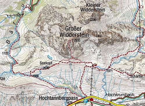
On the parent (mountain) page of Grosser Widderstein a lot has been said also about its normal route. But I think that such a nice mountain deserves a bit more structured approach, so here I am describing the route on a separate page - and with some more details. Not speaking about harder climbs, Widderstein has in its summital part only one route (normal ascent), which goes by the big south gorge. Below, on its entry all approach paths join. The shortest ascent comes from Hochtannbergpass, longer ones are coming from the north, from Kleinwalsertal.
General Information
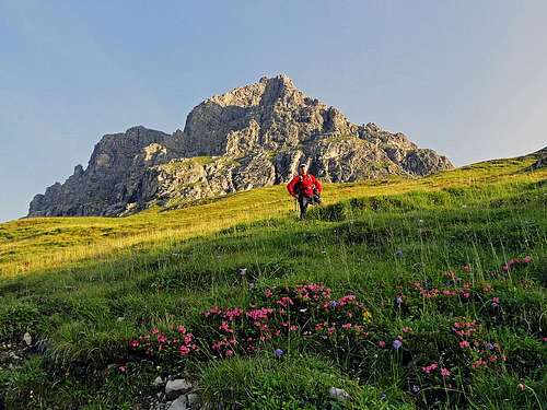 On the lower, grassy slopes of Widderstein
- Character: Grosser Widderstein normal route is a wonderful ascent for experienced hikers. In lower areas there are nice, blossoming pastures, above 2000 meters of altitude there is great rock scenery. The southern side ridge is very picturesque. At first it borders with a high vertical wall the big gorge on its eastern side, later, from above, the ridge excells with its sharpness. The views from the summit of Grosser Widderstein are very broad.
- Difficulty: It's still a hiking tour, on the Swiss Hiking Scale its difficulty would be graded T4. There are no protection devices on the route, so a safe step is needed and we have to overcome many rocky steps in easy climbing. On UIAA scale the difficulty of climbing nowhere exceeds degree I.
- Orientation: The route is well marked - through the gorge follow the blue marks which go by the best passages over rocks. See also the GPX track in the header!
- Exposition: The slopes of the gorge, and later of the summit ridge are quite steep, but nowhere very exposed. Still, on many places making a wrong step could be fatal. The route is not suitable for people who suffer from vertigo.
- Objective dangers: In the gorge there is a considerable danger of falling stones. They could come by natural reasons, or could be triggered by many climbers in the route - well, the latter is not any more an objective danger.
- Best season: Summer months, due to the south exposition this means normally from June till October. But the normal route is also a nice winter tour (requires good conditions and full winter equipment) and in perfect conditions can be also done as a ski tour.
- Best time of a day: It's good to come early, so the ravine is still in shadow. We started the tour at 7:00 and had a privilege to be on top 30 minutes alone. Then, going down, we met in the gorge at least 30 climbers.
- Gear: Good shoes and poles. Climbing is easy so I used poles all the way up and down. Still, most visitors put them in the gorge in their backpack. Due to rockfall, also a helmet is recommended.
- Tour start: Hochtannbergpass, 1676 m. Big, free parking place there (2014). The pass is on the road which connect the upper valley of Lech (Warth town) with Bregenz.
- Highest point: 2533 m.
- Altitude gain: cca 870 m.
- Time for ascent: 2 h 30 min. With the descent, it's altogether a half day tour.
Route Description
From the parking place on the road pass we go good 100 m by the road back towards Warth, until at a big wooden hut inscriptions direct us on a good path, which deters uphills, towards Widderstein Huette. To attract visitors it is written 45 minutes till there, but an average hiker will need for those 350 meters of altitude around one hour.
 Morning above Hochtannbergpass Morning above Hochtannbergpass |  Hochtannbergpass and Braunarlspitze Hochtannbergpass and Braunarlspitze |
The path goes in many turns across the grassy slopes, all the time towards the north. Towards the south and east we have a nice view over the road pass and along the valley towards Warth and on the surrounding mountains.
 Widderstein Huette Widderstein Huette |  The view from Widderstein Huette The view from Widderstein Huette |
At Widderstein Huette, 2009 m, we turn left, towards the west. A well marked path goes at first almost horizontally across the grassy southern slopes of Widderstein. Then it soon branches. The left, lower branch, continues horizontally on Hochalppass. Our path is the right one, which goes more steeply up the slope, towards our mountain. Despite ascending considerably, the path still crosses towards the left, until it reaches the mouth of the big Widderstein south gorge (some 15 minutes from the hut till here). Till there from Hochalppass also the approach path comes. The inscription warns us that the continuation of the route is more difficult.
 A balcony in the gorge A balcony in the gorge |  Looking up the gorge Looking up the gorge |
In the beginning the feeling in the big gorge is a bit anxious and also the views up are quite scary. But the path keeps finding considerably easy passages over the rocks. You only need to be careful to set every step safely and to hold solid rocks. In the lower part the path follows the gorge bottom, but then soon starts using the left slopes (looking up). There it reaches a nice balcony with a fw big ciarns, but it's much too early to think of a rest. So we continue by a steep, rocky slope up. It is a good advice to follow the marks strictly, because they avoid as much as possible climbing over rocky steps. Instead, they use narrow ledges, going left and right. But some climbing is needed despite of that. In its middle the route approaches the bottom of the gorge again. There it goes through a narrow rocky passage, where we can find even one or two rusted, useless peggs in rocks (the only ones).
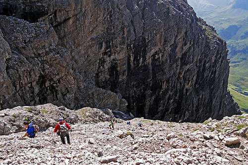 The middle part of the big gorge The middle part of the big gorge | 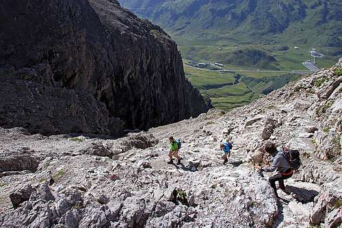 The upper part of the big gorge The upper part of the big gorge |
Above, the path avoids the gorge bottom again towards the left. There we already see the summit with its cross and the western summit ridge above us. The route goes in turns directly up, until it gains the summit ridge. Nice views open towards the north.
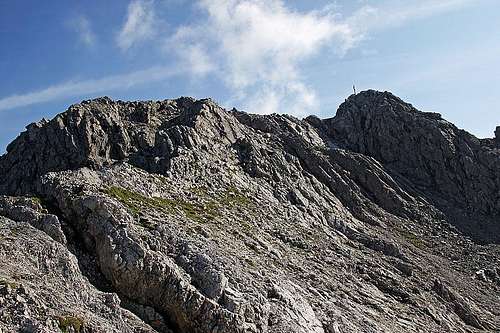 Summit (W) ridge
On the west ridge we turn right and continue by easy scrambling. We follow the ridge or go just a bit right below it - until we reach the highest point.
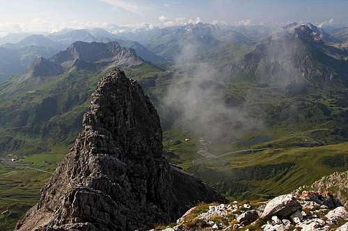 Southern views Southern views | 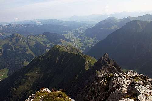 Northern views Northern views |
We descend by the same route till the gorge entry. From there we can continue directly (via Widderstein Huette) down to the road pass, or we can decide to do a short round tour. The latter goes towards the west on Hochalppass, and only from there down to Hochtannbergpass.
External Links
Big panorama: http://www.hoehenrausch.de/panoramabilder/bilder/gross/widderstein.jpg A nice video: http://www.vorarlbergvonoben.at/video/DE/222/Widderstein