
|
|
Route |
|---|---|
|
|
40.79290°N / 110.3666°W |
|
|
Scramble / Bouder hop |
|
|
Less than two hours |
|
|
class 2 |
|
|
Approach
Begin at Gunsight Pass, which is conveniently accessed from Henry's Fork FS trail 117 (the main "Kings Peak trail"). It is approximately 10.5 miles from the trailhead for Henry's Fork to Gunsight Pass. See here for details to get to Henry's Fork trailhead.
Gunsight pass can also be reached from the Uinta creek trailhead, but it would be preferable to use the highline trail towards Anderson pass to get to West Gunsight/Dome, then peel off towards the peak above 12000 feet.
Route Description
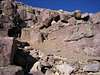
From the windbreak on Gunsight Pass, look for some cairns that are lined up about 50 feet or so peeling off of the southwest side of the trail. There isn't necessarily a defined trail splitting off of the main one, so watch for these cairns. Once you spot them, follow them until you can see the established trail heading up the hillside. There were three cairns visible that showed the way to the footpath when I was there in September, 2005. Once past the third cairn, the route was easily visible.
A snowfield may be present in higher snow years (such as 2005) just immediately past Gunsight Pass. You may have to cross it early in the season. Keep an eye out for a worn path and cairns that lead up towards a less cliffy section of hillside. Eventually, the route becomes a little confusing, but there are several ways one could go. Cairns are placed along at least two routes that ascend through small cliffs to the east side of the mountain. It looked like one could bypass these steep boulder sections by continuing along the hillside to the south until rocks that aren't as steep are uphill.
Once past the steep boulders/small cliffs (many cairns dot the routes through this), you may want to mark a GPS waypoint, or at least take a good hard look at your surroundings. When coming down, the route isn't nearly as easy to see. Continue up the boulders to the west, and make your way up the hill until you reach the top. For what it's worth, the boulders seemed a little less stable in their placement on the hillside than what I remember on Kings peak.
From Gunsight Pass to the top, it is under a mile. I would imagine a hiker that is in good shape could easily make it in an hour. Personally, I made it in 45 minutes up (good exertion), and probably 45-55 minutes down to Gunsight Pass.
 |  |  |
Essential Gear
10 Essentials, decent weather. Trekking poles seemed to get in the way for me once the boulder hopping started at around 12300 feet or so.
In winter, avalanche knowhow and gear for it would be preferable. In spring, crampons and an axe.
Miscellaneous Info
If you have information about this route that doesn't pertain to any of the other sections, please add it here.