Inspiration and then reality
I had spent a great weekend in the Fields Oregon area peakbagging with some outstanding guys, who also happen to be SP members. After bagging Nevada's Duffer Peak and the Jackson range HP summit, along with Pueblo Mountain near Fields, I thought i was in great shape to do just about anything. And I was mostly right
In checking out the new pages on SP, I found that mountaingazelle had posted a page for Gunsight Peak and had found a way up that wasn't a trespassing situation. That was all the inspiration I needed to put together a plan to go and get it, one of
Utah's top 100 prominence peaks, #59 on the list overall. So the trek to get Gunsight Peak was about to begin.
Early thursday morning, I left Lehi at 5 a.m. in an attempt to beat the Salt Lake City traffic and in that I was somewhat successful. I was surprised by all the traffic at that time of the day but at least it wasn't overly stifling.
I made good time up to the turnoff for Clarkson and followed the road directions as given by MountainGazelle and they were spot on. Parking at the little parking area was as she described and soon I was signed in at the register and ready to head up the jeep road to the north.
How tough could this be I asked myself. Only 8 miles roundtrip and 2500 feet of elevation gain. I should be up there in two hours, two and a half tops. This should be a piece of cake.
Not far up the road as the road disappeared and the hillside steepened, the mosquitos began to extend their wonderful greeting. Buzzing in my ears and
trying to get a free drink, I dispatched many of the blood suckers to the mosquito promised land. I knew that bug free part of the year was now over and yet in Oregon and Nevada, I hadn't seen even one mosquito so the reality aspect of summer hiking was now upon me.
The South Ridge
The first 2 miles went rather well and I covered that distance and a good chunk of the elevation gain in an hour and a half. I began calculating in my head that I had half the hike already done and could expect to be on top in another hour and a half. How wrong my calculation turned out to be. The south ridge went from being friendly to being a bit of a rascal as I now faced many ups and downs and decisions on whether to go left, right or try and stay on the ridge top. Well, staying on the ridge top wasn't often an option so I had to make forays into the bushes, find ledges and otherwise make my way. I found solace in seeing footprints on many of the choices I made which made me realize that mountaingazelle had made many of the same decisions. The problem with all of this was that time was flying by and I wasn't covering the ground very rapidly.
Of course, every time I had to slow down, which was all the time now, the mosquitoes came out to make my acquaintance. Arrggghhh, I hate those things but they are part and parcel of the mountains at this time of year. I remembered why I really like fall hiking although I don't like being in the areas where hunters are trying to bring home dinner. At a place I called the "notch", a secondary ridge came up to join the south ridge and this secondary ridge became the route to get over to where I wanted to go. The trouble is, while it looked easy on the pictures I had seen, there was nothing easy about it as you couldn't stay on the ridge top hardly at all. Getting onto this ridge also meant an elevation loss which would need to be
regained on the return trip.
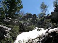
The clock was really running on me now and I began to realize that I wasn't going to summit in three hours, I'd be lucky to summit in four. Finally the routefinding on the subsidary ridge was over and I have to admit I actually enjoyed figuring out which way to go was keeping me interested and involved. I dropped off the ridge into the trees for a bit and then contoured around to the east side of the summit I wanted. Rather than be smart and just go up the east slope, I got cutesy and decided to go up on the north side. Well, thats when I got into some snow and that slowed me down and cost me more time than was necessary. The smart way would've been going up the east side but then, few people would call me smart for being out here by myself anyway.
I finally made it up through the last snow band and found where the summit was hiding. First I hit all the possible high spots and when I found the Benchmark and register box, I knew I had reached the promised land.
Views were available, if not from the summit then from various spots along the summit ridge itself. Great views, wonderful views in all directions that made it all worthwhile. I looked at my watch, 4 hours and ten minutes to get up here and so I was half done with this hike. I sat down, ate some lunch, made a register entry and called my wife and a friend who I generally call from most summits, the guy who got me into this peakbagging stuff, SP member RFBolton. He always gets jealous when he finds out that I am out playing and he is stuck in the office where he works. That is kind of mean of me but it also isn't a bad idea to let someone know where I am at.
The return trip took almost as long as I found out that this mountain is not a "gimme", you have to earn it, every step of the way (while being chased by mosquitoes). I did almost step on two snakes along the way but neither was a rattler. Rattlers are up there so you need to pay attention to where you put your hands and feet. MountainGazelle mentioned to me that she had
seen two rattlers during her visit not that many days before.
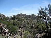
![On the way back...]() On the way back
On the way backMore pics and some afterthoughts
Most of my pictures look just like the ones the mountaingazelle posted so I
would defer to those pics that she has posted on the main page for Gunsight Peak. I also have posted a few additional pictures not shown in this trip report so again, I would recommend you take a peek at the picture section.
This is a great little mountain, very close to the Idaho border and its twin summits provide outstanding views in all directions. While I didn't go to the south summit, had I more time or if I ever revisit this peak, I will definitely go over and get acquainted.
Comments
No comments posted yet.