
-
 17589 Hits
-
 92.59% Score
-
 39 Votes
|
|
Mountain/Rock |
|---|---|
|
|
63.98330°N / 19.1667°W |
|
|
3700 ft / 1128 m |
|
|
Overview

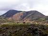
Háalda is the name of one of the higher peaks located in the Fjallabak Nature Reserve in south-central Iceland. This 47,000 hectare preserve was created in 1979. The name, Háalda, means "high smooth mountain" and it pretty much says it all. Háalda appears as a brownish hump rising above everything in the Landmannalaugar area of the park. Geologists believe that Háalda is actually one peak on the rim of a caldera with Torfajokull, a large glaciated region on the southeast of the preserve, being the central volcano. Landmannalaugar is an area and campsite within the Fjallabak Nature Reserve. This area is a hidden gem amid the arid desert of the Icelandic interior highlands. The valley it sits in receives enough moisture to sustain plant and animal life while the geology of this area is the largest rhyolite area in Iceland. (Click here for some geologic information) What this means is you get high mountains of every color from red to yellow to orange to tan to brown to grey and blue and even some light green. Rhyolite gets this way from geothermal activity altering the minerals in the rocks. The valleys are filled with thick green moss-covered lava and meadows with lots of rivers, ponds, lakes and wildflowers. Among all of this are also hot springs, sulphur vents, mudpots, etc. It all goes into what is an amazing place. Animal life includes trout-filled lakes, sheep (well, they are EVERYWHERE in Iceland) and birds including large swans.
The price you pay for this is an incredibly small window of time in the year in which you can actually get there. Roads in this area are typically only open in July and August and even then, you will need a 4WD with a decent amount of clearance as you will cross up to half a dozen fords as well as travel on rutted dirt tracks.
Háalda sits on the opposite end of a valley from the campsite of Landmannalaugar across a moss-covered lava bed and a meadow. The hike to the summit takes you through all this and past a small hot spring, some large sulphur vents towards a beautiful waterfall at the far end of the valley. From there you will climb some ridges to attain the path to the summit. Views are amazing and full of color. It's a non-technical hike that will take about half a day and from the summit you have the option of returning via the same meadow, a high ridge or down into alpine lakes and sulphur vents.
It's supposedly a fairly popular hike although no one was on the trail while I was there. Landmannalugar was also said to be the site of many baptisms in the hot springs during the Conversion from paganism to Christianity.
 |  |  |  |  |
Getting There
Getting to Iceland involves flying Icelandair. All international flights fly into Keflavik Airport which is out 40 kms. west of Reykjavik on the Reykjanes Peninsula. From there you can rent a 4WD at one of the usual companies (Budget, Avis, Hertz, etc.). MAKE SURE you don't get stuck with a "touring" 4WD or you will end up with an all-wheel drive station wagon or the like that will NOT be sufficient in getting you to Landmannalaugar.For information on how/where to get supplies, please refer to the Getting There section of the Hekla page.
From Keflavik Airport, take Road 41 (paved) to Reykjavik and Highway 1 (the Ring Road). Take Highway 1 east 79 kilometers to Road 26. Go north on Road 26 for 47 kilometers to Road F225. Turn right on F225 and proceed 41 kilometers on rough track into Fjallabak Nature Reserve. I forded no less than 5 streams/rivers in a Toyota RAV4 and it was sufficient (barely) to get through them. Make sure you are familiar with driving off-road in these conditions. Typically, when coming to a river, keep it in first gear and don't go too fast or too slow. You need enough momentum to get through but you don't want to splash too much and risk getting water in the intake of the engine or you are done for. This is not a place you want to get stuck although in July and August there will be someone coming along before too long (hopefully).
Just after you pass a large lake called Frostastaðavatn, take a right following the sign for Landmannalaugar. There is also a short stream to ford just before you get to camp that you will want to stop and make sure no one else is coming through at the same time.
Please note that the last gas available is about 70 kms. back on Road 26. Plan accordingly
There is also a road in from the east to Landmannalaugar (F208) but this route has many more fords and is only for special 4WD vehicles (high lift kits, oversize tires, carrying your own gas in, etc.). Since I doubt anyone will really go that way, I will not describe the route here. If you are interested in it, please obtain the map described in the section below.
Another option is a bus service from Reykjavik to Landmannalaugar. Click here for information
Red Tape
There are no permits or fees to climb Háalda. There is only one place to camp though and it does require a fee. Please see the Camping section for details.When To Climb
The area is typically only accessible in July and August. Outside of the time temperatures are much lower and roads are closed. Too early in the season and rivers are too high also and impassable.Camping
You may only camp in one of three campsites within Fjallabak Nature Reserve:The closest is obviously Landmannalaugar and is where the trailhead is. There is a hut there and a large open area for camping beneath dramatic yellow peaks. The fee is 600 kronur (about $8) per night and no reservations are needed. They do have showers, a cooking area, restrooms, sinks and a popular hot spring where people soak and bathe. This is the campsite where you want to be.
Other campsites are Landmannahellir (which you pass on the road in in the northwest section of the Reserve, also the name of a mountain there) and Hraftinnusker (name of a mountain and campsite) in the southern section of the Reserve.
 |  |
Mountain Conditions
The Icelandic Touring Association runs a hut at Landmannalaugar and is the best bet to get information about the conditions. The link above take you to their site or you can email them at: fi@fi.isOther contact information for them is:
telephone 354(country code) 568-2533
fax 354(country code) 568-2535
Link for Road Conditions
Link for weather in Iceland
Maps
The best map you can get for travel in Iceland that shows all gas stations, campsites, topo lines, services, etc. can be located and obtained here. I would strongly recommend getting this map before going to Iceland.At the hut in Landmannalaugar, you can purchase a trail map that shows the route to the summit.
Sketch of the area