The Trip Begins...
During my ongoing quest to summit Washington's county highpoints, Mount Stone has been on my "to do" list for a while. The peak was not really on Gimpilator's radar, but in addition to me he had two other friends who wanted to go so he decided to join. Gimpilator and I left on Friday night, but due to a short stretch of Forest Road 25 approximately 10.4 miles in being too rough for my passenger vehicle we stopped there. It was a little after 10:00 PM, and we spent the next hour snacking and getting ready to car-camp (or, for the G-Man, bivy behind the car).
Dave and Robbin met us at the car the next morning, and then drove us in Dave's truck the remaining 1+ mile to the Putvin Trailhead. This was my first time meeting Dave, although I had hiked with Robbin several times, and Gimpilator had hiked with both people multiple times. Due to many people telling us how long it might take to reach the summit of Mount Stone, as well as the 5100'+ elevation gain, we wanted an early start. We began hiking at 4:45 AM. We reached the Lake Of The Angels at 7:00 AM, which we were satisfied with considering that 2/3 of our elevation gain for the trip was already done. We were shocked with the amount of campers on the other side of the lake, and several mountain goats were roaming around those campsites.
![Lake Of The Angels]() Arriving At The Lake Of The Angels
Arriving At The Lake Of The AngelsThe Real Climb Begins...
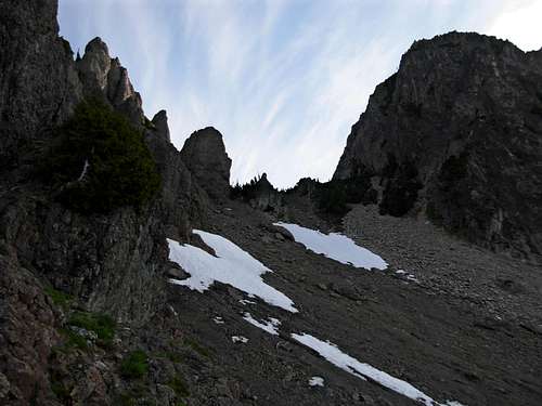
From where we reached the lake, we saw a faint old path that headed generally NNE towards Saint Peters Gate. We followed it as best we could, although it frequently seemed to disappear. The route direction was obvious, however, so we were able to approach Saint Peters Gate without much delay. Before reaching Saint Peters Gate, we headed steeply uphill alongside a cliff and relocated a path above. We then side-traversed west along several slopes of loose rocks, and then briefly north until reaching a small saddle on the west side of Mount Stone.
![Ascending To Mount Stone]() Ascending Uphill From Lake Of The Angels...
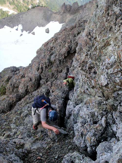
Ascending Uphill From Lake Of The Angels...![Chasm On Mount Stone]() Gimpilator Travels Through Rocky Chasm South Of Mount Stone...
Gimpilator Travels Through Rocky Chasm South Of Mount Stone...![Saint Peters Gate]() Approaching Saint Peters Gate...
Approaching Saint Peters Gate...![Gimpilator On Mount Stone]() Gimpilator Ascends West From Near Saint Peters Gate...
Gimpilator Ascends West From Near Saint Peters Gate...
From the small saddle, we headed east up a steep rock chimney until we were overlooking a small snow-covered upper basin. It was from here that we got our first view of the Mount Stone summit block across the basin. Snow filled the basin, but a moat had melted away from the north rock cliffs of the basin enough to walk through. It was interesting to walk through the tall moats, with a rock cliff on one side and hardened snow wall on the other side. We soon reached the base of the summit block.
![Having Fun In Mount Stone Moat]() Traveling Through Upper Basin Moat...
Traveling Through Upper Basin Moat...![Having Fun In Mount Stone Moat]() Having Fun In Upper Basin Moat...
Having Fun In Upper Basin Moat...![Approaching Mount Stone Summit Block]() Approaching Summit Block...
Approaching Summit Block...To The Summit And Back Again...
At the summit block, we followed the obvious path halfway up, until the path seemed to go left or right. We took the less-obvious right path up a brief steep rock groove, and then the route was simple after that. From the groove, we were on the summit within minutes. We reached the summit at 9:15 AM, only 4h30m from the trailhead, which we thought was much faster than most people. The views from the summit were great, but we were glad to have started so early to get there. Clouds from an approaching storm system were swirling inward all around us within 30 minutes of our arrival. I was hoping to find a summit register, but alas, there was none to be found. This was my 31st Washington County Highpoint, so I only have eight remaining. After 45 minutes at the summit resting and snacking, we were on our way down at 10:00 AM.
![Gimpilator On Summit Block]() Gimpilator On The "Crux" Section...
Gimpilator On The "Crux" Section...![Exposure On Mount Stone]() It Looks Worse Than It Probably Actually Is...
It Looks Worse Than It Probably Actually Is...![Mount Stone Scramble]() The "Crux" Scramble Section Of The Summit Block...
The "Crux" Scramble Section Of The Summit Block...![Mount Stone Summit]() Having Fun At The Summit. WA CoHP #31!
Having Fun At The Summit. WA CoHP #31!
During our descent, we saw a fisher pop out from a snowbank, after some rocks tumbled down towards the snowbank from our steep descent that must have spooked the animal. Later, when we were below Saint Peters Gate, Robbin, who was only 5' behind me, accidentally dislodged a large rock. I heard her shout "ROCK!" but before I could react it slammed into my left calf muscle. The rock had one pointed side, so of course that was the side that hit me. Thank goodness I was only 5' away from Robbin, so the rock did not have much time to gain acceleration before hitting me. After wincing in pain for a few moments, I hobbled down the mountain as my calf muscle stiffened. I wanted to keep moving while the adrenaline was still pumping... I expected the muscle to continue tightening-up later on. We reached the Lake Of The Angels and were greeted by 11 mountain goats. Only in the Olympic Mountains do I regularly see mountain goats.
![Above Lake Of The Angels]() Descending Back To The Lake Of The Angels
Descending Back To The Lake Of The Angels![Goats At The Lake Of Angels]() Mountain Goats At The Lake Of The Angels
Mountain Goats At The Lake Of The Angels![Goats At Lake Of The Angels]() More Mountain Goats...
More Mountain Goats...
We reached the trailhead at 2:15 PM, only 4h15m from the summit, which again was quicker than we had originally anticipated. We celebrated our summit accomplishment by driving north along Highway 101 to the Halfway House Restaurant in Brinnon. The restaurant service leaves much to be desired, but the pies are always great.
Overall, it was a great trip, great mountain, and great team.
Addressing The Mount Stone Rumors And Myths
Now, to disspell some rumors and myths:
-> Although some people suggest a passenger vehicle can make it all the way to the Putvin Trailhead, I personally would not recommend it at this time. Low-clearance vehicles would have trouble with washout/formely bermed area 10.4 miles in, which sucks because it is such a short area. Also, there is a small washout 8.8 miles in that some passenger vehicles might have issues with, especially if nothing gets done about it.
-> The so-called "crux" of the summit route is supposedly halfway up the summit block, when a person could go left or right. The left route might initially look obvious, but it is very exposed and not recommended. The right route is at a skinny groove in a tall boulder, which needs to be climbed up and over, but does not have much exposure and we thought was much simpler than implied. In fact, I would say the loose rocks of the chimney section might be more dangerous than that "crux" part.
-> Some people claim the "crux" is YDS Class IV. If you take the rightside route rather than the leftside route, then it is YDS Class III scrambling. Not the easiest but also not the hardest in that category.
Comments
No comments posted yet.