
-
 41336 Hits
-
 93.67% Score
-
 44 Votes
|
|
Area/Range |
|---|---|
|
|
21.46670°N / 157.98331°W |
|
|
Hiking |
|
|
Spring, Summer, Fall, Winter |
|
|
Geography
 Map - Oahu
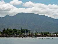
Oahu, known as ”The Gathering Place” is the third largest of the Hawaiian Islands. The state capital Honolulu is located on the southeast coast. Including small offshore islands it has a total land area of 596.7 square miles (1,545.4 km2), making it the 20th largest island in the US. In greatest dimension, this volcanic island is 44 miles (71 km) long and 30 miles (48 km) across. The length of the shoreline is 227 miles (365 km). Oahu is of volcanic origin and consists mainly of a broad interior valley situated between the Waianae and Koolau ranges—two parallel mountain ranges trending southeast-northwest. The Waianae Range is the higher of the two, reaching a maximum elevation of 4,025 feet (1,227 m) at Kaala peak. Geographically, Oahu is divided into six regions - Honolulu, East Oahu, Central, Leeward, North Shore and Windward. The central regions and the eastern coastline enjoy a wetter climate, resulting in lush, green backdrops for dramatic rocks and ridges. On the northwestern coastline the climate is warmer and drier; steep valleys and near-vertical drops are interspersed with exposed, earth-colored peaks and carved outcroppings. The island is home to about 900,000 people.
History
The old Kingdom of Oʻahu was once ruled by the most ancient Ali’i in all of the Hawaiian Islands. The first great king of Oʻahu was Mailikukahi, who was followed by many generations of monarchs. Kualii was the first of the warlike kings and so were his sons. In 1773, the throne fell upon Kahahana. In 1783 Kahekili II, King of Maui, conquered Oʻahu and deposed the reigning family and then made his son Kalanikupule king of Oʻahu. Kamehameha the Great would conquer Kalanikupule's force in the Battle of Nu’uanu. Kamehameha founded the Kingdom of Hawai’i with the conquest of Oʻahu in 1795. Hawaiʻi would not be unified until the islands of Kaua’i and Ni’ihau surrendered under King Kaumualii in 1810. Kamehameha III moved his capital from Lahaina, Hawaii, Maui to Honolulu, Oʻahu in 1845. ‘Iolani Palace’, built later by other members of the royal family, is still standing, and is the only royal palace on American soil.
Oʻahu was apparently the first of the Hawaiian Islands sighted by the crew of HMS Resolution on 18 January 1778 during Captain James Cook’s third Pacific expedition. Escorted by HMS Discovery, the expedition was surprised to find high islands this far north in the central Pacific. Oʻahu was not actually visited by Europeans until 28 February 1779 when Captain Charles Clerke aboard HMS Resolution stepped ashore at Waimea Bay. Clerke had taken command of the ship after Capt. Cook was killed at Kealakekua Bay on February 14, and was leaving the islands for the North Pacific.
The opening battle of World War II in the Pacific for the United States was the Imperial Japanese Navy preemptive attack on Pearl Harbor, Oʻahu on the morning of December 7, 1941. The surprise attack was aimed at the Pacific Fleet of the United States Navy and its defending Army Air Corps and Marine Air Forces. The attack damaged or destroyed twelve American warships, destroyed 188 aircraft, and resulted in the deaths of 2,403 American servicemen and 68 civilians.
Mountain Ranges

Ko’olau Mountain Range
Koʻolau Range is a name given to the fragmented remnant of the eastern or windward shield volcano of the island of Oahu. It is not a mountain range in the normal sense, because it was formed as a single mountain called Koʻolau Volcano (koʻolau means "windward" in Hawaiian). What remains of Koʻolau is the western half of the original volcano that was destroyed in prehistoric times when the entire eastern half—including much of the summit caldera—slid cataclysmically into the Pacific Ocean. Remains of this ancient volcano lie as massive fragments strewn nearly 100 miles (160 km) over the ocean floor to the northeast of Oʻahu. The modern Koʻolau mountain forms Oʻahu's windward coast and rises behind the leeward coast city of Honolulu — on its leeward slopes and valleys are located most of Honolulu's residential neighborhoods.
The volcano is thought to have first erupted on the ocean floor more than 2.5 million years ago. It eventually reached sea level and continued to grow in elevation until about 1.7 million years ago, when the volcano became dormant. The volcano remained dormant for hundreds of thousands of years, during which time erosion ate away at the initially smooth slopes of the shield-shaped mountain; and the entire mass subsided considerably. The highest elevation perhaps exceeded 3,000 metres (9,800 ft); today, the summit of the tallest peak, Puʻu Konahuanui is only 3,100 feet!
After hundreds of thousands of years of dormancy, Koʻolau volcano began to erupt again. Some thirty eruptions over the past 500,000 years or so have created many of the landmarks around eastern Oʻahu, such as Diamond Head, Hanauma Bay, Koko Head, Punchbowl Crater, Tantalus, and Aliapa ‘akai. Geologists do not always agree on the dates of these more recent eruptions, some dating them to around 32,000 years ago, others to as recently as 10,000 years ago. Geologists believe that there is at least a remote possibility that Koʻolau volcano will erupt again.
Waianae Mountain Range
Waiʻanae Range (sometimes referred to as the Waianae Mountains) is the eroded remains of an ancient shield volcano that comprises the western half of Oahu. Its crest, at Mount Ka’ala, is the highest peak on Oʻahu.
Like the neighboring Ko’olau, the Waiʻanae Range is not a mountain range in the sense most people are familiar with, as the mountain range as a whole was created from a single volcano.
The oldest lavas dated from the volcano are about 3.9 million years old. About 3.2 million years ago, the volcano's activity changed, the rate of eruption started to decrease and the composition of the lava erupted from the volcano changed. The volcano is thought to have last erupted about 2.5 million years ago.
When active, the Waiʻanae volcano's center of activity was at present-day Lualualei Valley. Intense erosion on the western flank of the mountain has destroyed much of those flanks. Thus, the mountain today is much smaller than it was when the volcano was active.
Interestingly, while the western part of the mountain has been destroyed by erosion, the eastern part is still in a youthful stage of erosion. This is considered somewhat strange by some geologists since the western part of the volcano is on the leeward side of the island; thus, most rain falls on the eastern side of the volcano. Given this information, more erosion would be expected on the eastern portion of the mountain. One theory to explain this odd erosion pattern is that a large landslide cut away the western portion of the volcano. The faults from this huge landslide weakened the rock, making the western part of the mountain much more susceptible to erosion than the eastern side.
Beaches (selected)
| Hanauma Bay | Waikīkī Beach | Kailua Beach | Waimea Bay |
|---|---|---|---|
 |
 |
 |
 |
Attractions (selected)
| Diamond Head | Waimea Falls | North Shore | Mokolii Island |
|---|---|---|---|
 |
 |
 |
 |
Weather
At sea level the average afternoon winter temperature is around 75°F during the coldest months of December and January. August and September are the hottest summer months with temperatures in the low 90s. The average temperature is 75°F - 85°F. Due to the prevailing trade winds, most rainfall hits the north or northeast facing shores, leaving the south and southwest areas, including Honolulu and Waikiki, relatively dry.