
-
 29931 Hits
-
 87.76% Score
-
 25 Votes
|
|
Mountain/Rock |
|---|---|
|
|
21.51070°N / 158.1452°W |
|
|
4040 ft / 1231 m |
|
|
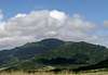
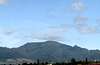
Overview
Ka'ala, at 4,040 feet, is the lowest elevation summit of the four main Hawaiian islands but the second most difficult to attain. A road leads up to the top but in the security conscious world of post 9/11 there is no public access by vehicle or even by foot up the 7 1/2 mile road constructed in the 1940’s leading to an impressive array of FAA control center gear on one closely guarded and gated compound in one small corner of the summit plateau. This leaves at least four trail options that I could find but only one that has no access issues or isn’t a long and tedious up and down mud-fest to the summit.The peak, unlike all other mountains on the island of Oahu, is more-or-less flat-topped and conjures up visions of Sir Arthur Conan Doyles “Lost World” with it’s bonsai covered swamp and marsh populated with endemic species of ferns, plants and animals, (many of them endangered). You will hear the songs of birds unlike any you have ever heard since many of them live here and nowhere else in the entire world. On the way up the trail you may hear the bellowing of wild boars in the deep forest below and mist will periodically engulf you and then suddenly dissolve to reveal fantastic scenes of ferns towering as high as twenty feet and plants, trees and other vegetation unlike anywhere else.
The summit plateau is surrounded on all sides by cliffs and ridges and provides views of most of the island from its lofty summit but apparently is visited only rarely due to the limited and relatively difficult access. The Hawaii state parks department, charged with maintaining the forest preserves in the islands, is not particularly helpful or encouraging but stops short of outright refusing the public access to this peak. As a result, there is apparently no trail maintenance and no signage either making this a hike you will probably have all to yourself: A rarety on the small, overcrowded Island of Oahu.
(Page updated 6/27/06 with help from Brian Jenkins.)
 |  |  |  |
Getting There
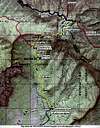
First, fly to Honolulu, get settled, rested and relaxed. This is a vacation, after all, so enjoy yourself for what could be a somewhat aggravating time in navigation due the problems of traffic, route finding and general aggravation due to crowding, especially severe in my experience on this island. I found that freeways exits seldom have corresponding on ramps, street signs are misleading or absent, and traffic signals are not computer or sensor controlled resulting in longer travel times than would otherwise be necessary. This, combined with the fact that about one million people live on this relatively small island, makes traffic a pain, even for locals who know the routes well. That having been said, my advice is buy a good map, study your intended routes well in advance, and expect delays.From Honolulu, take H1 west. Continue west on route 93 for about 6.6 miles after the freeway ends and continue to Waianae town. Just after the Waianae shopping mall take a right on Waianae Valley Road. After 2.5 miles the road splits into separate single-lane tracks: Take the left one marked: Dead End. Carefully continue another 1.1 miles and park at the locked gate.The first mile or so is up this one lane mostly paved water system access road. Once at the end of the road, take the obvious trail up the hill. After another ¾ miles you will encounter a shelter with a picnic table: continue up the ridge to the right. In a short distance, take the left fork away from the ridge trail. Follow this mostly traversing trail for about a half mile, crossing a dry stream bed along the way. Once at an area of native ti plants and another, very small (usually) dry stream crossing angle up the hill to the left of the stream. This path starts to climb steeply without benefit of switchbacks and reaches the ridge in another 1/2 mile. Turning right at the ridgetop, you will see the powerline crossing a few feet in front of you. Here’s where the route gets more interesting. Continue along the ridge in a direct line to the peak eventually getting to the first in a long series of fixed “ropes” consisting of all manner of garden variety materials: Nylon and polypro utility rope, dog leashes, phone cord and even a short section of cotton clothesline! Be careful, test pull beforehand and enjoy! Most SP-types could probably get up this class III/IV ridge without the assemblage of ropes but they are handy when the trail is wet and very handy for the steep, slippery downclimb: A slip and fall off the ridge could easily be fatal.
Once on top of the summit plateau there is a very handy boardwalk across the swampy wet summit plateau. This eventually leads to the FAA compound on the opposite side. On the left of the road leading into the enclosure find the unlocked gate that gives access to the grassy area just outside the compound. Continue around the outside to find the highest point and better views. This route is 7.2 miles RT with 3,500 vertical feet of gain.
In my experience so far, the trails of the islands of Hawaii lack one commonality with those of the rest of the US: Switchbacks. On this and all other trails I visited, switchbacks were rare so expect to trek up and down steep ridges, gullies and valleys.
 |  |  |  |  |
Red Tape
The route described needs no permits, fees, parking passes or other official entanglements but keep in mind the unfortunate fact of elevated car theft levels, especially for tourists’ rental cars, and leave nothing you can’t afford to lose in your vehicle. A good idea would be to opt for the “walk away” insurance coverage for the days you plan to leave a vehicle at any trailhead.When To Climb
The climate of Oahu is very mild and consistent so any time of the year will work. The summit plateau gets about 100 inches of rain in the average year but it’s warm rain that usuall falls in the late afternoon and evening. All-time record temperature range at the top is from about 40 degrees to less than 80.Note: Take special care to have plenty of water. This trek starts out at less than 600 feet elevation so expect summer temperatures at the trailhead of at least 75 degrees in the morning and 85 to 90 in the afternoon with very high humidity.
bechtt - Mar 28, 2012 4:34 pm - Voted 10/10
Dupont TrailI climbed the Waianae Valley Trail but copied this from a local blog site in case someone wants to try a different route (phone number handy for private property access.) "Aloha, just wanted to share you you that we did this trail last week. It was a difficult trail, especially dangerous when it was wet and muddy/slippery, but it was well worth the effort. The last 1,000 ft section was 'no hiking' indeed, it was all 'climbing' and you will be on your hands and knees hauling yourself up the many dangerously steep inclines. But once you get up to the top, you will feel a great sense of accomplishment and you will be proud of yourself. That is a great feeling and the view is magnificent! When you reach the gate of Kamananui Orchards adorned with "No Hiking" signs, you should really heed that sign. We met with one of the land owners ourselves and they are nice people who did not mind people on their land but they would like to be informed that you are coming. Think of it this way, if people keep climbing over your front gate, walk around your own home, and walk out your back gate, how would you feel as a home owner, especially if you have animals in your land? Really, please do call Randy or Mary at the Kamananui Orchard at 808-778-6014 and let them know that you will be coming at least 48 hours prior. If they are there when you arrive, they will probably tell you about the mac nut trees and other things they grow on their lands. When you are up the mountain on the rope/cable section, always check the rope before you use it. One rope broke on us. Don't wear your pretty brand name hiking clothing and equipment if you can't stand getting mud on them. If you are a fairweather hiker, leave your shorts at home and go for long pants, especially on a wet rainy day. If you have gloves with good grippy material, use them on the rope/cable. It will make a difference. A walking/hiking stick is very handy on the hiking section but cumbersome on the climbing section so find ways to secure it. Ka'ala is a long hike. It goes up and up and up, and when you think you are done with the rope section, don't get your hope up yet as there will be more and more rope section. Go there early. An expert hiker can probably go up and down this climb in just about 7 hours. I have heard of people doing this climb in 11 hours. I don't want to discourage but I am telling you, if you get tired walking in Walmart Supercenter or you find the Diamond Head hike 'intermediate' then Ka'ala is not for you." Source: http://kaleolancaster.blogspot.com/2008/07/dupont-trail-july-11-2008.html
Don Nelsen - Mar 28, 2012 7:11 pm - Hasn't voted
thanks!Hi bechtt, Thanks for posting this info on the Dupont trail access and also for your trip report on the Waianae route - good info and good advice!