
-
 48089 Hits
-
 83.56% Score
-
 18 Votes
|
|
Mountain/Rock |
|---|---|
|
|
35.89305°N / 93.44307°W |
|
|
Newton |
|
|
Hiking |
|
|
1900 ft / 579 m |
|
|
Overview /Getting there
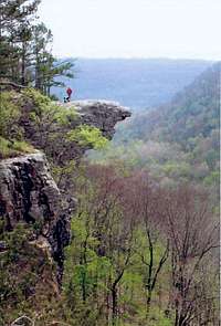
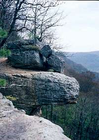
Hawksbill Crag
Hawksbill Crag - also known as Whitaker Point - is an Arkansas landmark that is widely seen in tourist publications & advertisements for the state. It is located on Cave Mountain within Ozark National Forest/Upper Buffalo Wilderness Area and just south of the boundaries of Buffalo National River area.

Cave Mtn Road
From I-40, exit 58, Clarksville; take Route 21 north. About 39 miles out, Route 21 veers left while Route 16 goes right. Continue on 21 for ten miles and cross the Buffalo River. Take the left turn immediately after crossing the bridge onto Cave Mountain Road. Coming from points north, this bridge is 1.2 miles south of Routes 74 & 21 junction.
The road goes uphill from here and gets rough and narrow at times You will pass a small church and cemetery on the right in about 5.5 miles. A half mile passed the church there will be a parking area on the right. The trailhead is across the road. There is a monument there honoring Senator Dale Bumpers.
Trail Route

Trailhead

Falls
Neighboring Crag
From the trailhead, the Crag is 1.5 miles one way and around a 200' decline in elevation. You will cross at least 4 creek beds on the trail to the crag. The first one is almost at the beginnning of the trail and shortly after this is the registration board. One mile in, you cross a fourth creek bed or creek depending on the season. Stay on the trail to the left for the more direct route to the crag. Continue on the trail and it will bring you along the bluffline. Soon enough you will see the crag's outcropping to your right. Or - take the right turn and follow the creek, it will bring you to the bluffline. Take a left and follow the trail which will bring you to the crag. Look around and you will find ways to step down and see the creek's waterfall there is another waterfall off the second bluffline as you continue on into the wilderness area. The valley is open to hiking though there are not many established trails down there.
Red Tape
BE CAREFUL ON THE CRAG!! If you walk out too far to get a better look and slip, it's a 150 foot fall!! People die from falls here - one as recent as April 2019.
On the trail, be sure not to go past red blazes as they're on private property - not part of the wilderness area.

Summer

Spring