
|
|
Canyon |
|---|---|
|
|
45.44450°N / 116.586°W |
|
|
Hiking, Mountaineering, Trad Climbing, Canyoneering |
|
|
Spring, Summer, Fall, Winter |
|
|
Overview

While the Grand Canyon has the distinction of being the longest and widest gorge in North America, Hells Canyon is the deepest. Unlike the Grand Canyon, which has a definitive rim, or “top”, Hells Canyon is gradually sloped and terraced. As such, the highest point of Hells Canyon cannot be seen from the lowest point.
Hells Canyon is located along the Snake River, on the border between northeastern Oregon and western Idaho. The canyon is approximately 72 miles long, 10 miles wide, and 8,000’ deep. Rich in scenery and history, Hells Canyon has much to offer any outdoor enthusiast.
History
Hells Canyon started forming approximately 6 million years ago when natural streams, which would eventually become the Snake River, began eroding away the volcanic rock of the landscape. With this erosion still occurring, the canyon is continually becoming deeper over time.
Approximately 15,000 years ago, Idaho’s Lake Bonneville had a spillover that resulted in a massive volume of water rushing through Hells Canyon. Although this event did not make the canyon deeper it did increase the overall width and shape of the rims, forming large flat terraces throughout the gorge.
 Ancient Pictographs
Native Americans were the first humans to settle in Hells Canyon. For many years the canyon provided a passageway and temporary home for the Nez Perce tribe, most notably, but also the Shoshone-Bannock, Northern Paiute, and Cayute tribes. Evidence of these original settlers is still found in Hells Canyon today, thanks to pictographs and petroglyphs left behind at various locations along the river and canyon walls. Originally used as markers for river crossings, settlements, and routes, today the pictographs and petroglyphs symbolize the long rich history of these original canyon visitors.
In 1806, several members of the Lewis & Clark Expedition briefly entered Hells Canyon but chose to turn back and head another direction. Then, in 1811, Wilson Price Hunt, following journals left by the Lewis & Clark Expedition, attempted leading the Astor Expedition into the canyon in hopes of finding the quickest route northward. The group was unsuccessful, forced to find other routes and travel methods after encountering harsh rapids that capsized their canoes and eliminated much of their food & supplies.
Miners became the next settlers in Hells Canyon, discovering gold along the riverbanks during the 1860s. However, the mining boom was shortlived and mostly unprofitable, causing the canyon to be deserted of most settlers again. Then, in the 1880s, farmers and ranchers began moving to the area but most only briefly stayed because of the unpredictable harsh weather and environment within the canyon area. Only a few ranches were able to persevere until today. Kirkwood Historical Ranch, an abandoned ranch which was once the home of former Idaho Governor Len Jordan, has been established as a major interpretitive location within Hells Canyon. Accessed only by boat or trail, the site contains 7100-year old archaeological evidence of early human settlement as well as a more recent homestead and ranch to explore.
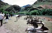 Kirkwood Historical Ranch
In 1975, Congress created the Hells Canyon National Recreation Area (HCNRA). The HCNRA is comprised of 652,488 acres within Oregon and Idaho, including nearly 215,000 acres established as a Wilderness Area (named “Hells Canyon Wilderness”) and three rivers (Snake, Imnaha, and Rapid) having sections designated as “Wild & Scenic”. No new roads, homesteads, or ranches will be built ever again in the HCNRA, although the few existing ranches at the time of the HCNRA designation were grandfathered-in and allowed continued operation. However, despite the establishment of the HCNRA, three hydroelectric dams are currently operational on the Snake River within Hells Canyon, each controversially lacking use of any fish ladders.
Recreation
Few roads exist in the HCNRA. However, over 900 trails are available for use by hikers, mountain bikers, and horseback riders. These trails can lead travelers to places such as Kirkwood Historical Ranch, Hat Point (the highest point on the Oregon rim of the canyon at 6,932’ elevation), He Devil / She Devil Peaks (the highest points on the Idaho rim of the canyon at over 9200’ elevations) and the other peaks of the Seven Devils Mountains. Hiking can be done year-round in Hells Canyon, but many visitors prefer hiking during late Spring-to-early Summer due to high rattlesnake activity in the area during mid-to-late Summer. Snake River Travelers
Other visitors might want to experience Hells Canyon the old-fashioned way: following the river. Local jet boat and rafting companies are available for travel on the Snake River, including the “Wild & Scenic” areas. Several of the river rapids can range as high as Class IV or V, making an unforgettable experience for any river adventurer.
Campers will take comfort in knowing there are dozens of campsites throughout Hells Canyon.
Fishing enthusiasts will take comfort in such knowing salmon, trout, sturgeon, and smallmouth bass can all be found in Hells Canyon.
Getting There

Starting from Lewiston, Idaho:
For access to the Oregon side (west rim) of Hells Canyon:
Follow Highway 12 West to Clarkston, WA. Then follow Highway 129 South to Highway 3 (entering Oregon). Then follow Highway 3 South.
The Wallowa Mountains Visitor Center is located in Enterprise, OR.
For access to the Idaho side (east rim) of Hells Canyon:
Follow Interstate-95 South.
A District Ranger Office is located in Riggins, ID.
For access to Hells Canyon Dam:
Follow Highway 86 North (in Oregon) to Snake River Road (in Idaho).
Follow Snake River Road North to Hells Canyon Dam.
External Links
Official Forest Service website for Hells Canyon.Hells Canyon Visitor Bureau (includes weather and recreational information).
Information regarding the Hells Canyon Scenic Byway.