

|
|
Mountain/Rock |
|---|---|
|
|
41.45765°N / 77.53211°W |
|
|
Lycoming county |
|
|
Hiking |
|
|
Spring, Summer, Fall, Winter |
|
|
2080 ft / 634 m |
|
|
Overview
Hemlock Mountain lies at mile 29.5 of the 42.4 mile Black Forest Trail in northern Pennsylvania.It has steep slopes, and the trail follows a stream up to the plateau, where a ridge is crossed to finally climb the last 300 feet to the top.
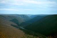
The View on top is a treat. When on top, one can look on either side of the mountain. When looking to the North, one will see the rolling mountains that border Pine Creek Gorge. When looking to the South, one will get a good view of the mountain Half Dome. To the East the mountain slops down steeply and its base is at Pine Creek almost 1,300 feet below the summit of the mountain.
 A fall view of Hemlock Mountain
Getting There
There are a few different routes to get on top. The main route is from the Black Forest Trail. Now there is a cut off trail from Forest Road/Big Trail Scenic Road which is recommended if you don’t want to hike the full 29.5 miles of the BFT (Black Forest Trail) to get to top. So if you just want a nice day hike to the top, you will want to park on Forest Road/Big Trail Scenic Road. It’s an old unmaintained road, so I would only suggest taking a vehicle fit for the task. Parking is also very limited. There is not a “parking area” but you are allowed to pull off to the side of the road and park there for day use only. Just find an area clear of brush where your vehicle will not interfere with other traffic. This road is rarely used. Normally it’s only used by seasonal hunters and hikers. To get to Forest Road/Big Trail Scenic Road you have two ways. Spring view from the summit, looking down Pine Creek
From the south:
If you’re heading north from where 664 and 44 merge and become PA- 44, you need to travel 12.2 miles. You will then need to turn right onto Trout Run Road. Once on Trout Run Road, you will travel 0.5 miles to a fork. Bear left and get on Forest Road/Big Trail Scenic Road. Once on the Forest Rd./Big Trail Scenic Rd. follow it for 0.2 miles. You will find an unblazed trail on the left that will take you to the Black Forest Trail. The un-blazed cut-off trail is 0.6 miles long, dropping you right off on the BFT. Once on the BFT, you hike 1.2 miles to the summit of Hemlock Mountain. The Blazes of the BFT are orange rectangles. This section of the BFT is very easy and has no serious hills at all. Just a gentle incline once you get near the summit.
From the North:
If your at the junction of PA- 44 and Ole Bull Rd. head East on PA – 44 for 12.6 miles. You will then turn left onto Trout Run Road. Once on Trout Run Road, you will travel 0.5 miles to a fork. Bear left and get on Forest Road/Big Trail Scenic Road. Once on the Forest Rd./Big Trail Scenic Rd. follow it for 0.2 miles. You will find an unblazed trail that will take you to the Black Forest Trail. The unblazed cut-off trail is 0.6 miles long, dropping you right onto the BFT. Once on the BFT, hike 1.2 miles to the summit of Hemlock Mountain. The Blazes of the BFT are orange rectangles. This section of the BFT is very easy and has no serious hills at all. Just a gentle incline once near the summit.
Parking
If you would rather not park on the Forest Road/Big Trail Scenic Road. There is a designated parking area right where you turn off of PA-44 onto Trout Run Road. It’s a pretty big parking area and is made for people to park there while on the BFT. You can park there overnight too. If you park here, you have to walk to the cut-off trail using the directions from above. From this parking area at the junction of PA-44 and Trout Run Rd. its exactly 0.8 miles to the cut-off trail leading you onto the BFT. You also have to walk along the road so be careful of traffic.The safety of your vehicle is average. When parking anywhere near the trail, it will be secluded and there’s not much of a human population around to intervene if a robbery were to occur. Park at your own risk always, expect the worst to happen so come prepared and properly equip your vehicle.
 Late fall view of Hemlock from the west
Camping
Hemlock Mountain is located on the Black Forest Trail, and camping is allowed anywhere along it. This is not needed though because there are so many designated camping areas already established along the trail. On the top of the mountain there is a very nice over look, there is a camp site there on top situated in such a way, that if you set up camp right, you can watch the sunrise from your tent come up and through the overlook area. It’s very beautiful, but make sure there’s good weather because it can get windy on top of the mountain.If you continue on the BFT which heads North, it will take you down the North side of the mountain. Its 1 mile to the bottom of the mountain, where you will find yourself in Naval Run valley. The stream flows down this valley, and there are three different designated camp sites along this creek.
 Early winter view from the top of Hemlock
The creek provides water but must be purified or treated before consumption.
Small Campfires are permitted most of the time, but they must be near water. From October 1st through May 25th however, is considered a period of high potential fire danger. In this case, one must obtain a camping permit. A camping permit allows you to have a campfire in-between those mouths of restriction. Campfires are also prohibited when there is a “high fire danger” posted. For camping permits and details on regulations of fires, contact this number. 570-327-3450. (This number will connect you to the Tiadaghton State Forest main office, their address is also listed under red tape.)
Hazards
When traveling to and from this area in the winter, remember snow and ice are very dangerous to travel in. Many of these roads are back roads and do not get much attention when it comes to being plowed properly or well salted and maintained. In particular, Road/Big Trail Scenic Road is not maintained at all during the winter, and is advised for no driving at all. Snow mobiles use this road in the winter, but other vehicles are strongly not recommended. Please use good judgment when traveling in hazardous conditions.Heavy rains can wash out roads and cause huge pot holes. Be careful when driving and avoid driving right after a heavy rain. On dirt roads, a heavy rain will wash away the surface covering of dirt on the top and reveal rocks that can be damaging.
Wildlife
The Wildlife in this area includes the normal arrangement of animals commonly found in this area. Deer, skunks, rabbits, squirrels, chipmunks, a wide verity of snakes, all kind of small mammals and rodents, plenty of insects and bugs to bother you in warm weather. The ones you should be mostly aware of are Bears, Porcupines, and Timber Rattle Snakes.Porcupines are not dangerous animals, but when tampered with can inflict pain through their quills. They are also very attracted to salt and will chew though break lines, cooling hoses, and fuel lines just to satisfy their craving. When you park, place some mouth ball under your vehicle to ward off these critters and your automobile should be safe. Just remember to clean up the mess when you’re ready to leave. Also, if you’re sleeping a night make sure your boots and socks are out of reach of scroungers as well.
 Summer view of Hemlock from Bob Weber Trail (Hemlock is the mountain on the right)
Bears are of no concern during the cold winter months because of their hibernation, but during the spring, summer and fall, black bears roam the woods. They are not a threat unless you antagonize their young and they feel a need to protect their cubs. Also, try to keep food tightly sealed and closed. If you encounter a bear, the best thing is to stay away and scare it away. Usually making a loud noise will do the job. Take photos, but use good judgment when dealing with these creatures, since they can be very unpredictable.
Timber Rattle Snakes are just crawling all over this area; they will usually give you a warning when you’re close. And you will hear their rattle. When you hear this, you need to quickly move or stay clear of the area from which the sound is coming. They will only strike normally when threatened and is on its last resort. Bites will only make one sick, and that’s never fun. Very rarely are bites fatal, but it has happened. You can avoid encounters by watching where you walk, and being aware of clear open rocks and sunning areas. These are prime locations for rattle snakes to sunbath and soak in the heat.
Maps/Guidebooks
There are no specific maps or guide books drawn up or written up for this mountain. But if you buy the Black Forest Trail book which includes a detailed topographical map. You will find the roads and cut-off trail quite easily. When looking at the map, look for mile 28 listed on the map that follows the BFT. This is the location of the cut-off trail used to access the mountain and is an easy reference point. More information on this map and guide book can be found here.http://www.spgear.org/gear/6120/black-forest-trail-map-guide.html
Red Tape
Camping at and around the mountain is allowed all year around. Fires are prohibited though through October 1st to May 25th. If you would like to have camp fires during that time, one must obtain a camping permit. Campfires are also not aloud when there is a high fire danger warning in the area. View from Hemlock
The Hemlock Mountain area is maintained by Tiadaghton State Forest, Bureau of Forestry, PA Department of Conservation and Natural Resources. It is also located in the Tiadaghton State Forest boundaries.
Any questions or requests can be answered through the Tiadaghton State Forest Offices. Here is their address and phone number:
Tiadaghton State Forest
423 E. Central Ave.
South Williamsport, PA 17702
(570) 327-3450
www.dcnr.state.pa.us/forestry/state forests/tiadaghton.aspx.