Stats/Intro
Conejos Peak- (13172')- CO Rank 505
Summit Peak- (13300')- CO Rank T392
Bennett Peak- (13203')- CO Rank 485
19.5 miles RT, 6500' gain
July 1, 2006
Southern San Juan Mountains
All Pics
These 3 13ers/county highpoints are relatively easy hikes over gentle terrain. All of them are accessible by trailheads of 11000' or higher and are fairly close to one another, which increases the odds of bagging all of them in a long day. I had read of Layne Bracy's successful trip exactly one year ago and figured I would give it a shot since these are so remote. This was the first time to try 3 seperate climbs in a day. This trip turned out to be a little more than I bargained for! The trailhead to the first peak of the day, Conejos, was around 5 hours from Colorado Springs
Conejos Peak
Conejos Peak
Conejos county, CO county highpoint
7 miles RT, 1700' gain
from Tobacco Lake TH (11560')
I drove in the night before and followed Mitchler and Covill's guidebook directions. The trailhead has been moved since their publication and FR-105 is marked incorrectly on the topo. The trailhead is now 7.5 miles from the Lake Fork Ranch turnoff. There is a side road to the left that you take for the last 1/3 mile and is signed.
I awoke at 4am in anticipation of a long day. Weather would likely be an issue on Bennett, so I started the short hike of Conejos at 4:30. The new trail is great and was relatively easy to follow by headlamp. I could hear elks bugling in the distance and their tracks were evident. I found the right turn at the broken post at the 1 mile mark and followed the gentle, traversing trail around Pt 12429 to beautiful Tobacco Lake.
![Tobacco Lake]() Beautiful Tobacco Lake on the way to Conejos Peak.
Beautiful Tobacco Lake on the way to Conejos Peak.
I then picked up another trail on the north side of the lake, which took me up to the ridge. It is broken in spots, but there are occassional cairns to lead the way. The goal is obvious. From the ridge, it's just a short, gentle stroll to the summit.
![Conejos Peak]() The gentle stroll to the summit of Conejos.
The gentle stroll to the summit of Conejos.
I arrived at 5:56am just after sunrise, the earliest I have been on a summit! I enjoyed the sunrise and gazed at my next two objectives, Summit and Bennett. There were quite a few people in the register for such an obscure peak. After a 17 minute break, I headed down the enjoyable trail to the car, seeing a couple elk along the way. I arrived back at the car at 7:17.
What Not to Do on Summit Peak
Summit Peak
Archuleta county, CO county highpoint
8.25 miles RT, 3500' gain (including routefinding errors)
From FR 243 (11000')
Summit is also supposed to be an easy climb other than the initial bushwacking, but I turned this into a mini-epic with two routefinding errors. Summit is also along the continental divide and is #29 on the CO prominence list. This peak is only 8 air miles from Conejos, but the driving through the maze of forest roads takes time.
The trailhead for Summit is at 11000' at the terminus of FR 243 west of Lake De Nolda. This would be the longest climb of the day, but should have been much shorter. I set out at 8:43am as the skies were still looking great. The route initially follows a faint trail along the northern side of Treasure Creek. The directions were to cross the creek at .3 miles just past the first of a series of waterfalls.
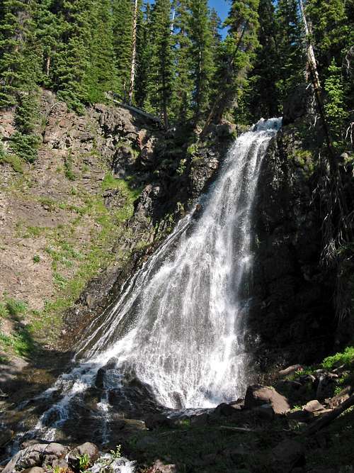
![Waterfall along Treasure Creek]() Spectacular waterfall along Treasure Creek on the way to Summit Peak.
Spectacular waterfall along Treasure Creek on the way to Summit Peak.
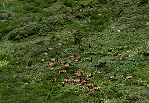
I think I crossed a little early, but it worked out. The route up the drainage was easy to follow as I just stayed on the south side of the creek. Once clearing treeline, there are some willow bashing to be done but I followed elk paths to avoid any major bashing. As I climbed further up the basin, a large group of 30-40 elk greeted me with their interesting communication. This is the largest herd I have seen in Colorado as they for the most part were not disturbed by my presence.
![Herd of Elk]() A large herd of elk greet me in the upper Treasure Creek basin.
A large herd of elk greet me in the upper Treasure Creek basin.<
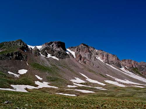
At around 11800', I headed south up a steep bench and gained the upper basin. Here you are greeted by the impressive north face of Summit, which looks like it would have some cool snow climbs. The dry winter in the San Juans was evident as the snow in the upper slopes was almost gone.
![Summit Peak north face]() The impressive north face of Summit Peak. Easier terrain is around the east ridge.
The impressive north face of Summit Peak. Easier terrain is around the east ridge.
At around 12500', I caught the Continental Divide trail which skirts around the east ridge of Summit so that you can climb its more gentle southeast slopes.
The major error that I made on this peak is I thought this trail took me all the way over the south ridge to the southwest side. It didn't! Thinking I was on the opposite side, I headed left to what I thought was the summit even though my GPS waypoint told me different. Occassionally I load them incorrectly. I soon noticed that the point to the right was much higher, so I just followed the spectacular contrasting south ridge to the summit. All of that confusion led me to believe I was on the north ridge, which came back to bite me on the descent.
I topped out at 10:48am and noticed that clouds were building early. A distant rumble of thunder persuaded me to keep my visit short and I left after 20 minutes. I descended the south ridge back to a saddle with the southern sub peak that I initially was headed for. On the way up, I noticed an attractive trail bailing down a steep scree gully that I thought would be a shortcut. I bailed off the ridge to the right (west) which was on the opposite side of where I wanted to be! I scree surfed down to 11400', paused, and wondered why the basin looked so different. I stared at my GPS coordinates in disbelief as I confirmed my place on the map.
There was no way I was going to reclimb the gully I descended, so I scanned the map for an escape route over the ridge. I decided to traverse to the north and look for a safe ascent route to a gentle saddle north of Summit. I thought this could take me several hours as the bushwacking was brutual as I traversed several drainages and huge debris left over from an avalanche. I ended up finding a reasonable, grassy gully which took me all the way to the saddle at 12460'.
I was thinking of salvaging the day by climbing nearby ranked 13er "Unicorn", but a close clap of thunder axed that thought. Dark clouds were now hovering overhead as it now became a race with the weather to treeline. I bombed down the slopes and the heavens quickly unleashed loads of hail. I made it back to treeline stopping to put shell and gloves on and was relieved to be out of this mess. I was back at the car at 2:45pm. Lesson learned: Pay attention to the map even though it's an easy climb!
The Finale-Bennett Peak
Bennett Peak
Rio Grande, CO county highpoint
4.25 miles RT, 1500' gain
From Blowout Pass (11780')
I was very uncertain that I would get a chance at Bennett now that a storm had blown in, but I thought the weather could move out by the time I got up there. By the time I started driving up the road to Blowout Pass, the rain had stopped. It looked like I could squeeze it in! The southern approach to Blowout Pass is a little sporty for my Hyundai Santa Fe, but it did well and I was at the pass just before 4pm. I would not want to drive that narrow shelf road when muddy!
![Bennett Peak]() View of the gentle slopes of Bennett Peak from Blowout Pass.
View of the gentle slopes of Bennett Peak from Blowout Pass.
At this point, I was running on fumes. This hike would be a cakewalk when fresh but it kicked my butt. This climb follows ATV trails all the way to the summit. It initially climbs to the saddle with 12er Sheep Mtn, then heads left to the gentle slopes of Bennett. At around 12700', I left the road and just headed directly up the slopes. Dark clouds were in the vicinity, but I didn't hear any thunder. The weather held and I summitted at 5:03pm. After a quick call to my wife and some snacks, I headed back down. Nearby 12er Sheep looked very close and inviting, but I had nothing left in the tank with a long drive home. The only people I came across along the trail on all 3 peaks were 2 ATV'ers on the descent of Bennett. I guess a lot of them drive to the top. I was back at the car at 6:02pm, happy to make it through the day!
Comments
No comments posted yet.