Desert delight
I know a heading like "Desert delight" is a little corny but this peak and trip rescued me from winter. I normally don't mind winter but this winter in Utah was surprisingly long. I had been living in the "high" desert of Washington State for most of my life and winters there are relatively mild
and often without much snow. After moving to Utah, I came to both enjoy and abhor an overabudance of the white stuff. I love snow in the mountains, I just don't like to have to shovel the stuff as much as I did this time around. It is not surprising then (at least to myself) to admit that I often began dreaming of being surrounded by cacti and warmth, both of which were south in the land of Arizona. I had been planning this trip to Arizona for a long time and finally, it was time to head south.
As my wife and I got up early on the morning of April 12th, we found our vehicle covered in yet another layering of snow. In fact, it was snowing
as we loaded the rest of our stuff into my Tacoma truck at 4 a.m. Good grief, even the lawn was covered in snow as the grip of winter was
lingering in this area of Utah. Time for some brown hills and that warmth I had been dreaming of. My wife was not going to accompany me past Las Vegas as she would catch a flight to Portland (Oregon) to spend time with the grandkids as I journeyed around Arizona chasing mountains that had special significance to me.
After leaving Las Vegas I checked my cell phone and found that I had a message from my friend
Rick Hartman who would be meeting me at the trailhead for my first objective, Harquahala Peak, the highpoint of La Paz county and a prominence peak. He would be there early to get set up for cooking his specialty, bbq chicken, a mouthwatering treat (as it turned out). He had left his home in Prescott and was most likely already at the trailhead as I crossed over the top of Hoover Dam, heading his way.
On the way down I enjoyed looking up at Mt. Wilson, Mt Tipton and Perkins Peak to name a few of the peaks I intend to visit on subsequent visits to Arizona. I eventually made my way to the spot on the highway 60 where a lone palm tree on the north side of the highway serves as a landmark for
where to turn off to approach the trailhead for Hq mtn, between mileposts 70 and 71. I crossed over to the south side of the highway and when I opened the door to go open the gate, I noted not only the mountain looming
above me but I noted the WARMTH. Yum. It was 82 degrees. (See Scott's description of the Trailhead area)
Rick and the amazing visitor
As I drove up to the end of the road, I could see Rick's red expedition already there and Rick gathering some firewood that would be utilized in the creation of his promised bbq chicken dinner. Did I mention that it would be accompanied by fresh asparagus? No, I didn't but I didn't want to get any reader of this report drooling in anticipation (as I was). Fresh asparagus ranks right up there as one of my favorite foods. I realized on the way that I had nothing to add to the dinner and chided myself for such an oversight. I hope Rick didn't notice that I came bearing no additions to the forthcoming meal. Arrrgggghhhh. (Don't tell my wife, she's taught me better).
I should mention that Harquahala Mountain has a road up to the summit on the other side (the south side) but
Bill Jacobs (
see picture) had mentioned that he would like to hike it via the trail and would like me to accompany him at some future time. That future time had now arrived but Bill, undergoing some surgery would not be able to join me. He mentioned to Rick that I intended to return to Arizona for an attempt to finish the Arizona county highpoints and Rick was kind enough to join me on this one as well as Wrightson and Browns. Rick's previous experience on Harquahala was the road and the thought of hiking the trail caught his fancy as well. Rick had already completed the Arizona county highpoints (as well as 49 of the USA state highpoints) so I felt very appreciative that he would ask. I had hiked with Rick on Arizona's Signal, Graham, and Gila county efforts and I looked forward to hiking with him again. I should mention that the USA State Highpointer meeting is being hosted in Arizona this coming September and Rick has been super busy putting that effort together.
After having some time to visit with Rick and get caught up on everything,
Rick mentioned that we might have another person join us for dinner. He wasn't sure if the guy would make it or not but he had received a call from a fellow state highpointer that he might visit us. Rick was hopeful he would and I would soon find out why.
When a rental car rumbled up to the trailhead, a huge grin split Rick's face and I was soon to find out why. Out stepped of the car, a man who had
completed all 48 of the continental USA state highpoints. What made this accomplishment so amazing is that this man lives in Holland. I had the pleasure of shaking the hand of
Sjaak Van Schie. Sjaak had just driven all the way from New Mexico just to have dinner with Rick in truly the middle of nowhere. He would be driving to Phoenix in the morning to catch a flight back to Holland. In talking with Sjaak, I found out that he has made over a 100 trips to the U.S. to do the state highpoints. He was actually working on his second time around, which to me was absolutely incredible. And talk about class, Sjaak had even brought a pie to add to our dinner. This guy drives all across New Mexico and brings something and I merely had driven from the middle of Utah and brought nothing. I felt a tad bit embarrassed (as I should have).
Rick fed us well and we had a delightful evening of visiting and sharing experiences. I must admit to trying to be the listener as both of these
guys had so many interesting stories to tell. Did I mention that the chicken melted in your mouth or that the fresh asparagus kicked major taste buds into happy orbit and that Sjaak's pie was the perfect topper? Oh yeah to all of those. Did I mention that there was ample food to go around but both Sjaak and I both eyed the last piece of chicken (which was Rick's) lustfully even though we had both just eaten two huge pieces already.
Rick had a tent for Sjaak to spend the night and after mentioning that coyotes and mountain lions loved people in tents, Rick and I retired to our respective vehicles where we safely spent the night. In the morning,
Sjaak was still in one piece and as Rick and I lifted our day packs for the hike, Sjaak drove his rental car on his way to the Phoenix airport, about three hours away.
The hike itself
![Map of the trail]() Map
Map
As you can tell, even before we set foot on the trail, this trip had been worth it. The trailhead area it self is one of the better BLM trailheads that I've ever visited. The toilet facility has a cement walk way leading to it and in the dark of night, that little luxury is appreciated. An information kiosk tells of the hike and a trail sign in register is located a short distance away. The hike itself is about 5.5 miles and you gain over 3400 in elevation to attain the summit. This is not a hike to be done in the heat of summer, I'm not sure you could carry enough water. The temperature at 6 a.m. when we started out was a cheerful 63 degrees, in my opinion, just about perfect.
![Trailhead information]() Trailhead info sign
Trailhead info sign
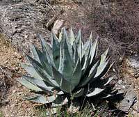
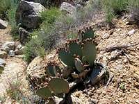
Sajauros were everywhere and Rick pointed out that they were one of the marked differences between the Mojave desert (California) and the Sonoran desert (Arizona). Sajauros didn't exist in the Mohave desert and that they were a Sonaran desert feature. As we made our way up the trail, passing the
old remains of the original base camp, I began to ask Rick a ton of questions about the flora that abounded in so many different varieties. I felt like I was walking in an arboreteum where all different species are placed for a visitor's viewing and educational enjoyment. I was to find out that there are lots of different cacti (you know, those plants with the pointy and ouchy things) and it was nice to have a "tour" guide, explaining
what this was and what that was.
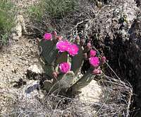
As we gained elevation, different species would appear and the colors of some of the plants were incredible hues of deep lucious reds, oranges, yellows, magentas, etc. We'd hike along a bit and wham, we'd be stopped dead in our tracks by a flower that had an even more amazing hue to it (or them). I found that my pictures didn't even come close to capturing what
the eye was beholding. I must bring my wife here so she can experience
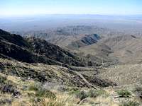
what I did. The trail passes some old mining efforts and in a couple places, strange wires,were to be seen (most likely for some type of antenna). The trail albeit rocky, is never a chore. It gains altitude at a steady grade and is a terrific footpath, all the way up. It switchbacks at the right places and views open up to the mountains across the way and
I never got bored. It was interesting to see how dense the sajuaros were on one hillside as compared to the other. Sajauros obviously attract birds
as it appeared many had holes in them created by our avian friends. Each sajuaro has its own personality and hiking alone at night without a headlamp would be a spooky experience indeed.
As we got probably 2/3rds of the way up, we passed the remains of an old cabin. An information plaque was there to explain a bit of its history and
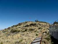
it is obvious that this unannounced trail has been well taken care of by the BLM folks. Soon the trail reached a ridgeline and for the first time you could see the summit structures and the 4WD road snaking its way up the other side of the mountain. The trail did a few more zig zags and soon it was traversing over towards the peak itself. A sign encouraging us to tie up our horses greeted us on the last stretch of trail and a windsock announced the highest part of the summit itself.
It had taken us just a bit under 3 hours to reach the top and there were information signs everywhere that explained the history of this unique
summit. Allow me to add that information at a later date but for now suffice it to say that the history of the top of this mountain is rather interesting and well documented by the information signs that are placed
in several locations.
The top
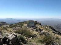
A windsock had been placed near the highest point and it was easy to find the benchmark and the exact highest spot, which I sat on to have my lunch and enjoy the view. Rick wandered around the top and was soon reading all of the information signs and absorbing the history of the place. Unfortunately a mild haze obscured the clarity hoped for but still, the views were impressive as mountains were visible in all directions. Would you believe that much of the haze is from Los Angeles far far to the west. Sometimes there is no escaping the pollution created by the large cities but a windy day would resolve that situation so it'd be a nice place to visit when the haze was removed via the wind. I-40 was visible to the south and I could see large trucks moving up and down the interstate.
![The windsock marks the top]()
To the north, I could see the peaks of two ranges I'd like to return to next time I'm in this area, Smith Peak and Harcuvar Peak. Both are prominencepeaks but I had no time on my schedule for those this time around. I rejoined Rick and as he ate his lunch, I had an additional snack and drank down more liquid as it would soon be time to head down. The temperature had risen steadily all day and it was nice to be going down as the heat was going up. The flower show continued on the way down and many of the flowers were now in full bloom. Rick generously let me lead the way down (rattlesnakes you know) and thanks to my quick pace, two hours down, we were soon back at the trailhead in 90 degree heat. Rick and I congratulated ourselves with a high five and all too soon it was time to leave Harquahala Mountain and this terrific trail behind as we were now ready to head south to Wrightson Mountain, south of Tucson for our next
days hike.
Time: 5 1/2 hours. 3 hours up, 1/2 hour on top and 2 hours down. Total distance 10.8 miles and 3400 feet elevation gain. I'd rate this hike
a 10 and one I will return and re-visit with Bill Jacobs. Heal up Bill,
this hike was your idea in the first place.
The flower show and trailside flora
![Beware]() Danger Danger
Danger Danger


Comments
Post a Comment