
-
 5500 Hits
-
 76.66% Score
-
 7 Votes
|
|
Route |
|---|---|
|
|
47.75410°N / 12.83804°E |
|
|
Hiking |
|
|
Spring, Summer, Fall |
|
|
A long day |
|
|
long hike with easy rock scramble |
|
|
I |
|
|
Overview
If you like traverses..... ,if you love the lower mountains in springtime with mixed snow and summer conditions..... ,
if you don´t mind to get tempted twice by mountain huts with nice terraces and Weißbier..... ,
if you like spring flowers, some rock scrambling, sometimes crowded summits and mostly lonely peaks and trails..... ,
if you want to check your stamina in spring time and your leg muscles for longer descents..... ,
if you like great views..... ,
and if you don´t mind ascending / descending about 1.800 meters of altitude difference and about 8 hours to hike..... ,
then I highly recommend the Hochstaufen – Zwiesel traverse.
Standing high above Bad Reichenhall and the northern alpine foreland, building a long east west running ridge, Hochstaufen and Zwiesel peaks are the northernmost mountains of Berchtesgaden Alps. As the alpine foreland and Bad Reichenhall are rather lowlands (Bad Reichenhall has an elevation of only 473 m) Hochstaufen and Zwiesel with both about 1760 m height are 1300 meters higher than the surroundings.
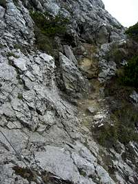
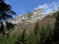 Hochstaufen as seen from below Steinerne Jäger Hochstaufen as seen from below Steinerne Jäger |  Loferer Steinberge as seen from Steinerne Jäger Loferer Steinberge as seen from Steinerne Jäger |  Iron ladden of Steinerne Jäger trail Iron ladden of Steinerne Jäger trail |
This “first step” of Berchtesgaden Alps offer great views to the about 1000 meters higher main Berchtesgaden peaks, like Watzmann, Hochkalter, Reiteralm, and so on.
Both, Hochstaufen and Zwiesel are nice mountains. Traversing both of them is a great thing. If you follow my recommendation you mainly use lonely trails with much variety and you can summit about five peaks. There is rock scrambling, many ups and downs to test your stamina, some bail out routes in case of bad weather and some very nice meadows for a break and / or a nap.
Getting There
 Zennokopf and Hochstaufen
Use highway A 8 from Munich or Austrian highway (toll road) A 1 to the exit Piding / Bad Reichenhall.
Follow the road number 20 to Bad Reichenhall. Leave the road to cross the river Saalach at the signposts to Schneizlreuth, Karlstein, Nonn.
Immediately after the bridge turn right at the traffic light and follow the road to Nonn. Where the road turns to western direction take the first road to the right (signposts to Padinger Alm).
The first trailhead, a small parking area in the woods, is at the right where the road ascends more steeply. This is in my opinion the best trailhead for the traverse because you will easily reach this parking place from the end point of the traverse, the Gasthaus List. Be there not later than 08.00 a.m. on sunny weekends.
If that parking place is complete follow the road to Padinger Alm. The Padinger Alm trailhead is at the parking area below Padinger Alm at the end of the road. From the end point of the traverse, Gasthof List, you will have a nice ascent of about 100 meters at the end of your long day. Enjoy !
Route Description
 Route Overview
Section I – Trailhead – Hochstaufen
At the parking area cross the road to Padinger Alm and ascend on the trail zigzagging up to Padinger Alm.
At Padinger Alm follow the forest road at the end of the huge parking area up the south slopes of Hochstaufen. At a trail junction follow the forest road and the signposts “Hochstaufen – Steinerne Jäger”. This is our route to Hochstaufen summit – it is a less crowded and more interesting route than the normal ascend from Padinger Alm.
At the end of the forest road follow a trail starting right ahead of you. That trail leads steep up the wooden south slopes to Buchmahd, a beautiful beech tree wood. To your left there is a little spring, the only one until you reach the beer spring at Reichenhaller Haus.
After a steep ascent in the woods the trail reaches the broad col of Steinerne Jäger and the east ridge of Hochstaufen. At the trail junction with the route from Piding the Steinerne Jäger trail starts. It overcomes steeply the wooden lower parts of the east ridge until it reaches a first “vista point” with excellent views to the Berchtesgaden main peaks in southern direction.
An iron ladder helps up to easier terrain. The route starts to traverse some rocky south slopes, drops down slightly and gains a notch at a southern subridge. Now the route has to cross two subsequent cirques; the red-white-red marks are leading steeply up, then the route traverses the first cirque, reaches another subridge and rises steeply again. There is rock scramble involved until you reach a second notch after a nice traverse on a rock ledge.
Now a better trail starts again leading up to the visible Reichenhaller Haus. From crowded Reichenhaller Haus follow the trail up to equally crowded Hochstaufen summit.
Allow about 3 hours for the ascent.
 Steinerne Jäger trail Steinerne Jäger trail |  Steinerne Jäger trail Steinerne Jäger trail |  Steinerne Jäger trail Steinerne Jäger trail |
Section II – Hochstaufen – Zwiesel
From Reichenhaller Haus follow the trail dropping down in the direction of Padinger Alm. After some switchbacks this trail traverses the south slopes shortly below the connecting ridge Hochstaufen – Zwiesel and reaches a notch in the ridge. There is a trail junction: to your left the trail descends to Padinger Alm – a quick bailout route if the weather is getting bad.
To follow the traverse route turn right and ascend immediately to Mittelstaufen, a subsummit in the connecting ridge Hochstaufen – Zwiesel. Now you leave the crowded part of the traverse and you will be back in solitude and mountain wilderness. The beginning of the rock scrambling is secured with some steel ropes and soon you are standing at the broad summit meadow of Mittelstaufen. There is a summit cross and often some paragliders waiting for good thermal winds.
The route follows the ups and downs of the connecting ridge, winding through dense dwarf pines, scrambling up and down rocky heads, sometimes secured with steel ropes, passing little rock canyons and climbing down a steep chimney, in spring often filled up with snow.
After a prominent rise in the ridge the route drops down steeply first through dwarf pines and then down slippery rock slabs, secured again with steel ropes. After that the route levels more and follows the ridge to some wild spires and rock towers.
Instead of traversing these rock features the trail drops down again steeply on the south side to a rock notch below the wildest of those spires.
At the notch another steep ascent starts up to another prominent rise in the connecting ridge. The trail then traverses into another cirque full of scree. There is an offtrail bailout possibility in case of thunderstorms down to a traverse trail Padinger Alm – Zwiesel Alm (220 meters offtrail altitude difference).
At the other end of that cirque there is another steep ascent secured with some ropes followed by some steep scree and rock scramble up to a sort of notch.
At that notch the eastern summit of Zwiesel, Zennokopf, is visible. The route ascends more moderate, bears right and, arriving at the ridge crest, left again to aim now directly at Zennokopf. There is another steep zigzag part up to the summit cross of Zennokopf with marvellous views back to Hochstaufen and the rugged and rocky connecting ridge to Zwiesel.
At Zennokopf the surrounding landscape changes dramatically: there are moderate meadow and dwarf pine slopes building up the broad summit ridge of Zwiesel.
The traverse is about 2,5 hours.
 Steinerne Jäger trail Steinerne Jäger trail |  Mittelstaufen as seen from Hochstaufen Mittelstaufen as seen from Hochstaufen |  South slope trail below Hochstaufen South slope trail below Hochstaufen |
Section III - Zwiesel and the descent
After a well deserved break you have several possibilities:
From Zwieselalm follow the trail down to the forest roads (it is called “Maultierweg”, mules trail, due to mules doing the provision of that hut). Arriving at the forest road follow the signposts “Listsee”. You immediately leave that forest road to the left.
Descend that old forest road you are following now down to another crossroad with a forest road. There is another old forest road leading you down to a power line – again follow “Listsee” signposts.
After crossing that power line a trail branches off to the left following the power line down to Listsee and – on another forest road – to Gasthof List at the end of the road leading up from Bad Reichenhall to Nonn.
Follow that road until you reach the road leading up to Padinger Alm. There you are back at your car.
If you have your car parked at Padinger Alm leave the Nonn road at the first houses after Gasthof List to the left. There is a forest road (signposts) leading up to the parking area of Padinger Alm.
 Trail junction below Mittelstaufen Trail junction below Mittelstaufen |  Mittelstaufen Mittelstaufen |  Little canyon to cross Little canyon to cross |
Essential Gear
The Hochstaufen – Zwiesel traverse is a spring, summer and autumn hike.The routes can be mainly snow free early in spring, it is normally open in april / may until the first heavy snowfalls.
The route requires full hiking gear, good shoes and some rock scrambling experiences (UIAA grade I, mainly secured with fixed ropes). In my opinion you don´t need via ferrata gear.
 Rock scramble Rock scramble |  View from Mittelstaufen to Zennokopf View from Mittelstaufen to Zennokopf | 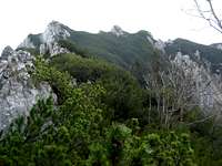 Mittelstaufen Mittelstaufen |
Check the weather forecast here.
The following maps can be recommended:
Alpenvereinskarte Bayerische Alpen
Scale 1 : 25.000
Number BY 19, Chiemgauer Alpen Ost, Sonntagshorn
Kompass Wanderkarte
Scale 1 : 50.000
Number WK 14 Berchtesgadener Land-Chiemgauer Alpen ISBN: 3-85491-017-7
Accommodation
All types of accommodation can be found at Zennokopf ascent Zennokopf ascent |  Rock spire notch Rock spire notch |  Scree cirque below Zennokopf Scree cirque below Zennokopf |
 Zwieselalm
Mountain huts and inns