Halo Ridge - Solo
Two years ago my friend Jake and I completed a two night backpack trip through Cirque of the Towers in the Wind River Range of Wyoming with a clockwise loop beginning and ending at the Big Sandy trailhead. Upon returning to Colorado my wife Julie and I had planned a two night backpack trip to Lake Constantine in the Holy Cross Wilderness as the second part of my week off. Jake had been wanting to climb a fourteener for some time and asked if he could tag along to the lake and then continue on to Mt. of the Holy Cross. He spent night one at upper Tuhare Lake and night two near East Creek and met us back at the trailhead on day three.
While at Lake Constantine Julie and I day hiked up to lower and upper Tuhare Lakes and we loved the place – particularly the waterfalls. After seeing Jake’s pictures from up around PT 13,831 I made it a goal to complete the Halo Ridge route loop up and over Mt. of the Holy Cross. The next summer our second son Logan was born so my time out was limited. This summer with the kids a little older I managed to take work off on Friday, July 16 because the weather was for high pressure throughout Colorado and blue bird skies for the whole day – just the kind of day to attempt Halo Ridge.
I wanted to reach the Notch Mountain Shelter not long after sunrise to see the famous Cross Couloir with ideal lighting. I was comfortable doing this approach solo in the dark as I had hiked the first few miles two years earlier on the Lake Constantine trip and had passed the trail junction up to the shelter.
On Thursday night we tucked both boys into bed and I headed out at about 8:30pm and made the drive to the trailhead in around 3.5 hours – give or take. I crawled in back of the vehicle and got a few hours rest and awoke, slowly, around 2:30pm. I hit the trail around 3:00am and was very excited to see what the day would bring.
Both the trail junction and tree line came and went pretty quickly. Once above tree line the stars were on full display and it was one of the better sky gazing nights I’ve had in Colorado. After a while the glow of sunrise began over the Gore Range with actual sunrise coming less than a half hour from me reaching the shelter. My anticipation built as I neared the ridgetop and finally the shelter was there in front of me. The next three photos are my attempt to capture those first few moments up there:
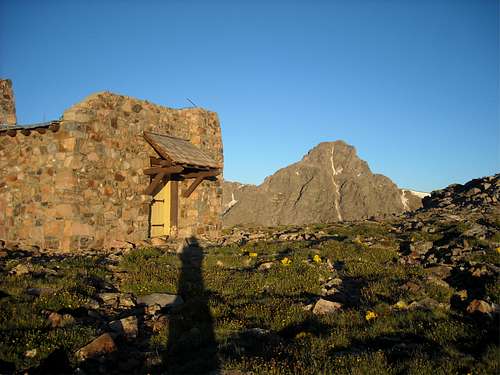
![Notch Mountain Shelter]() It was great to see the Notch Mountain Shelter in person rather than in photos or in my thoughts.
It was great to see the Notch Mountain Shelter in person rather than in photos or in my thoughts.![Mt. Massive from the shelter]() I was impressed to see such a clear view south to Mt. Massive from the ridgetop.
I was impressed to see such a clear view south to Mt. Massive from the ridgetop.![Notch Mountain Shelter]() As I approached the shelter the view of Mt. of the Holy Cross lived up to my expectation and then some. You just can’t put what I saw into pictures or into such a small frame like a camera lens and get the full wow effect
As I approached the shelter the view of Mt. of the Holy Cross lived up to my expectation and then some. You just can’t put what I saw into pictures or into such a small frame like a camera lens and get the full wow effect
After a few minutes of soaking in the views I checked the shelter to see if the reports that it was closed were true – it was closed. I found out later than it was repaired a few weeks later and is now open again. I quickly remembered that if I wanted to complete the Halo Ridge that my day had just begun even though I had already traveled over five miles and climbed about half a mile. I started out towards my first ranked peak of the day, PT 13,248. The route was fairly straight forward and the weather was amazing.
![Ranked 13,248 on Halo Ridge]() Heading south from the Notch Mountain Shelter was simply amazing. The route to PT 13,248 on the left was my second goal for the day.
Heading south from the Notch Mountain Shelter was simply amazing. The route to PT 13,248 on the left was my second goal for the day.
The route to PT 13,248 started out mostly grassy intermixed with boulders but closer to the summit it became mostly boulder hopping and would be a brief introduction to what would follow. Upon reaching the summit of PT 13,248 I decide to take another short break and briefly enjoy my second ranked Holy Cross Wilderness summit. My first was 13er Savage Peak in 2005 on a day hike to Missouri Lakes with my wife Julie – one of her favorite areas. I took this photo back towards the shelter from the summit:
![PT 13,248 Summit]() Notch Mountain Shelter with the Gore Range as an amazing background from the summit of PT 13,248.
Notch Mountain Shelter with the Gore Range as an amazing background from the summit of PT 13,248.
As I descended PT 13,248 I had a feeling that the route over to PT 13,373 would be the crux of the route and my opinion to this day is that it was. The initial south slopes of PT 13,248 were actually quite pleasant but closer to the saddle below 13,000’ were some obvious difficulties along the ridge proper that I found easier to skirt around on the east (left) which meant losing a little extra elevation. The climb back up to PT 13,373 was pretty steep and all boulder hopping. I have gotten much better at this kind of travel over the years and can say that it is quite comfortable for me now. It can get a bit tedious having to make every step the right way to avoid a sprained ankle or worse – particularly when going solo on a lightly traveled route. There is an old saying that you can’t tell how steep something is until you rub noses with it and I can say this slope looked worse than it was – but I still feel it was the crux of the Halo Ridge. These photos were taken along the route between PT 13,248 and PT 13,373:
![Crux of Halo Ridge]() Nice view of PT 13,373 on the left and PT 13,831 on the right. PT 13,768 along the southern Holy Cross Ridge pokes up just to the right of PT 13,373.
Nice view of PT 13,373 on the left and PT 13,831 on the right. PT 13,768 along the southern Holy Cross Ridge pokes up just to the right of PT 13,373.![PT 13,831 & Holy Cross]() View of Centennial Peak 13,831 and Mt. of the Holy Cross from near the saddle between PT 13,248 and PT 13,373. Notice my shadow in the lower left – cool.
View of Centennial Peak 13,831 and Mt. of the Holy Cross from near the saddle between PT 13,248 and PT 13,373. Notice my shadow in the lower left – cool.![13,248/13,373 saddle area]() This was taken on the climb up PT 13,373 looking back at PT 13,248. It shows some of the elevation I chose to lose to avoid the difficulties along the ridge proper. I think the most difficult or most frustrating portion was losing elevation to go under the large gash below the snow patches in the upper right.
This was taken on the climb up PT 13,373 looking back at PT 13,248. It shows some of the elevation I chose to lose to avoid the difficulties along the ridge proper. I think the most difficult or most frustrating portion was losing elevation to go under the large gash below the snow patches in the upper right.![Tuhare Lakes]() On the climb up PT 13,373 I took this photo of lower and upper Tuhare Lakes with ranked Whitney Peak (13,271) in the upper left and Fall Creek Pass just out of view at the bottom right of Whitney Peak. The nice water fall between the two lakes was one of Julie and my favorite spots on our backpack trip two years earlier.
On the climb up PT 13,373 I took this photo of lower and upper Tuhare Lakes with ranked Whitney Peak (13,271) in the upper left and Fall Creek Pass just out of view at the bottom right of Whitney Peak. The nice water fall between the two lakes was one of Julie and my favorite spots on our backpack trip two years earlier.
I was very pleased to reach the summit of PT 13,373 and be past what I felt was the crux. It was a lot or work for an unranked peak but it is basically a false summit on the climb up PT 13,831. I took the next photo back at the ridge I had completed:
![PT 13,373 summit]() Looking back at the shelter and PT 13,248 from the summit of PT 13,373. The large drop between the summit and the saddle is apparent but looks worse than it is.
Looking back at the shelter and PT 13,248 from the summit of PT 13,373. The large drop between the summit and the saddle is apparent but looks worse than it is.
I was very pleased to see what way lay beyond PT 13,373. I knew from my maps and research that the going would be much easier for awhile but seeing it in person was just what my motivation needed. The large grassy plateau was almost like taking a break while continuing to move. The next several photos were taken on the route between PT 13,373 and my third goal for the day PT 13,831:
![Grassy Slope - A Nice Break]() This view was a sight to behold and just what I needed – a break from boulder hopping. My third goal for the day, PT 13,831, rises in the distance.
This view was a sight to behold and just what I needed – a break from boulder hopping. My third goal for the day, PT 13,831, rises in the distance.![Bi- Centennial PT 13,768]() Bi-Centennial Peak PT 13,768 rises dramatically above upper Tuhare Lake.
Bi-Centennial Peak PT 13,768 rises dramatically above upper Tuhare Lake.![Holy Cross above the Bowl of Tears]() The over 2,000’ drop from Mt. of the Holy Cross down to the Bowl of Tears is quite dramatic as well.
The over 2,000’ drop from Mt. of the Holy Cross down to the Bowl of Tears is quite dramatic as well.![Catwalk on the Ridge]() One of the catwalk like areas that gives access to the much awaited grassy plateau.
One of the catwalk like areas that gives access to the much awaited grassy plateau.![Grassy Slopes]() Was this ever nice! I chose to head straight for the summit rather than stick to the ridge proper on the right.
Was this ever nice! I chose to head straight for the summit rather than stick to the ridge proper on the right.![Bowl of Tears Precipice]() I walked over to the north edge of the grassy plateau and peered down into the Bowl of Tears. The shelter rises over a thousand feet above on the right with the Gore Range as an amazing background. I wouldn’t have felt comfortable standing here with any wind.
I walked over to the north edge of the grassy plateau and peered down into the Bowl of Tears. The shelter rises over a thousand feet above on the right with the Gore Range as an amazing background. I wouldn’t have felt comfortable standing here with any wind.![Sweet Vistas]() PT 13,768 on the left with lots of Holy Cross and Elk Range peaks in the distance. Click on the photo for further peak identification.
PT 13,768 on the left with lots of Holy Cross and Elk Range peaks in the distance. Click on the photo for further peak identification.![Slopes of PT 13,831]() This was the general slope and boulder hopping from the grassy plateau up to the summit of PT 13,831.
This was the general slope and boulder hopping from the grassy plateau up to the summit of PT 13,831.
I was very excited to reach the summit of PT 13,831. It was my first Centennial Peak of the day and I figured it was now easier to climb over Mt. of the Holy Cross then retrace my steps back to the trailhead. Once at the grassy plateau I was following the route my friend Jake had taken two years earlier and he assured me that the rest of the route would be fine which was comforting. The following photo was taken from the summit of PT 13,831 back down the Halo Ridge:
![PT 13,831 Summit]() From left to right – PT 13,248, PT 13,373, and the grassy plateau. The two catwalk areas can be seen between PT 13,373 and the grassy tundra – particular by zooming in.
From left to right – PT 13,248, PT 13,373, and the grassy plateau. The two catwalk areas can be seen between PT 13,373 and the grassy tundra – particular by zooming in.
The following two photos were taken between PT 13,831 and Mt. of the Holy Cross and show the route remains Class 2:
![Mt. of the Holy Cross]() Mt. of the Holy Cross on the descent of PT 13,831.
Mt. of the Holy Cross on the descent of PT 13,831.![PT 13,831 from the North]() Looking back at PT 13,831 on the climb up the south slopes of Mt. of the Holy Cross.
Looking back at PT 13,831 on the climb up the south slopes of Mt. of the Holy Cross.
The final photo is me on the summit of my fourth goal for the day, Mt. of the Holy Cross, taken by a couple I met on top. There were a handful of others on the summit as well. They were the first people I saw for the day.
![Me on the Holy Cross Summit]() Me on the summit of Mt. of the Holy Cross.
Me on the summit of Mt. of the Holy Cross.
I chose to descend the standard north ridge route which was a trek all by itself. I didn’t include any pictures because it is the standard route and is well documented. I ran out of water and used a Aquamira tablet to treat water from East Creek and was on my way back to the trailhead and my fifth and final goal of the day, to return safely to my family. What a beautiful day for a beautiful loop hike!
Comments
No comments posted yet.