The Saga Begins
As the morning sun broke over the steep hills lining the Elwha River valley, the river itself babbled incessantly over the smooth stones in its way en route to the ocean. My wife Rachael and I were still asleep in our tent, trying our best to stave off the effects of a wee bit too much tequila the night before.
Today was the fourth day of our Olympic odyssey honeymoon, which had commenced in Seattle on Sunday, already brought us out to the beautiful Olympic Coast earlier in the week and would finish with a few mountain hikes. The night before we had decided that today we would hike Hurricane Hill from the Elwha river trailhead, nearby Altair campground, where we were staying. We were aware that it was of decent length [12.2 miles roundtrip] and knew that it gained a good deal of elevation on the way to the top, but we were both in very good shape and did not doubt we could climb it.
What we weren’t exactly aware of was precisely how much elevation it did indeed gain.
One mile.
But wait, that isn’t too bad, right? Five thousand two-hundred and eighty feet. Olympians can run that in under 4 minutes. But that’s horizontally. Mountaineers commonly gain and lose that much elevation in one day or less. But they’re pros. We, however, were not experienced mountaineers [though we aspire to be]; we were flatlanders from the Midwest itching to get out west, neither of whom had climbed a true peak in a few years. But we were sure we could do it.
So on that clear, crisp morning we rose from our sleep, shook out the tequila cobwebs as best we could and broke camp, driving the mile or so from the campground to the trailhead. We made sure we had plenty of Nature Valley bars and even some dried mango slices and figured on 3 liters of water being enough; 1 each on the way up and 1 to share on the way down. And at precisely 8:30, we took our first steps up the trail.
Up, Up, Up, Up and Away!
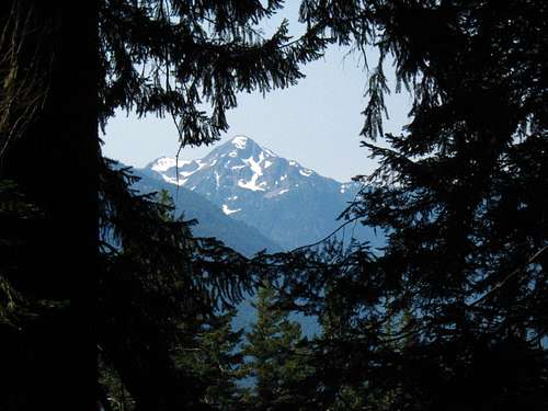
The trail began in the shaded cool woods on the east side of the valley, and wasted no time gaining elevation. Up, up, up we climbed through the ferns and moss, the whole time shaded from any hope of sun by massive pine trees. The trail consisted entirely of switchbacks. Yes, entirely. I know what you’re thinking “There must have been some downhills or at least level portions” I am here to tell you that there were absolutely no downhills and any level portion was too small to count. The trail got off with a bang, to say the least. There were a few nice little waterfalls that were next to the trail on the way up, but for the most part it was ferns, moss, trail, hill, hill. That Hill. That blasted hill ate away slowly at our legs for the next two hours as we climbed 4 miles up and up and up through the trees, sometimes having to stop every 10 minutes to slug some water and down a granola bar, to where the trail finally broke through into the light of a beautiful mountain meadow. In four miles of forested hillside, we glimpsed a snowcapped peak once.
![olympic range]() The one glimpse of snow we caught for the first four miles.
The one glimpse of snow we caught for the first four miles.
Now this whole time, we were giving a valiant effort in trying to reach the top. Rachael, God bless her, was probably a little bit less than happy that I had dragged her on this hike in the first place just because I thought it “would be cool.” I admit I neglected to tell her until we reached the top that we could have simply driven all the way out to Hurricane Ridge and hiked a mile up the paved trail to the top, but where would the fun be in that?
On to the trail.
Mountains, At Long Last
Once we broke the treeline, all suffering came to an end. For me anyway, and only temporarily. We now had an unhampered view of the Olympics from the north. Wow. What a view. Words cannot express the feelings that mountains stir within me, though I am sure that if you are reading this you, too, have had the same feelings.
![olympic range]() Breaking the treeline at last!
Breaking the treeline at last!![olympic range]() The first view we had of the Olympics.
The first view we had of the Olympics.
At this point we were two-thirds of the way to the top of our objective, and things were looking good. Nevertheless, there were still 2 miles to the top and we were not sure which of the peaks along the ridge we were on was Hurricane Hill.
![olympic range]() Looking towards Hurricane Hill soon after breaking through the trees.
Looking towards Hurricane Hill soon after breaking through the trees.
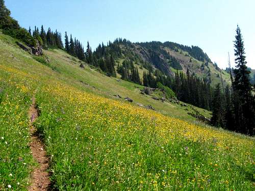
The next 2 miles were a bit more level than the first 4, but still mostly uphill. What made these far more bearable was the views to the south, and sometimes north. The trail kept switchbacking up and up through meadows until it was near the top of the ridge. Then it just climbed at an angle along with the ridge. The whole time we crossed wide open grassy meadows and went through small stands of knotted pine, the whole way littered with wildflowers of every imagining.
![olympic range]() One of many amphitheater-like meadows we crossed.
One of many amphitheater-like meadows we crossed.![olympic range]() Some of the many wildflowers near the top.
Some of the many wildflowers near the top.![olympic range]() Some more of the many wildflowers near the top.
Some more of the many wildflowers near the top.![olympic range]() Still more of the many wildflowers near the top. (Yeah, they were amazing enough to inspire me to add three photos in a row)
Still more of the many wildflowers near the top. (Yeah, they were amazing enough to inspire me to add three photos in a row)
These last two miles mostly consisted of the two of us gawking at the views and occasional breaks to catch our breath and soak it in. And of me telling Rachael that yes, the next hill probably was the top [though in reality my guess was as good as hers]. At long last, after 3 hours of climbing hill after hill, we glimpsed what we knew had to be the top. Unfortunately, our dead giveaway was not the fact that it was the highest peak on the ridge, but the fact that we saw a paved trail join our own and end a short distance later.
![olympic range]() View of the summit soon after we realized that this was (finally) it.
View of the summit soon after we realized that this was (finally) it.
And thus it came to be that we crossed the final stretches of alpine tundra and joined the elderly and overweight tourists on their quest for the fabled summit of Hurricane Hill.
![olympic range]() Wide open alpine meadow near the top.
Wide open alpine meadow near the top.Success
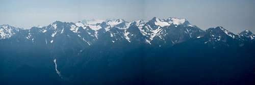
Actually, it wasn’t too bad. After 3.5 hours and 6.1 miles straight uphill, we had the summit to ourselves for the twenty minutes we stayed up there. We could see Port Angeles and the Ediz hook, and Vancouver Island, to the north and a sea of snowcapped peaks spread out before us to the south. And beautiful sunny blue sky encompassing it all. Wow. It was a beautiful day, even if it had caused us quite a bit of pain thus far.
![olympic range]() Summit panorama looking east.
Summit panorama looking east.
After snarfing down half of our dried mangos and a pack of stale saltines, we decided that we should share the summit with someone else. Oh yeah, and we realized that we didn’t have enough water. We had broken into our third liter early, to motivate us to reach the top in more heroic fashion, and now we knew we would run out on the way down.
![olympic range]() This is a pretty characteristic shot of the trail once you get above the forest.
This is a pretty characteristic shot of the trail once you get above the forest.Heading Down and Heading Home
So, we started back down the trail in the opposite direction we came up. It almost seemed improper to head downhill, losing all of that valuable elevation our quadriceps had worked so hard for. However, the ease of downhill walking soon boosted our morale and, combined with the stellar views, made the 2 miles back down the ridge top a breeze.
![olympic range]() Taking a quick breather on the way down.
Taking a quick breather on the way down.
One event worth noting: About a mile and a half down from the top we came across the only other person we saw on this trail that day. He appeared to be about 50 and was overweight, shirtless, wearing a sweat-stained baseball cap and carrying a canvas and leather backpack. However, he was one happy-looking dude. He politely asked how much further, and mentioned he was out enjoying nature to "get some fitness." We told him he was almost there, and he continued up huffing and puffing but with a smile. If, Mr. Shirtless, you are reading this: I hope you made it down safely and I am proud of you. Most people of your size/stature would not dare attempt that trail. Kudos.
![olympic range]()
From there it was a knee-and-hip-pounding 4 miles down to the parking area where we left our car, which we reached around 2:30. six hours for a 12.2 mile hike with one mile of elevation gained and lost; not too bad [says the flatlander]. The water lasted until all but the final 2 miles of the trail, so by rationing well we ended up not suffering too much [though we easily could have consumed a full liter or more extra]. We hopped into the car and found the nearest water supply and after filling our bottles back up, ate an absolutely delicious meal of rice and beans down by the Elwha River. From there we drove to our Bed and Breakfast in Port Angeles, where we knew we would get a good night’s rest after this day’s totally badass hike.
Epilogue
Is this story long enough for an epilogue? Sure it is.
Now that it has been done and said, I wish to make a quick statement:
Though it is not the highest peak in the Olympics, and it can actually be climbed by just about anyone if they want to, Hurricane Hill was a special mountain to us that day. It does not compare to the Denalis and K2s of the world, but on that Thursday it was, for us, the peak of our desire. There was only a little snow [one 6x6 patch off the trail near the top] and there were plenty of people once we neared the top, but that day, it might as well have been Denali to us because it provided us with a wonderful, adventurous tale to tell and plenty of memories to last a lifetime. Thanks for taking the time to hear about it.
Happy climbing,
Dan


Comments
Post a Comment