
|
|
Hut/Campground |
|---|---|
|
|
42.41000°N / 19.38000°E |
|
|
5863 ft / 1787 m |
Overview
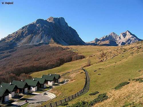
 The complex of "Eko Katun" Stavna
Belowe the peaks of KOMOVI range, on the Stavna vasty plateau, "Eko katun" Stavna (Ecological complex of renting houses) is situated. There are placed 10 houses for renting. Daily price for renting of one house is 25 Euro/5 Euro per person (each house has 5 beds and a new bathroom with warm water). Also, inside of Eko katun you can use the services of restaurant. Also, around the massif of Komovi you can find many beautifully places for your private camping in your tent.
"Eko Katun" Stavna is perfect starting point for hiking/climbing routes inside of KOMOVI range, specially for climbing of Kom Kucki (2487 m), Kom Ljevorijecki/Stari Vrh (2483 m), Srednji Vrh, Kom Vasojevicki (2461 m), Rogamski Vrh (2303 m), Bavan (2252 m) and Stavna (1828 m).
 "Eko Katun" Stavna
Getting There
 Ground flour
 Dinning hall
  Restaurant
By plane:
-To airport in Podgorica (Montenegro), closer airport to Komovi mountain.
-To airport in Belgrade (Serbia),...than from Belgrade you can use flight to Podgorica airport or go from Belgrad to Komovi by bus, by train or by car.
By train:
- From Belgrade (Serbia) to Kolashin, then with local bus till Mateshevo town, from where you can come to Komovi with these roads: - Matesevo-Andrijevica-Dulipolje-Cvrljak
- Matesevo-Jabuka-Uvach-Verusa
- From Podgorica to Kolasin, then with local bus or car to Komovi with same roads (above)...
By bus:
- Belgrade-Kolasin, then by car or local bus to Komovi (like above)...
- Podgorica-Kolasin, then by car or local bus to Komovi (like above)...
By car:
- Belgrade-Novi Pazar-Berane-Andrijevica-Tresnjevik pass-Stavna plateau
- Belgrade-Zlatibor-Bijelo Polje-Kolasin-Matesevo-Andrijevica (or Verusa)-Komovi
- Podgorica-Kolasin-Matesevo-Andrijevica-Tresnjevik pass-Stavna plateau
(Kolasin-Tresnjevik: 28 km by asphalt road; Tresnjevik-Stavna: 6 km by macadam road)
- Podgorica-Kolasin-Verusa-Opasanica village-Carine katun (Opasanica-Carine: 20 km by bad macadam road; Kolasin-Verusa road)
- Podgorica-Kolasin-Matesevo-Kraljske Bare (Matesevo-Tresnjevik road)-Ljuban plateau
Routes
KOM KUCKI (2487 m)Route 1: Stavna plateau (1787 m) - Ljubastica (1569 m)(T1) 45 min - Ljuban (1812 m)(T2) 45 min - Celo Medjukomlja (1860 m)(T2) 30 min - Medjukomlje Pass (2171 m)(T3) 2h - Kom Kucki (2487 m)(T4+T5) 1.30h
Route 2: Carine (1820 m) - Medjukomlje Pass (2171 m)(T3) 1h - Kom Kucki (2487 m)(T4+T5) 1.30h
KOM VASOJEVICKI (2461 m)
Stavna Eko Katun - Stavna Celo (1810 m) - Vera Pass (2200 m) - Kom Vasojevicki summit (2460 m)(T3): 2.30h
KOM LJEVORIJECKI (2469 m)
Stavna Plateau (1787 m) - Ljubastica (1569 m)(T1) 45 min - Ljuban (1812 m)(T2) 45 min - Iglenovo Polje (1980 m)(T2) 1h - Kom Ljevorijecki (north peak of Kom Kucki (2469 m)(T3) 1.30h
STAVNA (1828 m)
Stavna plateau (1787 m) - Stavna (1828 m) summit: 20 minutes
Maps
BJELASICA & KOMOVIMountain - touristic map
Scale 1 - 1:60000
Geokarta d.o.o Beograd, 2002
(Geokarta Ltd, Belgrade, 2002)