Account of Events
Prelude: The weather channel forecasted gusty morning winds, which has been a major concern as we were standing on the Icehouse Canyon trailhead (~4,950’) at 8 am on a chilly October day. Our group consisting of ten fairly experienced hikers all of whom I regard as in very good shape has planned to hike up
Falling Rock Canyon to the summit of
Sugarloaf Peak in the Mount Baldy area of the San Gabriel Mountains. After hiking the 3 T’s, Waterman and Twin Peaks, Iron Mountain, and Mount Baldy from the Village in the past few weeks, we decided to spice it up a bit and add some cross country and rock climbing to the menu. Various trip reports and route descriptions promised Falling Rock Canyon to be a perfect entree. We were however well aware of the common advise to not climb Falling Rock Canyon with too many people or at gusty wind conditions. It’s named “Falling Rock Canyon” for a reason, which we were to experience firsthand very soon. The original plan was to continue from Sugarloaf Peak on the ridge directly to
Ontario Peak and then return via the regular Ontario Peak trail to Icehouse Saddle and down the Canyon to the trailhead. Bagging
Bighorn Peak and possibly Cucamonga Peak were additional options depending on how much we were drained from the cross-country climb. Since the weather forecast unfortunately seemed to prohibit climbing the narrow Falling Rock Canyon we had a backup plan to take the Icehouse Canyon trail on the way up. Luckily, as we were standing on the parking lot at Icehouse Canyon there was virtually no breeze. Knowing that those conditions had to last for only a few hours until we climbed out of Falling Rock Canyon we decided to continue with our original plan.
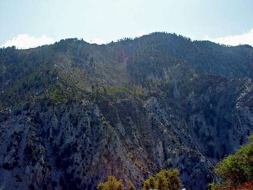
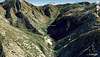
Part 1: A little bit concerned about our group size we started up the Icehouse Canyon along the creek passing some picturesque cabins. At the first major switchback (~5,280’) we crossed the creek to the south and scrambled up to the entrance of Falling Rock Canyon (~5,320’), which is basically the first visible canyon leading south from Icehouse Canyon separating Sugarloaf Peak from the Ontario Peak massif. We made good progress scrambling over some big boulders until we reached the first dried-up waterfall. We decided to climb the waterfall on the left (east) side, which involved some brief but fun class 3 climbing. On top of the waterfall the canyon narrowed and steep rock walls covered with loose rocks were towering above us on both sides. The Falling Rock Canyon often seemed to have fun big boulders on one side and loose talus on the other side. Obviously we mostly chose to climb over the big boulders further up. At about 6,200 feet, we reached the first prominent talus slope leading west, which we thought will lead directly to the false summit east of Sugarloaf Peak. Most reports described another scree slope further up the canyon, which leads to the saddle north of Sugarloaf Peak. We decided to take the first talus slope. The terrain swiftly changed from fun bouldering to a strenuous steep climb over loose talus. We were still mainly climbing in a tight single file. We knocked many smaller rocks loose but since we were all still close to each other we were not concerned and everything seemed ok. The slope offered a serious talus climb to the left (north) or some mainly climbing portions to the right (south). Some of us decided to take the scree slope while most of us climbed the bigger rocks, which we found out very soon to be covered with very loose, smaller rocks. Since the loose talus slope got way too strenuous the guys going up that route soon joined the rest of us on the other side. Although we were climbing relatively slow and carefully, more and bigger rocks were knocked loose and crashed down the steep slope. We decided to hide at safe spots until the guys in the front climbed higher and then secured their position. We then followed until we caught up. However, even as carefully as we proceeded we kept knocking loose more and more rocks, some of which crashed down seriously close to some of us. Sometimes we had to wait for minutes until it seemed safe enough to continue climbing up. Recognizing that it could become even more risky we decided to climb in small groups in parallel chutes up thereby avoiding having somebody climbing in front of others. This strategy proved extremely helpful and efficient. We often heard and saw rocks crushing down on both sides but nobody in our group was at risk anymore. All warnings about the risk of getting hit by rocks in this canyon are certainly more than justified. Although in parallel groups, the climb was everything but easy. We progressed fairly slowly because of the steepness and looseness of the terrain. We often pulled ourselves up by the branches of the sparse bushes dotting the slope. Eventually, we reached the ridge directly at the false summit east of Sugarloaf Peak (~6,900’). From the entrance of Falling Rock Canyon to the false summit we climbed about 1,600 feet in 0.6 miles (average grade: 35%). The steep talus slope covered about 600 feet in 0.25 miles (average of 50%). After catching some breath and licking our wounds we headed over the brief ridge to the true summit of Sugarloaf Peak (6,924 feet) to have some well deserved lunch and rest. The view was unobstructed in all directions and as we often do we already made plans for another hike. The ridge (north of Cedar Canyon) leading directly up from Icehouse Canyon trailhead towards Thunder Mountain looked very tempting.
![Ontario Peak]()
After a short break we descended to the saddle (6,680’) recognizing the scree slope to the east down Falling Rock Canyon. This slope indeed seemed a bit easier than the route we took. From the saddle the ridge leading up towards Ontario Peak was a fun scramble over bigger and smaller rocks. The first part up the ridge was quite steep with 700 feet elevation gain in ~0.35 miles (average grade: 40%). The view to both sides was amazing. There were no real difficulties although the legs felt pretty drained after the previous uphill battle. At one point we took a path that seemed to lead down to the canyon bottom again. Some of us turned back to get back where we left the ridge; others climbed straight up the slope until they reached the ridge. Basically, you can’t go wrong if you stay directly on the ridgeline. Further up the ridge (~8,120’) the terrain opened up to a small bowl, which we hiked cross-country straight up to the visible Ontario Peak ridge (~8,560’). On that ridge we connected with the Ontario Peak Trail which led us in 0.25 miles southwest to the summit of Ontario Peak (8,693 feet). Beautiful, unobstructed views again.
![Ontario Peak Summit]()
After a rest we took the Ontario Peak Trail back towards Icehouse Saddle. We felt all good and decided to bag Bighorn Peak on our way back. We missed the faint trail leading to the saddle south of Bighorn Peak, so we had to scramble up from near Kelly’s Camp up to the ridge. After more than 4,500 vertical feet of tough, mostly trail-less uphill we all felt our legs. Most of us decided to descend directly from the summit of Bighorn Peak in one of the north facing canyons to Icehouse Saddle. Two headed east to bag Cucamonga as well. The descent turned out to be a fun glissading down the steep scree slope until we crossed the Ontario Peak trail (at ~7,620’) just shortly southwest of Icehouse Saddle. The gully we took dropped down 800 feet in about 0.4 miles (average grade: 40%). The remainder of our hike was a nice 3-mile stroll down the Icehouse Canyon to the parking lot. Overall the hike totaled to almost 10 miles with ~5,000 feet of elevation gain. We ended our day at a nice Mexican Restaurant reliving our previous adventure.
Disclaimer: The track was recorded on a Garmin GPSmap 60CSx with coordinate savings every 30 seconds. Mileage- and elevation readings were calculated after importing the gpx file into National Geographic’s Topo 4.0 software. Below are some Google Earth Renditions of the described hike.
Comments
No comments posted yet.