
|
|
Route |
|---|---|
|
|
42.75240°N / 0.1965°W |
|
|
Hike |
|
|
Most of a day |
|
|
Walk-up |
|
|
Approach
You have to start from Baños de Panticosa, a 19th-century spa resort placed at 1636 meters of altitude. To get there, take at Huesca road number N-330 to Sabiñánigo, across the tunnels of Monrepos. After Sabiñánigo you have to get road N260 north for 13 km to Biescas. North of Biescas, follow the road to the french border and turn right before Escarrilla (road sign "Panticosa / El Pueyo de Jaca". Then follow the signs to Balneario de Panticosa.Another possibility is to approach from the city of Pamplona (via road N-240 towards Huesca, turning left to Jaca and Sabiñánigo at Puente la Reina de Jaca). In order to get to Panticosa from France, you will need to cross the mountain pass of Portalet from Pau and Laruns. Note that the road crossing this mountain pass is usually a troublesome one during winter, and you might find it closed. In such a case, the only road access from France would have to take place by the neighbouring valley of Aragón and the Somport Tunnel.
NEAREST MAJOR AIRPORTS: Zaragoza / Barcelona (323 km)
RAILWAY ACCESS: The closest rail station is the one at Sabiñánigo (some thirty to forty kilometers south of Balneario de Panticosa)
Route Description

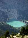
Start walking from the Gran Hotel de Panticosa, turning right (east) to take a staircase leading to a mineral water fountain. Turn left and start following the trail GR-11, wonderfully marked by red and white parallel paint marks. All you will have to do in order to reach the Cuello Alto de Brazato is to follow these marks, paying no attention at any other path (no matter how tempting it might be) that does not show them. In this way the GR-11 goes up the mountain, turning once and again through the forest. There is a point where a small path leaves left, but it’s properly marked on a big rock (left-“Labaza”, right-“Brazato”). Take the right arm of this forking, towards Brazato. About an hour after beginning the climb you will see to your right a mountain hut (free lodging, no guards nor services) and shortly after that the path shall go up a grassy slope in order to enter a high valley close to the Ibones (local term for lakes) de Brazato.
Two hours after leaving the Balneario de Panticosa you will reach the dam of the Ibón superior de Brazato (nearby small hut, suitable for emergencies). The GR-11 keeps going to your left, by the bank of the lake and soon turns winding uphill in search of the Ibones Altos de Brazato and (some 45 minutes after the dam) the Cuello Alto de Brazato.
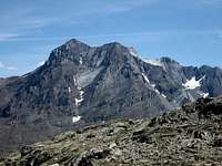
The summit is marked by a big pile of stones, constituting a geodesical vertex.
 |  |  |