
|
|
Route |
|---|---|
|
|
37.90012°N / 107.51473°W |
|
|
Mountaineering, Skiing |
|
|
Spring, Winter |
|
|
Half a day |
|
|
Moderate Snow (up to 42°) |
|
|
I |
|
|
Approach
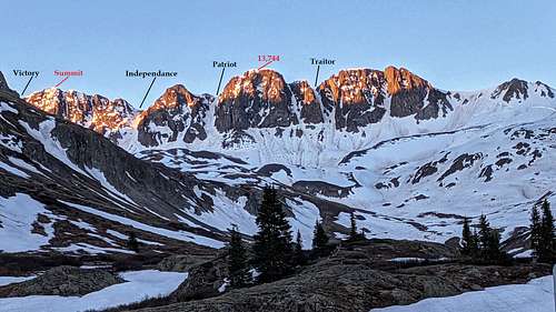
Of the four north-facing couloirs on American Peak, Independence is one of the two easiest. This couloir garners a solid easy to moderate rating. Looking south up into Americn Basin, Independence Couloir is the line just east of Point 13,744. This is probably the best couloir on American to climb if you're new to coullies. It rarely if ever cornices.
Head south into the basin on snow or if it's melted out, follow Jeep road #3314. This isn't necessary of course, but it will speed up ons progress. Stay to the left of the creek (east) and hike up easy embankments and hills to Sloan Lake at 12,900'.
From this lake/bench area (the views up at American are quite good!), you'll be able to look up into both Independence and Patriots couloirs. The run-outs on these couloirs are long and wide. The aprons also make for good last-minute self arrest practice areas before commiting. Independence is the eastern one. Throw on those crampons and start up.
American Peak is located in the Handies Peak quad.
Getting There
From Lake City, drive 2 miles south on Colorado 149 and turn right (an abrupt turn) onto County Road 3 (Lake San Cristobal). This is the southern entrance to the "Alpine Loop" scenic byway.
Follow the signs to Cinnamon Pass driving through gorgeous valley, shelf road and up into Burrows Park. Drive about ~20 miles to a signed fork in the road. Left is to American Basin and right is to Cinnamon Pass. Turn left. If you do not have a 4WD vehicle with good clearance, park in the pull-offs near the start of this road.
It’s 0.9 mile to the trailhead from the start of the American Basin road. After 0.2 mile, cross a stream which can be fairly deep in spring. If you don’t feel comfortable driving through the water, there are some parking spots in the area. Continue to the end of the road where you’ll find a large parking area and marked trail. There is also a mine here called the "Old Gnome Mine." In spring, because of the piled snow from the plows, you'll probably have to park at the sign. There is a small turn-out here.
Route Description
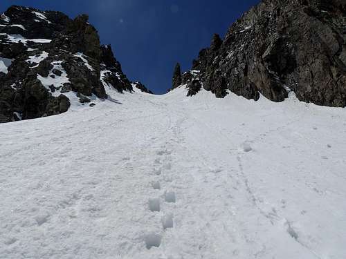
Climb up the apron leaving Sloan Lake on gradually steepening snow. The apron and lower couloir averages about 32º near the bottom (13,150') and steepens consistently. The steepest pitch comes about half-way. Expect the pitch to increase to about 41º at the most.
Past the center, the inclination will drop slightly to 38-40º and for the most part, will stay at that angle.
This couloir contains no 'hidden surprises', gendarmes, spires or rock pitches. Continue climbing up either the center or veer slightly climber's left. This is only for safety in case of rock fall of the false summit climber's right.
About 3/4 the way up, the pitch will drop even more to around ~37º before finishing gently on the summit ridge (13,716'). The exit does not cornice.
Turn left and walk to the summit still .15 mile away.
Both the actual summit and the false summit cornice heavily. So proceed with caution.
The views of Jones Peak to the southwest and the 14ers, Uncompaghre/Wetterhorn to the north are amazing! Either retrace your steps or descend a different couloir!
Essential Gear
A mountaineering axe and crampons are absolutely mandatory. Even though the pitch is low, always expect the possibility of encountering ice.
- gaiters
- shovel
- sunscreen/hat
- probe & beacon
- poles
- regular winter clothing/gear
External Links
- Information pile from 13ers.com
- American Peak -Lists of John
- Trip Report from 14ers.com
- Trip report from Kevin Baker